
Search the Special Collections and Archives Portal

Search Results

Display    Results Per Page
Displaying results 6751 - 6760 of 579530

San Pedro, Los Angeles & Salt Lake Railroad Company and Salt Lake and Ogden Railway bills of lading, approximately 1900 to 1910

Level of Description

File

Archival Collection

UNLV Libraries Collection on the Union Pacific Railroad in Las Vegas, Nevada
To request this item in person:
Collection Number: MS-00751
Collection Name: UNLV Libraries Collection on the Union Pacific Railroad in Las Vegas, Nevada
Box/Folder: Box 01

Archival Component

Men of the Rochester-Goldfield Mining Company sit in horse-drawn wagons. Rinker is seated in first wagon: photographic print, approximately 1900-1910

Level of Description

Item

Archival Collection

C. A. Earle Rinker Photograph Collection of Goldfield, Nevada
To request this item in person:
Collection Number: PH-00350
Collection Name: C. A. Earle Rinker Photograph Collection of Goldfield, Nevada
Box/Folder: Folder 05

Archival Component

"Fishing trip near Moapa. Early Las Vegans: Ray Mosbach family, Jim Adams family, Leon Rockwell, Sr. family" (written on verso): photographic print, approximately 1915 to 1925

Level of Description

Item

Archival Collection

Leon Rockwell Photograph Collection
To request this item in person:
Collection Number: PH-00008
Collection Name: Leon Rockwell Photograph Collection
Box/Folder: Folder 20

Archival Component

Map of Las Vegas Rancho, Lincoln County, Nevada, September 15, 1904

Date

1904-09-15

Description

'Being part of Township 20 S. R.61 E. MT. D. B.&.M, containing 1864.49 acres. Division engineer's office at the front, AMB, September 15th, 1904. A.L. Jones, Division Engineer. Surveyed by W.G. Watson, Assistant Engineer. Dwg. 30296.' Includes traverse table. Shows land owned by the San Pedro, Los Angeles & Salt Lake Railroad, its right of way and the right of way for the Las Vegas & Tonopah Railroad, land owned by the Las Vegas Land & Water Company including Clark's Las Vegas Townsite with the Bucks Addition and the Wardie Addition, and parcels sold from the Las Vegas Land & Water Company land. Scale: [1:9,600]. 1 in. to 800 feet. Library's copies 1 and 4 have land owned by the San Pedro, Los Angeles & Salt Lake Railroad hand-colored in pink and the rest of the Las Vegas Rancho not owned by the Las Vegas Land & Water Company hand-colored in green. Library's copy 2 has buildings of the Stewart Ranch drawn in and labeled in pencil. Library's copy 3 has addition and subtraction problems in pencil on the verso. Library's copy 4 has "Original purchase--1864.49 acres R.R.C. + L.V.L. + W. Co.--In colors." written in pencil on the verso followed by "(1904)" in red pencil. Library's copy 4 also has label on verson made of brown paper with "No 5 Las Vegas Ranch being part township ( 1904)" typed on it.

Image

Haller, Mark H. Bootleggers as Businessmen: From City Slums to City Builders, Law, Alcohol, and Order: perspectives on national prohibition, approximately 1900 to 1999

Level of Description

File

Archival Collection

UNLV Libraries Collection of Articles on Gaming and Las Vegas, Nevada Topics
To request this item in person:
Collection Number: MS-00626
Collection Name: UNLV Libraries Collection of Articles on Gaming and Las Vegas, Nevada Topics
Box/Folder: Box 19

Archival Component

Butterfield, Roger. Harold's Club: Country's biggest gambling joint run by Smith family of Reno, Life 19(16), approximately 1900 to 1999

Level of Description

File

Archival Collection

UNLV Libraries Collection of Articles on Gaming and Las Vegas, Nevada Topics
To request this item in person:
Collection Number: MS-00626
Collection Name: UNLV Libraries Collection of Articles on Gaming and Las Vegas, Nevada Topics
Box/Folder: Box 10

Archival Component

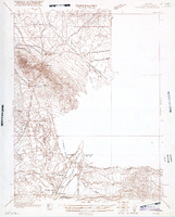
Map of Ely Range Quadrangle, Lincoln County, Nevada, 1921

Date

1921

Description

'Edition of 1921.' 'W. H. Herron, Acting Chief Geographer; Geo. R. Davis, Geographer In Charge; Topography by H. H. Hodgeson, N. E. Ballmer, and W. B. Upton, Jr.; Control by H. H. Hodgeson, Roscoe Reeves, and D. S. Birkett. Surveyed in 1916.' At top of map: ' Topography, State of Nevada.' At upper left corner: ' Department of the Interior, Albert B. Fall, Secretary; U.S. Geological Survey, George Otis Smith, Director.' Southern Nevada Mining Map Collection. 15 minute series (topographic) Nevada.

Image

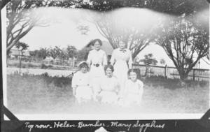
Film transparency of Helen Bunker, Mary Syphus, Florence Bishop, Zella Peterson, and Wanda Ball, presumably in Las Vegas, circa early 1900s

Date

1900 to 1939

Description

Black and white image of five young women posing for a photo, most likely in Las Vegas, Nevada. The women standing in the top row are Helen Bunker and Mary Syphus, per the handwritten description on the image. The women in the bottom row include Florence Bishop, Zella Peterson, and Wanda Ball. Note: Image is from a family photo album that was loaned to UNLV Libraries Special Collections and returned to the family on July 17, 1984.

Image

Map showing detailed topography of the country traversed by the reconnaissance expedition through southern & southeastern Nevada, 1869 (reproduction)

Date

1869

Description

At top of map: 'Reconnaissance Maps, Department of California.' 'In charge of, Lieut. Geo. M. Wheeler, U.S. Engineers; assisted by Lieut. D.W. Lockwood, Corps of Engineers,U.S.A., 1969.' 'P.W. Hamel, chief topographer and draugthsman.' 'Traced 11-13-67.' 'BGS'; the G is enclosed in an arrowhead shape. 'Officially compiled and published at the Engineer Office, Head Quarters Department of California in 1869 and 70 by order of Brigadier General E.O.C. Ord. Comm'dg. [signed] Geo. M. Wheeler, Lieutenant of Engineers In Charge, Head Quarters Dept. of Cal. Oct. 26th, 1870.' Includes information from railroad maps, the United States Geological Survey of the 40th parallel and from Lieutenant Ives' explorations along the Colorado. Map includes camps, astronomical stations, good and bad wagon roads, trails, springs, settlements, mining districts, state and county boundaries and the watershed between the Humboldt and Colorado Basin. Shows most of eastern half of Nevada. Relief shown by hachures and spot heights. Scale indeterminable. (W 117°00´--W 113°00´/N 41°45´--N 35°45´). Series: Reconnaissance maps. Military map / Department of California
no. 1. Reproduction. Map is printed in purple. Scale of original map: [1:760,320]. 1 in. to approx. 12 miles. Includes dots hand-colored with red pencil marking Indian rancherias.

Image

Blueprint showing proposed pipeline for gravity water supply at Las Vegas, Nevada, February 16, 1905

Date

1905-02-16

Description

'Office of Chief Engineer, Los Angeles, Cal., Feb. 16, 1905.' '2-18-17' hand-printed in lower right corner. Proposed pipeline is printed in red. Scale [1:6,000]. 1 inch to 500 feet. San Pedro, Los Angeles & Salt Lake Railroad Company. Office of Chief Engineer

Image