Search Results
Las Vegas Valley Water District: "Comprehensive Annual Report for Fiscal Year Ended June 30, 2011", 2011 November 09
Level of Description
File
Archival Collection
Bruce Turner Collection on Transportation and Water in Southern Nevada
To request this item in person:
Collection Number: MS-00648
Collection Name: Bruce Turner Collection on Transportation and Water in Southern Nevada
Box/Folder: Box 12
Collection Name: Bruce Turner Collection on Transportation and Water in Southern Nevada
Box/Folder: Box 12
Archival Component
Las Vegas Valley Water District: "Comprehensive Annual Financial Report for the Fiscal Year Ended June 30, 2001", 2001 November
Level of Description
File
Archival Collection
Bruce Turner Collection on Transportation and Water in Southern Nevada
To request this item in person:
Collection Number: MS-00648
Collection Name: Bruce Turner Collection on Transportation and Water in Southern Nevada
Box/Folder: Box 11
Collection Name: Bruce Turner Collection on Transportation and Water in Southern Nevada
Box/Folder: Box 11
Archival Component
#64376: 25 Year Awards (Klinkhammer, Lucy; Cloud, Barbara; Karstensonn, Louis; Parker, Steve; Sevalshad, Suzanne), 2004 October 14
Level of Description
File
Archival Collection
University of Nevada, Las Vegas Creative Services Records (2000s)
To request this item in person:
Collection Number: PH-00388-04
Collection Name: University of Nevada, Las Vegas Creative Services Records (2000s)
Box/Folder: N/A
Collection Name: University of Nevada, Las Vegas Creative Services Records (2000s)
Box/Folder: N/A
Archival Component
#64178: Classified Employees of the Year - Colbert, Rebecca (Law); Anderson, Andy (Alarms); Bolton, Becky (Graduate College), 2004 April 27
Level of Description
File
Archival Collection
University of Nevada, Las Vegas Creative Services Records (2000s)
To request this item in person:
Collection Number: PH-00388-04
Collection Name: University of Nevada, Las Vegas Creative Services Records (2000s)
Box/Folder: N/A
Collection Name: University of Nevada, Las Vegas Creative Services Records (2000s)
Box/Folder: N/A
Archival Component
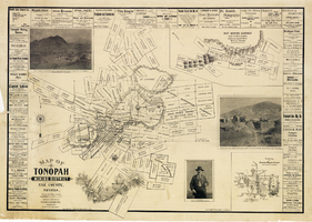
Map of Tonopah Mining District, Nye County, Nevada, 1902
Date
1902
Description
'Compiled and published by Booker & Bradford, engineers, Tonopah, Nevada.' 'Copyrighted by Booker & Bradford 1902.' 'Lith. Britton & Rey, S.F., Cal.' Relief shown by hachures. Includes insets of Ray Mining District, Nye County, Nevada, and Vicinity map of Tonopah Mining District, Nye County, Nevada. Includes advertisements and photographs of Tonopah ore, town of Tonopah, and of J.L. Butler, discoverer of the Mizpah Lode. Scale [ca. 1:7,200]. 1 inch to 600 feet. Mounted on linen.
Text
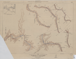
Map of plan and profile of Colorado River from Lees Ferry, Arizona to Black Canyon, Arizona-Nevada and Virgin River, Nevada, 1924
Date
1924
Archival Collection
Description
1 map in 21 sheets (14 plans, 7 profiles): col. ; 46 x 64 cm. Notes Relief shown by contours. Each sheet includes a key map. Surveys for individual sheets conducted 1919-23. Library has: Sheets I (2 copies), J, K, L, M, and N only. "Contour interval on land 50 feet." "Contour interval on river surface 5 feet." "Datum is mean sea level." "Mileage is measured from U. S. G. S. concrete gauge well opposite mouth of Paria River." "Topography by U. S. Reclamation Service." "Surveyed in 1919-23." Original publisher: U.S. Geological Survey, Scale: 1: 81,680.
Image
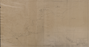
Map of general plan for the Wells Siding Project in Logandale, Nevada, May 15, 1935
Date
1935-05-15
Archival Collection
Description
'U.S. Department of Agriculture, Forest Service, Camp P.E. 206.' 'By C.C.C. Company, 538. Drawn by Ed Overton. Approved ... 5-15-35.Traced by Ed Overton.'
Image
Feinstein, Andrew Hale, "A proposed community college two year hospitality program relative to the needs of the Mammoth Lake community", 1995 Spring
Level of Description
Item
Archival Collection
University of Nevada, Las Vegas Theses, Dissertations, and Honors Papers
To request this item in person:
Collection Number: UA-00082
Collection Name: University of Nevada, Las Vegas Theses, Dissertations, and Honors Papers
Box/Folder: Box 112
Collection Name: University of Nevada, Las Vegas Theses, Dissertations, and Honors Papers
Box/Folder: Box 112
Archival Component
#68635: Christina Hernandez, Outreach & Awareness Coordinator at the Jean Nidetch Women's Center, professional staff member of the year., 2012 May
Level of Description
File
Archival Collection
University of Nevada, Las Vegas Creative Services Records (2010s)
To request this item in person:
Collection Number: PH-00388-05
Collection Name: University of Nevada, Las Vegas Creative Services Records (2010s)
Box/Folder: Digital File 00
Collection Name: University of Nevada, Las Vegas Creative Services Records (2010s)
Box/Folder: Digital File 00
Archival Component
#71526: Engelstad Scholars End of the Year Celebration at the Blasco Event Wing of the Foundations Building, April 28, 2017, 2017 April 28
Level of Description
Item
Archival Collection
University of Nevada, Las Vegas Creative Services Records (2010s)
To request this item in person:
Collection Number: PH-00388-05
Collection Name: University of Nevada, Las Vegas Creative Services Records (2010s)
Box/Folder: Digital File 01
Collection Name: University of Nevada, Las Vegas Creative Services Records (2010s)
Box/Folder: Digital File 01
Archival Component