Search Results

Topographic map of Cane Spring, Nevada quadrangle, 1961
Date
1961
Description
'Mapped, edited and published by the Geological Survey in cooperation with the Atomic Enegry Commission. Control by USGS, USC&GS, USCE, and Atomic Energy Commission. Topography from aerial photographs by photogrammetric methods. Aerial photographs taken 1959. Field check 1961.' Scale 1:24,000 polyconic projection (W 116°07'30"--W 116°00'00"/N 36°52'30"--N 36°45'00"). Series: 7.5 minute series (topographic). Relief shown by contours and spot heights. Contour interval 20 feet. Includes quadrangle location map. Interior--Geological Survey
For sale by the U.S. Geological Survey
For sale by the U.S. Geological Survey
Image
Geologic map of the Topopah Spring NW quadrangle, Nye County, Nevada, 1965
Date
1965
Description
58 x 47 cm., on sheet 84 x 89 cm., folded in envelope 30 x 24 cm. Relief shown by contours and spot heights. "Contour interval 20 feet." "Prepared in cooperation with the U. S. Atomic Energy Commission." "Geology mapped by R. L. Christiansen, P. W. Lipman, and H. R. Cornwall, 1962." Includes text, 3 col. cross sections, and quadrangle location map. Original publisher: Interior, Geological Survey, Series: Geologic quadrangle map GQ, Scale: 1:24 000.
Image

Geologic map of the Paiute Ridge quadrangle, Nye and Lincoln Counties, Nevada, 1967
Date
1967
Description
58 x 46 cm., on sheet 85 x 83 cm., fold. in envelope 30 x 24 cm. Relief shown by contours and spot heights. "Contour interval 20 feet." "Prepared in cooperation with the U.S. Atomic Energy Commission." "Geology mapped in 1961. Contours on pre-Tertiary rocks by D. L. Healey and C. H. Miller, 1963." Includes text, 4 col. cross sections, and quadrangle location map. Original publisher: U. S. Geological Survey, Series: Geologic quadrangle map GQ, Scale: 1:24 000.
Image

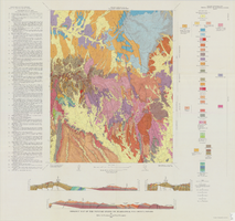
Geologic map of the Jangle Ridge quadrangle, Nye and Lincoln Counties, Nevada, 1965
Date
1965
Description
58 x 46 cm., on sheet 84 x 87 cm., folded in envelope 30 x 24 cm. Relief shown by contours and spot heights. "Contour interval 20 feet." "Prepared in cooperation with the U.S. Atomic Energy Commission." "Geology mapped in 1961. Limit of pluvial Groom Lake and faults from photographs mapped by R. B. Colton, 1962." Includes text, bibliography, location map, and 5 col. cross sections. Original publisher: Interior, U.S. Geological Survey, Series: Geologic quadrangle map GQ, Scale: 1:24 000.
Image

Graduate College executive director of graduate student services and administrative faculty member of the year Valarie Burke with her 8-month-old son Jace on May 25, 2016: digital photographs
Date
2016-05-25
Archival Collection
Description
Photographs from the University of Nevada, Las Vegas Creative Services Records (2010s) (PH-00388-05).
Image
Las Vegas Valley Water District: "Comprehensive Annual Financial Report for the Year Ended June 30, 2010", 2010 November 15
Level of Description
File
Archival Collection
Bruce Turner Collection on Transportation and Water in Southern Nevada
To request this item in person:
Collection Number: MS-00648
Collection Name: Bruce Turner Collection on Transportation and Water in Southern Nevada
Box/Folder: Box 12
Collection Name: Bruce Turner Collection on Transportation and Water in Southern Nevada
Box/Folder: Box 12
Archival Component
Las Vegas Valley Water District: "Comprehensive Annual Financial Report for Year Ended June 30, 2009", 2009 December 08
Level of Description
File
Archival Collection
Bruce Turner Collection on Transportation and Water in Southern Nevada
To request this item in person:
Collection Number: MS-00648
Collection Name: Bruce Turner Collection on Transportation and Water in Southern Nevada
Box/Folder: Box 12
Collection Name: Bruce Turner Collection on Transportation and Water in Southern Nevada
Box/Folder: Box 12
Archival Component
Las Vegas Valley Water District: "Comprehensive Annual Financial Report for the Year Ended June 30, 1995", 1995 November 17
Level of Description
File
Archival Collection
Bruce Turner Collection on Transportation and Water in Southern Nevada
To request this item in person:
Collection Number: MS-00648
Collection Name: Bruce Turner Collection on Transportation and Water in Southern Nevada
Box/Folder: Box 12
Collection Name: Bruce Turner Collection on Transportation and Water in Southern Nevada
Box/Folder: Box 12
Archival Component
Las Vegas Valley Water District: "Comprehensive Annual Financial Report for the Year Ended June 30, 1997", 1997 November 06
Level of Description
File
Archival Collection
Bruce Turner Collection on Transportation and Water in Southern Nevada
To request this item in person:
Collection Number: MS-00648
Collection Name: Bruce Turner Collection on Transportation and Water in Southern Nevada
Box/Folder: Box 12
Collection Name: Bruce Turner Collection on Transportation and Water in Southern Nevada
Box/Folder: Box 12
Archival Component