
Search the Special Collections and Archives Portal

Search Results

Display    Results Per Page
Displaying results 1491 - 1500 of 577652

Eleventh Annual Report. Colorado River Storage Project and Participating Projects for the Fiscal Year Ended June 30, 1967, 1967

Level of Description

File

Archival Collection

Howard Cannon Papers
To request this item in person:
Collection Number: MS-00002
Collection Name: Howard Cannon Papers
Box/Folder: Box 43 (90th Session)

Archival Component

Plat showing original townsite and subdivisions, Las Vegas, Lincoln County, Nevada, May 1905

Date

1905-05

Description

Land owned by the San Pedro, Los Angeles & Salt Lake Railroad is outlined. Scale: [ca. 1:12,000]. 1 inch = 1,000 feet. Cadastral map. Blueline print. Additional copy available in the J.T. McWilliams manuscript collection

Image

Map of the Livingston Ranches near Overton, Clark County, Nevada, March 27, 1920

Date

1920-03-27

Description

Cadastral map. "Las Vegas Plat Book 1, page 42 --Lower left hand corner. "Survey completed March 27th, 1920, J. T. McWilliams, O. E." "Inset plat showing fractional areas adjacent to section corner sections = 12-13 Tp16S.R.67E, 7-18 Tp16S.R68E." Signed by the surveyor on March 28, 1920, and notarized. Includes an inset plat showing fractional area adjacent to section corner, sections 12-13 Tp. 16 S. R. 76 E., 7-18 Tp. 16 S. R. 6 8 E. Includes table of areas of tracts and table of reference ties to scribe marked objects. Recorded in Book 1, page 42 in the County Recorder of Deed's office. Includes township and range grid. Original publisher: Clark County, State of Nevada : D.H. Livingston, 1920, Scale: 600, blue, 82 x 68 cm.

Image

S. Joint Resolution 132, Pony Express Year. Contains correspondence, resolution, press clippings and memos, 1959 August to 1959 October

Level of Description

File

Archival Collection

Howard Cannon Papers
To request this item in person:
Collection Number: MS-00002
Collection Name: Howard Cannon Papers
Box/Folder: Box 35 (86th Session)

Archival Component

S#259 - Goldwater. S.S. Limitation Earnings - 65 years old. Contains correspondence, papers and memos, 1975 February to 1982 November

Level of Description

File

Archival Collection

Howard Cannon Papers
To request this item in person:
Collection Number: MS-00002
Collection Name: Howard Cannon Papers
Box/Folder: Box 81 (97th Session)

Archival Component

S.J. Res. 35 18-Year-Old Voting. Contains correspondence, remarks, resolution and memo, 1965 February to 1966 August

Level of Description

File

Archival Collection

Howard Cannon Papers
To request this item in person:
Collection Number: MS-00002
Collection Name: Howard Cannon Papers
Box/Folder: Box 48 (89th Session)

Archival Component

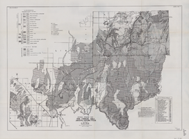
General geologic map of the Corners area, Arizona-Nevada-Utah, April 15, 1952

Date

1952-04-15

Description

46 x 65 cm. "IAPG guide book #7. General plate #1." "April 15, 1952." Includes bibliographic references and index of drilled wells Includes township and range grid. "Drawn by Oscar Baide, Jack Harde." "Compiled by I.A.P.G. under direction of L.F. Wells." Original publisher: I.A.P.G..

Image

Map of Las Vegas and vicinity, Nevada, circa 1957-1961

Date

1957 to 1961

Description

70 x 68 cm. on sheet 106 x 71 cm. Includes indexes. Includes Nellis Air Force Base, Henderson, and inset maps of Boulder City, Nevada, and Las Vegas's geographical location in the Southwest. "H-654-32" on the lower right-hand corner. Page 2 contains a photograph of the Fremont Street in Downtown Las Vegas, featuring the Golden Nugget Gambling Hall and the Horseshoe Casino. Page 3 outlines local and regional attractions, as well as population information. Original publisher: R. L. Polk.

Image

Geologic map of the Dead Horse Flat quadrangle, Nye County, Nevada, 1967

Date

1967

Description

58 x 46 cm., on sheet 77 x 84 cm., folded in envelope 30 x 24 cm. Relief shown by contours and spot heights. "Base by U.S. Geological Survey, 1960." "Geology mapped in 1962-64." "Contour interval 20 feet." Includes 2 col. cross sections, quadrangle location map, and text. "Prepared in cooperation with the U. S. Atomic Commission." Original publisher: Interior, Geological Survey, Series: Geologic quadrangle map GQ, Scale: 1:24 000.

Image

Nevada Library Notes

Date

1964 to 1967

Description

Nevada Library Notes, Vol. 1-4 issued by the Nevada State Library. Materials about the news of library activities and articles for publication by Nevada librarians. It also contains minutes of the 18th annual convention. 

Text