Search Results
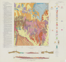
Geologic map of the Topopah Spring NW quadrangle, Nye County, Nevada, 1965
Date
1965
Description
58 x 47 cm., on sheet 84 x 89 cm., folded in envelope 30 x 24 cm. Relief shown by contours and spot heights. "Contour interval 20 feet." "Prepared in cooperation with the U. S. Atomic Energy Commission." "Geology mapped by R. L. Christiansen, P. W. Lipman, and H. R. Cornwall, 1962." Includes text, 3 col. cross sections, and quadrangle location map. Original publisher: Interior, Geological Survey, Series: Geologic quadrangle map GQ, Scale: 1:24 000.
Image

Geologic map of the Paiute Ridge quadrangle, Nye and Lincoln Counties, Nevada, 1967
Date
1967
Description
58 x 46 cm., on sheet 85 x 83 cm., fold. in envelope 30 x 24 cm. Relief shown by contours and spot heights. "Contour interval 20 feet." "Prepared in cooperation with the U.S. Atomic Energy Commission." "Geology mapped in 1961. Contours on pre-Tertiary rocks by D. L. Healey and C. H. Miller, 1963." Includes text, 4 col. cross sections, and quadrangle location map. Original publisher: U. S. Geological Survey, Series: Geologic quadrangle map GQ, Scale: 1:24 000.
Image
Main Street, Goldfield, Nevada, postcard
Description
Postcard of Main Street, Goldfield, Nevada.

Geologic map of the Jangle Ridge quadrangle, Nye and Lincoln Counties, Nevada, 1965
Date
1965
Description
58 x 46 cm., on sheet 84 x 87 cm., folded in envelope 30 x 24 cm. Relief shown by contours and spot heights. "Contour interval 20 feet." "Prepared in cooperation with the U.S. Atomic Energy Commission." "Geology mapped in 1961. Limit of pluvial Groom Lake and faults from photographs mapped by R. B. Colton, 1962." Includes text, bibliography, location map, and 5 col. cross sections. Original publisher: Interior, U.S. Geological Survey, Series: Geologic quadrangle map GQ, Scale: 1:24 000.
Image

Map of California, Utah, Nevada, Colorado, New Mexico and Arizona, 1864
Date
1864
Description
'Johnson's California, also Utah, Nevada, Colorado, New Mexico, and Arizona, published by A.J. Johnson, New York.' 'Entered according to Act of Congress in the Year 1864, by A.J. Johnson in the Clerks Office of the District Court of the United States for the Southern District of New York.' Atlas page numbers in upper margin: 66-67. Relief shown by hachures. Prime meridians: Greenwich and Washington, D.C. Shows proposed railroads, locations of Indian tribes, natural features, counties, mines, mail routes, trails and routes of exploring expeditions. On verso: History and statistics of Mexico and Central America and statistics of national finances and the Post Office of the United States, 1860. Scale [ca. 1:3,484,800. 1 in. to ca. 55 miles] (W 123°--W 103°/N 42°--N 32°)
Text
The History of the Convict Hulk "Success" and "Success" Prisoners by Harvie, Joseph C. . Leeds: Petty & Sons, Ltd., 1900
Level of Description
Item
Archival Collection
Mavis Eggle "Books as They Were Bought" Collection
To request this item in person:
Collection Number: MS-01144
Collection Name: Mavis Eggle "Books as They Were Bought" Collection
Box/Folder: No Container 00
Collection Name: Mavis Eggle "Books as They Were Bought" Collection
Box/Folder: No Container 00
Archival Component
Electric Service Supplies Co.: Philadelphia-Chicago-New York Franklin Sales Co. catalog no. 5, 1900 to 1909
Level of Description
Item
Archival Collection
Raymond Brooks Papers on Mining
To request this item in person:
Collection Number: MS-01153
Collection Name: Raymond Brooks Papers on Mining
Box/Folder: Box 05
Collection Name: Raymond Brooks Papers on Mining
Box/Folder: Box 05
Archival Component
Betty Trevor by de Horne Vaizey, Mrs. George. London: The Religious Tract Society, approximately 1900 to 1909
Level of Description
Item
Archival Collection
Mavis Eggle "Books as They Were Bought" Collection
To request this item in person:
Collection Number: MS-01144
Collection Name: Mavis Eggle "Books as They Were Bought" Collection
Box/Folder: No Container 00
Collection Name: Mavis Eggle "Books as They Were Bought" Collection
Box/Folder: No Container 00
Archival Component
Rubaiyat of Omar Khayyam: the astronomer poet of Persia by Edward Fitz Gerald. London: T. N. Foulis, approximately 1900 to 1909
Level of Description
Item
Archival Collection
Mavis Eggle "Books as They Were Bought" Collection
To request this item in person:
Collection Number: MS-01144
Collection Name: Mavis Eggle "Books as They Were Bought" Collection
Box/Folder: Box 30
Collection Name: Mavis Eggle "Books as They Were Bought" Collection
Box/Folder: Box 30
Archival Component
Diamond Cut Paste by Castle, Agnes
Castle, Egerton. London: C. Arthur Pearson, Ltd., approximately 1900 to 1909
Level of Description
Item
Archival Collection
Mavis Eggle "Books as They Were Bought" Collection
To request this item in person:
Collection Number: MS-01144
Collection Name: Mavis Eggle "Books as They Were Bought" Collection
Box/Folder: No Container 00
Collection Name: Mavis Eggle "Books as They Were Bought" Collection
Box/Folder: No Container 00
Archival Component