Search Results

Map of Argentite Red Mountain Mining District, Esmeralda County, Nevada, circa 1908-1913
Date
Description
Image
J. Ross Clark, Miriam Clark, and James Ross Clark II: photographic prints and negatives, approximately 1900 to 1920
Level of Description
Archival Collection
Collection Name: J. Ross Clark Photograph Collection
Box/Folder: Folder 01, Box SH-023, Binder PB-003
Archival Component
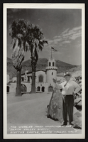
Postcard showing Scotty's Castle and Death Valley Scotty, Death Valley, California, circa mid 1900s
Date
Archival Collection
Description
Image
Home Notes: the Ideal Paper for the Ideal Home, vol. 525, no. 1626. London: Newnes & Pearson Publishing Co., 1925 March 07
Level of Description
Archival Collection
Collection Name: Mavis Eggle "Books as They Were Bought" Collection
Box/Folder: Box 30
Archival Component

Original plat, townsite of Las Vegas, Lincoln Co., Nevada, January 13, 1905
Date
Description
Subtitle: 'Embracing the N. 1/2 of S.W. 1/4 Sec. 27 Township 20S. R.61E. Mt. Diablo Meridian.' 'Book 1, page 17A" handwritten in lower right corner. Signed by Henry Lee, County Recorder, Lincoln County Nevada. 'Filed at request of J.T. Williams, January 13th A.D. 1905.' Backwards handwriting on right side. Map has a Lincoln County seal on the bottom near the center. In the dedication J.T. McWilliams states that he has surveyed and platted the townsite of Las Vegas subject to the right of way of the San Pedro, Los Angeles and Salt Lake Railroad Company. He signed the dedication on Jan. 13, 1905, and it was signed by witnesses Scale [ca. 1:2,520? 1 inch to approx. 210 feet?]. Copy of a blueline print.
Image
People picnicking in the desert. Handwritten inscription given with photograph: "Aunt Alma, Earl, Mother, Floyd, Bessie, Alley Lawson": photographic print, approximately 1915 to 1925
Level of Description
Archival Collection
Collection Name: Leon Rockwell Photograph Collection
Box/Folder: Folder 10
Archival Component

Map of Las Vegas Valley, Clark County, Nevada, 1954
Date
Description
Image
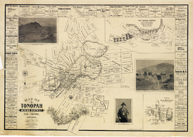
Map of Tonopah Mining District, Nye County, Nevada, 1902
Date
Description
Text

Postcard of Queen of Hearts playing card with a beach scene as the background, Atlantic City (N.J.), approximately 1900s-1980s
Date
Archival Collection
Description
Image

Plat showing original townsite and subdivisions, Las Vegas, Lincoln County, Nevada, May 1905
Date
Description
Land owned by the San Pedro, Los Angeles & Salt Lake Railroad is outlined. Scale: [ca. 1:12,000]. 1 inch = 1,000 feet. Cadastral map. Blueline print. Additional copy available in the J.T. McWilliams manuscript collection
Image