Search Results
"El Juego de la Oca" game, Mexico: Imprenta Vanegas Arroyo, approximately 1900
Level of Description
Archival Collection
Collection Name: UNLV Libraries Collection of Spanish Broadsides
Box/Folder: Oversized Box SH-081 (Restrictions apply)
Archival Component
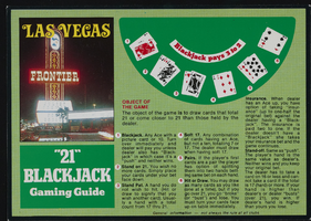
Postcard of gaming guide to blackjack showcasing the Frontier Hotel, Las Vegas (Nev.), approximately 1900s-1980s
Date
Archival Collection
Description
Image

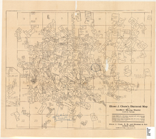
Tonopah, Nevada mining map, March 1904
Date
Description
Text
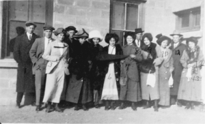
Film transparency of group standing outside of a building, presumably in Las Vegas, circa early 1900s
Date
Archival Collection
Description
Image
First schoolhouse in Las Vegas located at 2nd and Lewis streets, approximately 1900-1910
Level of Description
Archival Collection
Collection Name: Helen J. Stewart Photographs
Box/Folder: Oversized Box SH-060
Archival Component
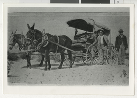
Photograph of Jim Ladd and an unidentified man standing next to a buckboard wagon, Boulder City (Nev.), early 1900s
Date
Archival Collection
Description
Image
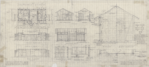
Architectural drawings of rest rooms at Zion National Park, Utah, floor plan, elevations, sections and details, December 12, 1925
Date
Archival Collection
Description
Floor plan, elevations, sections and details of rest room building at Zion National Park, Utah, as constructed. Sheet 1, Job no. 351, date 12/12/25, rev. 1/10/26. "Revised April 9, 1930. Drawing made as constructed." "Recommended by D. R. Hull per T.C. Unit, Landscape Eng. N.P.S. Approved by Stephen T. Mather, Director, N.P.S." Scale: 3/4"=1'-0". "Dr. by A.P.B. Tr. by Brown. Ch. by P.R. Gage."
Site Name: Zion National Park (Utah)
Image
Original documents, correspondence, and paper materials related to Schuyler family history, approximately 1900 to 2024
Level of Description
Archival Collection
Collection Name: Schuyler Family Photograph Collection
Box/Folder: Box 01, Box 02, Box 03, Box 04, Box 05, Box 06
Archival Component
Charles S. Sprague and Benjamin Gill Papers on Nevada Mining
Identifier
Abstract
The Charles S. Sprague and Benjamin Gill Papers on Nevada Mining (1904-1925) are comprised of various records from the mining companies owned and operated by businessmen Charles S. Sprague and Benjamin Gill who were active in the central Nevada boomtowns of Goldfield and Tonopah in the early twentieth century. Documents include correspondence, receipts and invoices, detailed records and copies of government legislative bills relating to the mining industry, and other business correspondence. Sprague's collection consists of his mining business correspondence dating from 1906 to 1925. Gill's papers are comprised of his business correspondence from 1916 to 1922.
Archival Collection
Map of the Goldfield Mining District, Goldfield, Nevada, 1907
Date
Description
Image