Search Results
Menu for the public banquet to His Excellency Sir Chihchen Lofengluh, K.C.V.O., envoy extraordinary and Chinese Minister plenipotentiary to the Court of St. James, South Western Hotel, 1900 January 12
Level of Description
Item
Archival Collection
Bohn-Bettoni Menu Collection
To request this item in person:
Collection Number: MS-00793
Collection Name: Bohn-Bettoni Menu Collection
Box/Folder: Box 02
Collection Name: Bohn-Bettoni Menu Collection
Box/Folder: Box 02
Archival Component

Map showing U.S. Bureau of Reclamation Region 3 projects in Arizona, California, Nevada, New Mexico and Utah, September 1967
Date
1967-09
Description
'United States, Department of the Interior, Stewart L. Udall, Secretary. Bureau of Reclamation, Floyd E. Dominy, Commissioner.' 'Map. No. X-300-738. September 1967.' Scale [ca. 1:1,774,080] (W 119°--W 108°/N 39°--N 32°). Relief shown pictorially. Shows completed, under construction and proposed dams and reservoirs, canals, and aqueducts, power plants, pumping plants, substations, transmission lines, tunnels and siphons. Also shows non-Bureau of Reclamation dams, reservoirs, tunnels, pipelines and irrigated lands. Includes inset map of location of Region 3 and key map of drainage basins. Bureau of Reclamation, [Region 3?].
Image
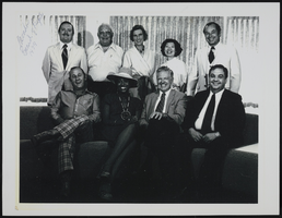
University of Nevada Board of Regents: photographic print
Date
1979
Archival Collection
Description
From the UNLV Libraries Single Item Accession Photograph Collection (PH-00171). University of Nevada Board of Regents. Back row, L-R: John Tom Ross, Louis Lombardi, Molly Knudtsen, Lily Fong, James "Bucky" Buchanan. Front row, L-R: Robert Cashell, Brenda Mason, John McBride, Chris Karamanos.
Image
Children sitting in front of their school house. Back row: John Francis and Effa Francis; middle row: Pearl Francis, Louise Fogliani, and Olympia Fogliani; front row: Jack Fogliani, David Francis, and William Francis (identified from left to right): Spring Valley, Nevada: photograph, approximately 1900 to 1909
Level of Description
Item
Archival Collection
Pearl Francis Neeley Photograph Collection
To request this item in person:
Collection Number: PH-00091
Collection Name: Pearl Francis Neeley Photograph Collection
Box/Folder: Digital File 00
Collection Name: Pearl Francis Neeley Photograph Collection
Box/Folder: Digital File 00
Archival Component
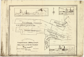
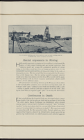
Map of properties in the Tonopah Mining District, Nye County, Nevada, circa 1901
Date
1897 to 1905
Description
'Surveyed by S.K. Bradford, U.S. Deputy.' 'May Bradford, Draughtsman.' Includes locations of mines and their main shafts and drawings of the hoists of the Tonopah Extension, Golden Anchor and the Red Rock Consolidated. Scale [ca. 1:2,400] 1 in. to 200 feet.
Image
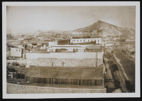
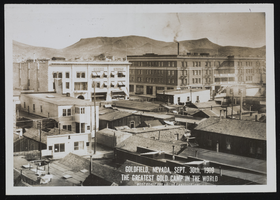
Goldfield and Tonopah, Nevada: photographic prints
Date
1900 to 1902
Archival Collection
Description
From the Nevada Mining Photograph Collection (PH-00361).
Image
Goldfield and Tonopah, Nevada: photographic prints
Date
1900 to 1902
Archival Collection
Description
From the Nevada Mining Photograph Collection (PH-00361).
Image

Diamond Jim's Nevada Club located in Las Vegas, Nevada: postcards
Date
1900 (year approximate) to 1999 (year approximate)
Archival Collection
Description
From the UNLV Libraries Single Item Accession Photograph Collection (PH-00171)
Image
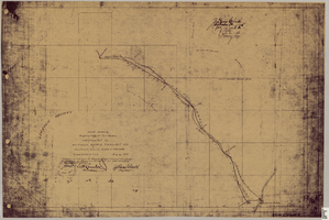
Map showing right of way of toll road constructed by Nevada Rapid Transit Co. in Lincoln County, State of Nevada
Date
1905-08-10
Description
Shows right of way of what now is Interstate 95 through what is now Clark County, Nevada. 'Aug. 10, 1905.' 'Adopted as toll road of Nevada Rapid Transit Company at meeting of Board of Directors of said company Aug. 25th, 1905. Attest W.H. Comstock, secretary, J. Ross Clark, president.' 'Book I, page 3'--Lower right corner. '... No. ... Recorded at ... [signed] J. Ross Clark ... September 1st A.D. 1905 at 40 ... past 8 A.M. to Book of Platts, Pages ... Lincoln Co. Nev. Record ... [signed] Henry Lee ...'--upper right portion of map. Seal of the Nevada Rapid Transit Company in lower left portion of map. Scale [ca. 126,720]. 1 in.=2 miles 1 map. Blueline print.
Image