Search Results
Unidentified man with dog wearing a pack, labeled "Goldfields' Lighting Express in the early days": postcard, approximately 1900-1905
Level of Description
Item
Archival Collection
C. A. Earle Rinker Photograph Collection of Goldfield, Nevada
To request this item in person:
Collection Number: PH-00350
Collection Name: C. A. Earle Rinker Photograph Collection of Goldfield, Nevada
Box/Folder: Folder 03
Collection Name: C. A. Earle Rinker Photograph Collection of Goldfield, Nevada
Box/Folder: Folder 03
Archival Component
Portrait of Death Valley Scotty, labeled "Scotty the Desert Mystery." There is a handwritten message on back: postcard, approximately 1900-1905
Level of Description
Item
Archival Collection
C. A. Earle Rinker Photograph Collection of Goldfield, Nevada
To request this item in person:
Collection Number: PH-00350
Collection Name: C. A. Earle Rinker Photograph Collection of Goldfield, Nevada
Box/Folder: Folder 04
Collection Name: C. A. Earle Rinker Photograph Collection of Goldfield, Nevada
Box/Folder: Folder 04
Archival Component

Blueprint showing proposed pipeline for gravity water supply at Las Vegas, Nevada, February 16, 1905
Date
1905-02-16
Description
'Office of Chief Engineer, Los Angeles, Cal., Feb. 16, 1905.' '2-18-17' hand-printed in lower right corner. Proposed pipeline is printed in red. Scale [1:6,000]. 1 inch to 500 feet. San Pedro, Los Angeles & Salt Lake Railroad Company. Office of Chief Engineer
Image
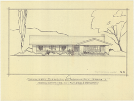
Architectural drawing of residential home in Boulder City, Nevada, preliminary elevation, 1962
Date
1962
Archival Collection
Description
Preliminary drawing of front exterior elevation of a ranch-style residential home in Boulder City, Nevada.
Architecture Period: Mid-Century ModernistImage
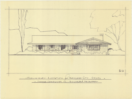
Architectural drawing of residential home in Boulder City, Nevada, preliminary elevation, 1962
Date
1962
Archival Collection
Description
Preliminary drawing of front exterior elevation of a ranch-style residential home in Boulder City, Nevada.
Architecture Period: Mid-Century ModernistImage
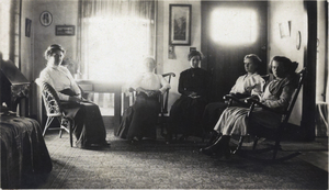
Photograph of Julia Russell, Mrs. Worrell, Grace Worrell, Olive Lake, and Wanda Bell, circa 1900s-1930s
Date
1900 to 1930
Archival Collection
Description
Black and white image of women including Julia Russell, Mrs. Worrell, Grace Worrell, Olive Lake, and Wanda Ball. Grace Worrell was a Sunday School Teacher.
Image
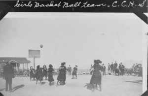
Film transparency of the girls basketball team for Clark County High School, Las Vegas, circa early 1900s
Date
1900 to 1920
Archival Collection
Description
Black and white image of the girls basketball team for Clark County High School playing a game of basketball, per the handwritten description above the image. Note: Image is from a family photo album that was loaned to UNLV Libraries Special Collections and returned to the family on July 17, 1984.
Image

Map of Ely Range Quadrangle, Lincoln County, Nevada, 1921
Date
1921
Description
'Edition of 1921.' 'W. H. Herron, Acting Chief Geographer; Geo. R. Davis, Geographer In Charge; Topography by H. H. Hodgeson, N. E. Ballmer, and W. B. Upton, Jr.; Control by H. H. Hodgeson, Roscoe Reeves, and D. S. Birkett. Surveyed in 1916.' At top of map: ' Topography, State of Nevada.' At upper left corner: ' Department of the Interior, Albert B. Fall, Secretary; U.S. Geological Survey, George Otis Smith, Director.' Southern Nevada Mining Map Collection. 15 minute series (topographic) Nevada.
Image
Haller, Linda L. The Business of Betting: Proposals for Reforming the Taxation of Business Gamblers, Tax Lawyer 38(4), approximately 1900 to 1999
Level of Description
File
Archival Collection
UNLV Libraries Collection of Articles on Gaming and Las Vegas, Nevada Topics
To request this item in person:
Collection Number: MS-00626
Collection Name: UNLV Libraries Collection of Articles on Gaming and Las Vegas, Nevada Topics
Box/Folder: Box 17
Collection Name: UNLV Libraries Collection of Articles on Gaming and Las Vegas, Nevada Topics
Box/Folder: Box 17
Archival Component
Joseph, Richard. Las Vegas is the place where the action is not governed by the clock, Magazine for Men 58(4), approximately 1900 to 1999
Level of Description
File
Archival Collection
UNLV Libraries Collection of Articles on Gaming and Las Vegas, Nevada Topics
To request this item in person:
Collection Number: MS-00626
Collection Name: UNLV Libraries Collection of Articles on Gaming and Las Vegas, Nevada Topics
Box/Folder: Box 13
Collection Name: UNLV Libraries Collection of Articles on Gaming and Las Vegas, Nevada Topics
Box/Folder: Box 13
Archival Component