Search Results
Boomtown Hotel and Casino, image 003: postcard, approximately 1994
Level of Description
Item
Archival Collection
Dennis McBride Photograph Collection
Archival Component
Boomtown Hotel and Casino, image 004: postcard, approximately 1997
Level of Description
Item
Archival Collection
Dennis McBride Photograph Collection
Archival Component
Boomtown news reports and Securities and Exchange Commission filings, 1994-1997
Level of Description
File
Archival Collection
Eugene Martin Christiansen Papers
Archival Component
Boomtown, Inc.: newspaper articles, gaming license data, and correspondence, 1980-1987
Level of Description
File
Archival Collection
Gary W. Royer Collection on Gaming
Archival Component
Boomtown Reno: renderings and sketches of sections, elevations, and exterior and interior building perspectives, 2009
Level of Description
File
Archival Collection
Bergman Walls & Associates Architectural Drawings
Archival Component
Boomtown, Inc.: annual reports, prospectus, advertisements, and Smith Barney stock reports, 1992-1996
Level of Description
File
Archival Collection
Gary W. Royer Collection on Gaming
Archival Component
Regional Transportation Commission of Clark County, Nevada Planning Division: "Citizens Area Transport (CAT) Proposed Boomtown Extension" (Draft), 1994 September
Level of Description
File
Archival Collection
Bruce Turner Collection on Transportation and Water in Southern Nevada
Archival Component
"The Real Las Vegas" documentary by A & E, volume I "Boomtown," volume II "Gamble in the Desert," volume III "Tarnished Dream," and volume IV "House of Cards" video recordings, 1996
Level of Description
File
Archival Collection
Gary W. Royer Collection on Gaming
Archival Component
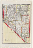
Map of Nevada, circa 1909
Date
1907 to 1911
Description
'Geo. F. Cram, engraver and publisher.' Scale [ca. 1:1,584,000. 1 in. to approx. 25 miles] (W 120°--W 114°/N 42°--N 35°). Relief shown by hachures and spot heights. Counties outlined in color. Shows railroads, forest reserves, mines, Indian reservations, and springs. Shows range and township grid. Indexes on verso to both Nevada and Utah maps. Atlas p. numbers in right margin: 124-125. G.F. Cram.
Text
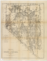
Map of Nevada, 1876
Date
1876
Description
'Compiled from the official records of the General Land Office and other sources by C. Roeser, principal draughtsman, G.L.O. Photo-lith & print. by Julius Bien, 16 & 18 Park Place, N.Y.' 'Department of the Interior, General Land Office, J.A. Williamson, Commissioner.' Scale [1:1,013,760]. 1 in. to 16 miles (W 120°--W 114°/N 42°--N 35°) .Relief shown by hachures. Shows township and range grid. Department of the Interior, General Land Office.
Image