
Search the Special Collections and Archives Portal

Search Results

Display    Results Per Page
Displaying results 171 - 180 of 576778

Charles S. Sprague and Benjamin Gill Papers on Nevada Mining

Identifier

MS-00570

Abstract

The Charles S. Sprague and Benjamin Gill Papers on Nevada Mining (1904-1925) are comprised of various records from the mining companies owned and operated by businessmen Charles S. Sprague and Benjamin Gill who were active in the central Nevada boomtowns of Goldfield and Tonopah in the early twentieth century. Documents include correspondence, receipts and invoices, detailed records and copies of government legislative bills relating to the mining industry, and other business correspondence. Sprague's collection consists of his mining business correspondence dating from 1906 to 1925. Gill's papers are comprised of his business correspondence from 1916 to 1922.

Archival Collection

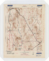
Topographic map of the Camp Mohave quadrangle in California, Nevada and Arizona, 1942

Date

1942

Description

Scale 1;250,000 ; polyconic projection (W 115°--W 114V/N 36V--N 35V) ; 1 map : col. ; 52 x 37 cm ; Relief shown by contours and spot heights. Contour interval 250 feet ; "Training map"--Center of upper margin of map ; "Base compiled from U.S. Geological Survey quadrangles. Control from U.S. Geological Survey. Revised from state highway maps for Arizona, Nevada and California" ; "Culture revisions shown in red based on reconnaissance by 67th Engr. Co. (Top.). May not be of same accuracy as base map." ; Map shows roads, trails, ponton sites, dam sites, possible air fields, possible landing fields, airports, water points, and impassable areas ; Map was originally restricted. "Classification cancelled by authority of Chief of Engineers letter of Jan. 22, 1946." ; Title at top of map: Nevada-Arizona-California : Camp Mohave quadrangle : grid zone F ; Army Map Service, U.S. Army.

Image

Map of California, territories of New Mexico, Arizona, Colorado, Nevada and Utah, circa 1863

Date

1861 to 1865

Description

40 x 62 cm. Relief shown by hachures and spot heights. Prime meridians: Greenwich and Washington. "Historical and statistical view of the United States, 1860"--Verso. Atlas page numbers at top: 58-59. Arizona became a territory in 1863, and Nevada became a state on October 31, 1864, so this map was either published in 1863 or in 1864 before the end of October. Original publisher: Johnson and Ward.

Image

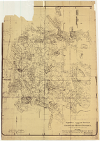
Map of approved mineral surveys in the Goldfield Mining District, Esmeralda and Nye Counties, Nevada, 1911

Date

1911

Description

'Compiled from records of the U.S. Surveyor General and other authentic sources by Davis and Byler, Mining Engineers, Goldfield, Nevada. Copyright 1908 by Davis and Byler. 1911.' Scale [ca. 1:9,600]. 1 in. to 800 feet. (W 117°14'--W 117°09'/N 37°46'--N 37°41'). Blueline print. Includes township and range grid. Library's copy has upper-left corner torn off and has circles drawn around and diagonal lines drawn on certain claims.

Image

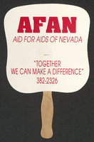
Aid for AIDS of Nevada fan

Date

1990 (year approximate) to 1999 (year approximate)

Description

From the Dennis McBride Collection on LGBTQ Las Vegas, Nevada (MS-00802) -- Alphabetical research files -- AIDS: Organizations: Aid for AIDS of Nevada (AFAN) file.

Text

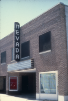
Slide of the Nevada Theater, Wells, Nevada, 1986

Date

1986

Description

An image of the Nevada Theater located in Wells. The black and white neon sign located above the entrance doors to the building reads: "Nevada." Site Name: Nevada Theater (Wells, Nev.)

Image

Slide of Nevada Club, Ely, Nevada, 1986

Date

1986

Description

An image of the exterior of the Nevada Club and Hotel Nevada in Ely. Mounted onto the brick building and hanging over the club's entrance is a large sign of a miner with a pickaxe. Various neon signs read: "Welcome, 21 Slots & Food, Dancing;" "Hotel Nevada;" "Free Parking;" and "Nevada Club."

Image

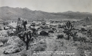
Postcard showing Searchlight, Nevada, circa 1930s

Date

1930 to 1939

Archival Collection

Description

The view of the small town of Searchlight, Nevada. Formed in 1897, Searchlight is an old boomtown that was made popular when George Frederick Colton discovered gold at the location where the town is now built. Unnamed buildings cluster together in the center of the postcard while rocky terrain decorated with small shrubs and mines surround the city's outskirts. Transcribed onto the bottom of the postcard: "Searchlight, Nevada; Duplex Mine In Foreground." The Frasher's Foto logo is also printed onto the bottom right corner.

Image

Map of California, Nevada, Utah, Colorado, Arizona & New Mexico, circa 1867

Date

1865 to 1869

Description

39 x 62 cm. Relief shown by hachures and spot heights. Prime meridian: Greenwich and Washington. Hand colored. Shows natural features, populated places, routes of mail steamships, routes of explorers, locations of Indian tribes, railroad routes, and proposed railroad routes. In top margin: No. 80-81. On verso: New Mexico, Arizona, Colorado, Idaho, Dakota (statistics and other information) and The state of California (statistics and other information). Original publisher: G.W. and C.B. Colton.

Image

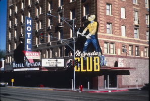
Hotel Nevada billboard, Ely, Nevada

Date

2016 (year approximate) to 2020 (year approximate)

Description

View of the Hotel Nevada billboard reading "Hotel Nevada Western Hospitality."

501 E Aultman St, Ely, NV 89301


Image