Search Results
Lake Mead, Nevada photographs, 1930-1959
Level of Description
Scope and Contents
Materials contain photographic prints, photographic slides, and photographic negatives that depict Lake Mead from 1930 to 1959. The photographs primarily depict people engaged in recreational activities on or around Lake Mead, including fishing, swimming, and boating. The photographs also depict some of the canyons that Lake Mead touches, including the Grand Canyon, Iceberg Canyon, Black Canyon, Boulder Canyon, and Quartermaster Canyon. Also included in the photographs is the lookout point near the shores of Lake Mead where the dedication plaque for Dr. Elwood Mead, the lake's namesake and former head of the Bureau of Reclamation, is installed.
Archival Collection
Collection Name: L. F. Manis Photograph Collection
Box/Folder: N/A
Archival Component
Early Las Vegas, Nevada, 1876-1964
Level of Description
Scope and Contents
Materials contain photographs of the Kiel (Taylor) Ranch (one of the earliest non-indigenous settlements in the Las Vegas Valley), Gilcrease Ranch, and events and locations in Clark County from 1876 to 1964. The materials include photographs of Fremont Street and other Las Vegas landmarks, schools in Las Vegas, the Mormon Fort (the oldest non-indigenous settlement in the Las Vegas Valley), banks, parades, downtown Las Vegas, and the Helldorado Days parade.
Archival Collection
Collection Name: Elbert Edwards Photograph Collection
Box/Folder: N/A
Archival Component
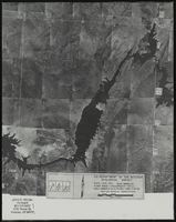
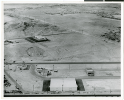
Aerial view of the Bonelli quadrant in Arizona-Nevada: photographic print
Date
Archival Collection
Description
Image
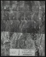
Aerial view of the Bonelli quadrant in Arizona-Nevada: photographic print
Date
Archival Collection
Description
Image
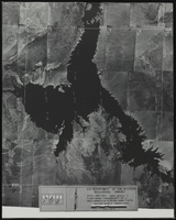
Aerial view of the Bonelli quadrant in Arizona-Nevada: photographic print
Date
Archival Collection
Description
Image
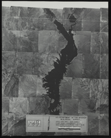
Aerial view of the Bonelli quadrant in Arizona-Nevada: photographic print
Date
Archival Collection
Description
Image
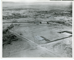
Aerial photograph of North Las Vegas, Nevada, June 5, 1973
Date
Archival Collection
Description
Image
Aerial photograph of North Las Vegas, Nevada, June 5, 1973
Date
Archival Collection
Description
Image
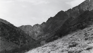
One of the side canyons in the Twin River area, Nevada: photographic print
Date
Archival Collection
Description
From the Nye County, Nevada Photograph Collection (PH-00221) -- Series V. Smoky Valley, Nevada and Round Mountain, Nevada -- Subseries V.A. Carver, Carver-Duhme, and Carver-Book Families (Smoky Valley)
Image
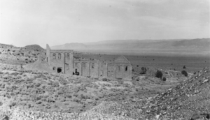
Remains of the Combination Mill located east of Belmont, Nevada: photographic print
Date
Archival Collection
Description
From the Nye County, Nevada Photograph Collection (PH-00221) -- Series V. Smoky Valley, Nevada and Round Mountain, Nevada -- Subseries V.A. Carver, Carver-Duhme, and Carver-Book Families (Smoky Valley)
Image