Search Results
Nevada Nurses Association Records
Identifier
Abstract
Collection is comprised of the organizational records of the Nevada Nurses Association dating from 1945 through 1995. Topics addressed by the material include Planned Parenthood, state legislature on health care, the Equal Rights Amendment (ERA), and League of Women Voters. Types of material in the collection include clippings, association history, membership information, receipts, correspondence, convention notes and programs, alumni directory, newsletters, pamphlets, meeting minutes, and scrapbooks.
Archival Collection
Nevada Association of Psychiatric Physicians Records
Identifier
Abstract
The records of the Nevada Association of Psychiatric Physicians (NAPP) document the professional association's membership, activities, and advocacy from 1984 to 2000. The records indicate how NAPP organized the professional psychiatric community in Southern Nevada, held meetings on various public health initiatives, networked with other professional organizations like the American Medical Association and the American Psychological Association, and published articles and newsletters on a variety of psychiatric topics.
Archival Collection
Nevada State Treasurer Annual Reports
Identifier
Abstract
The Nevada State Treasurer Annual Reports contain annual reports from the Office of the State Treasurer from 1867 to 1985. The collection of reports is not comprehensive; there are many gaps in the date ranges.
Archival Collection

Map showing U.S. Bureau of Reclamation Region 3 projects in Arizona, California, Nevada, New Mexico and Utah, September 1967
Date
Description
Image
Nevada Women's History Project Records
Identifier
Abstract
The Nevada Women's History Project Records (1995-2008) contain the early organizational records of the Nevada Women's History Project (NWHP), which was created to collect and disseminate information about women throughout Nevada's history. The collection reflects the early organization of the Nevada Women's History Project's (NWHP) Southern region and the variety of events and projects with which the organization was involved with across the state of Nevada. Materials include membership lists, meeting minutes, press releases, project files, and NWHP newsletters.
Archival Collection
Nevada Chili Boosters and Nevada Association for the Handicapped Chili Cookoff Records
Identifier
Abstract
Records are comprised of meeting minutes, newsletters, and event planning communication produced by the Nevada Chili Boosters in conjunction with the Nevada Association for the Handicapped between 1988 and 1998. The records provide information about the Chili Boosters "Hot Pot Chili Cookoff" benefiting the Nevada Association for the Handicapped and other charities.
Archival Collection
Nevada and Las Vegas, Nevada Maps and Tourism Ephemera [UNPROCESSED]
Identifier
Abstract
This collection is unprocessed. See Access Note for more information. The Nevada and Las Vegas, Nevada Maps and Tourism Ephemera collection (1871-2019) consists of five boxes of Nevada and Las Vegas maps and two boxes of Nevada travel and tourism ephemera.
Archival Collection
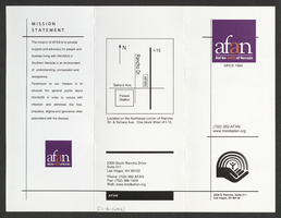
Aid for AIDS of Nevada services brochure
Date
Archival Collection
Description
Text