Search Results
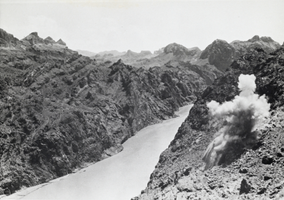
Photograph of Boulder Canyon near Boulder City, Nevada, 1931
Date
1931
Archival Collection
Description
A view of the Colorado River passing through a part of Boulder Canyon. The blast visible at top right of canyon was conducted near Boulder City, Nevada.
Image
Aerial view of the Bonelli quadrant in Arizona-Nevada: photographic print
Date
1950
Archival Collection
Description
From the Army Mapping Service Aerial Photographs of Southern and Western Nevada (PH-00285). Aerial photographs, composites, and indices. Aerial photographs, Quad. Bonelli 4, U.S. Department of the Interior Geological Survey, Army Map Service. State: Arizona - Nevada. Flight Scale I-47200Project-GS-LJ. Index copied -8-26-50. Flying Comp. -7-26-50
Image

Aerial view of the Bonelli quadrant in Arizona-Nevada: photographic print
Date
1950
Archival Collection
Description
From the Army Mapping Service Aerial Photographs of Southern and Western Nevada (PH-00285). Aerial photographs, composites, and indices. High altitude aerial photographs, Quad. Bonelli, State: Arizona - Nevada. U.S. Geological Survey, Army Map Service. Flight Scale I-47200Project-GS-LJ. Index copied -8-26-50. Flying Comp. -7-26-50
Image
Aerial view of the Bonelli quadrant in Arizona-Nevada: photographic print
Date
1952
Archival Collection
Description
From the Army Mapping Service Aerial Photographs of Southern and Western Nevada (PH-00285). Aerial photographs, composites, and indices. High altitude aerial photographs, Quad. Bonelli 3, State: Arizona - Nevada. U.S. Geological Survey, Army Map Service. Flight Scale I-47200Project-GS-LJ. Index copied -8-26-50. Flying Comp. -7-26-50
Image
Aerial view of the Bonelli quadrant in Arizona-Nevada: photographic print
Date
1950
Archival Collection
Description
From the Army Mapping Service Aerial Photographs of Southern and Western Nevada (PH-00285). Aerial photographs, composites, and indices. High altitude aerial photographs, Quad. Bonelli, State: Arizona - Nevada. U.S. Geological Survey, Army Map Service. Flight Scale I-47200Project-GS-LJ. Index copied -8-26-50. Flying Comp. -7-26-50
Image
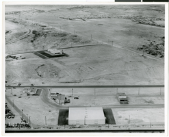
Aerial photograph of North Las Vegas, Nevada, June 5, 1973
Date
1973-06-05
Archival Collection
Description
Aerial view of housing developments in North Las Vegas, Nevada. Handwritten on back of photograph: "Regal Estates. Losee Road, Crestline Loop."
Image
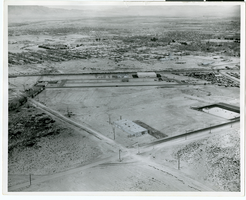
Aerial photograph of North Las Vegas, Nevada, June 5, 1973
Date
1973-06-05
Archival Collection
Description
Aerial view of housing developments in North Las Vegas, Nevada. Handwritten on back of photograph: "Losee Road-Crestline Loop. Miller underpass."
Image

Artistic rendition of Club Row on Virginia Street in Reno, Nevada
Date
1958-06-08
Archival Collection
Description
From Harvey's Hotel and Casino Postcard Collection (PH-00367). Club Row Virginia Street in Reno, Nevada. The postcard is addressed to Mrs. H. B. Palmer.
Image
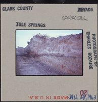
Photographic slide of a trench at Tule Springs, Nevada, January 28, 1963
Date
1963-01-28
Archival Collection
Description
A trench at Tule Springs, Nevada.
Image
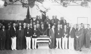
Initiation night at the Elks' Hall, Goldfield, Nevada: photographic print
Date
1937 to 1938
Archival Collection
Description
From the Nye County, Nevada Photograph Collection (PH-00221) -- Series VI. Tonopah, Nevada -- Subseries VI.A. Bradshaw Family (Goldfield-Tonopah). Among those pictured are Ed Kitchen, Albert Bradshaw, Bill Barrow, A.N. Bradshaw, Dr. J.C. Cherry, John Koontz, John O’Leary, Doc Galvin, Leonard Traynor, and Mr. Sutherland.
Image