Search Results
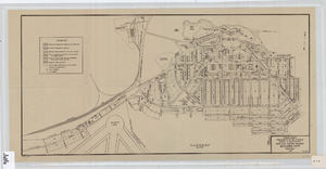
Cadastral map of Boulder City, Nevada, 1940
Date
Description
Image
George Mortimer Photograph Album of Searchlight, Nevada
Identifier
Abstract
The George Mortimer Photograph Album of Searchlight, Nevada dates between approximately 1900 and 1910, and contains black-and-white photographic prints illustrating various scenes and individuals in Searchlight, Nevada. Some images are captioned with initials or brief names.
Archival Collection
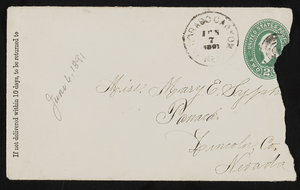
Letter and envelope from John M. Bunker, Eldorado Canyon, Nevada to Mary Etta Syphus, Panaca, Nevada
Date
Archival Collection
Description
From the Syphus-Bunker Papers (MS-00169). The folder contains an original handwritten letter, an envelope, a typed transcription of the same letter, and a copy of original letter attached.
Text
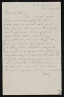
Letter from May [?], Bunkerville, Nevada to John M. Bunker, Eldorado Canyon, Nevada
Date
Archival Collection
Description
From the Syphus-Bunker Papers (MS-00169). The folder contains an original handwritten letter and a typed transcription of the same letter, and a copy of the original letter. Letter does not state May's last name but she seems to be the brother of John M. Bunker.
Text
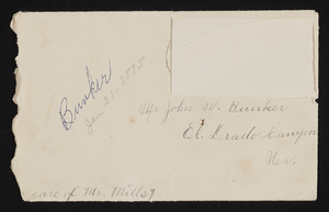
Letter and envelope from May [Bunker?]. Bunkerville, Nevada to John M. Bunker Eldorado Canyon, Nevada
Date
Archival Collection
Description
From the Syphus-Bunker Papers (MS-00169). The folder contains an original handwritten letter, a typed transcription of the same letter, the original envelope with the stamp removed, and a copy of the original letter.
Text
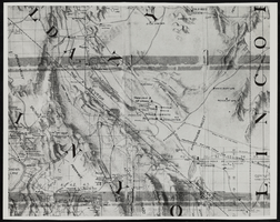
Topographic map of Nevada and California: map
Date
Description
Image

Topographic map of groundwater in the southwest quadrangle of Las Vegas, Nevada, 1985
Date
Description
Text
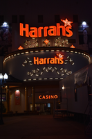
Harrah's marquee sign, Reno, Nevada
Date
Archival Collection
Description
View of the marquee sign for Harrah's Hotel and Casino in Reno. The business was closed in early 2020.
219 North Center Street, Reno, Nevada, 89501
Image
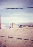
Holding cells for Nevada Test Site protestors: photographic print
Date
Archival Collection
Description
Image
University of Nevada, Las Vegas (UNLV) 29th commencement program
Date
Archival Collection
Description
Commencement program from University of Nevada, Las Vegas Commencement Programs and Graduation Lists (UA-00115).
Text