Search Results
Industry, Nevada (Nevada Business Review). Contains newsletter, 1969 December to 1970 May
Level of Description
File
Archival Collection
Howard Cannon Papers
To request this item in person:
Collection Number: MS-00002
Collection Name: Howard Cannon Papers
Box/Folder: Box 28 (91st Session)
Collection Name: Howard Cannon Papers
Box/Folder: Box 28 (91st Session)
Archival Component
State of Nevada - Nevada Test Site - Nuclear Tests, 1977 December to 1978 September
Level of Description
File
Archival Collection
Howard Cannon Papers
To request this item in person:
Collection Number: MS-00002
Collection Name: Howard Cannon Papers
Box/Folder: Box 25 (95th Session)
Collection Name: Howard Cannon Papers
Box/Folder: Box 25 (95th Session)
Archival Component
State of Nevada - Nevada Test Site - Utilization of NTS, 1977 November to 1978 May
Level of Description
File
Archival Collection
Howard Cannon Papers
To request this item in person:
Collection Number: MS-00002
Collection Name: Howard Cannon Papers
Box/Folder: Box 25 (95th Session)
Collection Name: Howard Cannon Papers
Box/Folder: Box 25 (95th Session)
Archival Component
State of Nevada. Nevada Power Company. Contains correspondence, papers and memos, 1982 August
Level of Description
File
Archival Collection
Howard Cannon Papers
To request this item in person:
Collection Number: MS-00002
Collection Name: Howard Cannon Papers
Box/Folder: Box 74 (97th Session)
Collection Name: Howard Cannon Papers
Box/Folder: Box 74 (97th Session)
Archival Component
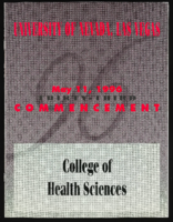
University of Nevada, Las Vegas (UNLV) College of Health Sciences 33rd commencement program
Date
1996-05-11
Archival Collection
Description
Commencement program from University of Nevada, Las Vegas Commencement Programs and Graduation Lists (UA-00115).
Text
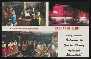
The Exchange Club in Beatty, Nevada: postcard
Date
1940 (year approximate) to 1990 (year approximate)
Archival Collection
Description
From the Harvey's Hotel and Casino Postcard Collection (PH-00367) -- The Exchange Club in the colorful "old west" town of Beatty, Nevada, is a 3-way fun, food, and refreshment stop with its popular casino and bar and the adjoining family restaurant, the Amargosa Grill. In the center of Beatty, the Exchange Club is between Tonopah and Las Vegas and at the Eastern gateway into Death Valley National Monument.
Image
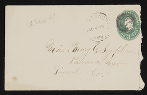
Letter and envelope from John M Bunker, St. Thomas, Nevada to Mary Etta Syphus, Panaca, Nevada
Date
1894-12-02
Archival Collection
Description
From the Syphus-Bunker Papers (MS-00169). The folder contains an original handwritten letter, an envelope, a typed transcription of the same letter, and a copy of original letter attached.
Text
Southern Nevada Telephone Company office, Las Vegas, Nevada, photograph and negative, 1930
Level of Description
File
Archival Collection
Elton and Madelaine Garrett Photograph and Architectural Drawing Collection
To request this item in person:
Collection Number: PH-00265
Collection Name: Elton and Madelaine Garrett Photograph and Architectural Drawing Collection
Box/Folder: Folder 09, Box 19
Collection Name: Elton and Madelaine Garrett Photograph and Architectural Drawing Collection
Box/Folder: Folder 09, Box 19
Archival Component
Industry, Nevada (Nevada Business Review). Contains newsletter, 1969 February to 1969 November
Level of Description
File
Archival Collection
Howard Cannon Papers
To request this item in person:
Collection Number: MS-00002
Collection Name: Howard Cannon Papers
Box/Folder: Box 28 (91st Session)
Collection Name: Howard Cannon Papers
Box/Folder: Box 28 (91st Session)
Archival Component
State of Nevada. Nevada Bar. Contains correspondence and papers, 1981 June to 1981 October
Level of Description
File
Archival Collection
Howard Cannon Papers
To request this item in person:
Collection Number: MS-00002
Collection Name: Howard Cannon Papers
Box/Folder: Box 31 (97th Session)
Collection Name: Howard Cannon Papers
Box/Folder: Box 31 (97th Session)
Archival Component