Search Results
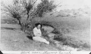
Film transparency of Olive Lake near Stewart Ranch, Las Vegas, circa early 1900s
Date
1904 to 1939
Archival Collection
Description
Black and white image of a woman (presumably Olive Lake-Eglington) sitting next to a creek, with accompanying handwritten description: "Olive-near Stewart Ranch." Site Name: Las Vegas Ranch (Las Vegas, Nev.)
Image
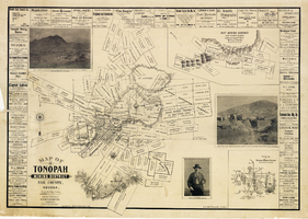
Map of Tonopah Mining District, Nye County, Nevada, 1902
Date
1902
Description
'Compiled and published by Booker & Bradford, engineers, Tonopah, Nevada.' 'Copyrighted by Booker & Bradford 1902.' 'Lith. Britton & Rey, S.F., Cal.' Relief shown by hachures. Includes insets of Ray Mining District, Nye County, Nevada, and Vicinity map of Tonopah Mining District, Nye County, Nevada. Includes advertisements and photographs of Tonopah ore, town of Tonopah, and of J.L. Butler, discoverer of the Mizpah Lode. Scale [ca. 1:7,200]. 1 inch to 600 feet. Mounted on linen.
Text
Unknown author. Beating the System in Las Vegas, Consumer Electorate Show Daily, approximately 1900 to 1999
Level of Description
File
Archival Collection
UNLV Libraries Collection of Articles on Gaming and Las Vegas, Nevada Topics
To request this item in person:
Collection Number: MS-00626
Collection Name: UNLV Libraries Collection of Articles on Gaming and Las Vegas, Nevada Topics
Box/Folder: Box 15
Collection Name: UNLV Libraries Collection of Articles on Gaming and Las Vegas, Nevada Topics
Box/Folder: Box 15
Archival Component
Unknown author. Beating the System in Las Vegas, Consumer Electronics Show Daily, approximately 1900 to 1999
Level of Description
File
Archival Collection
UNLV Libraries Collection of Articles on Gaming and Las Vegas, Nevada Topics
To request this item in person:
Collection Number: MS-00626
Collection Name: UNLV Libraries Collection of Articles on Gaming and Las Vegas, Nevada Topics
Box/Folder: Box 09
Collection Name: UNLV Libraries Collection of Articles on Gaming and Las Vegas, Nevada Topics
Box/Folder: Box 09
Archival Component
Unknown author. Las Vegas: Fast-Paced Gambling Town that Never Sleeps,, approximately 1900 to 1999
Level of Description
File
Archival Collection
UNLV Libraries Collection of Articles on Gaming and Las Vegas, Nevada Topics
To request this item in person:
Collection Number: MS-00626
Collection Name: UNLV Libraries Collection of Articles on Gaming and Las Vegas, Nevada Topics
Box/Folder: Box 14
Collection Name: UNLV Libraries Collection of Articles on Gaming and Las Vegas, Nevada Topics
Box/Folder: Box 14
Archival Component
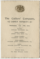
The Cutlers' Company ladies banquet, menu, Wednesday, July 18, 1900, The Hôtel Métropole, Whitehall Rooms
Date
1900-07-18
Archival Collection
Description
Note: Master: Edward Beaumont Menu insert: Toasts; Wine lists Restaurant: The Hôtel Métropole (London, England). Whitehall Rooms Location: London, England
Text
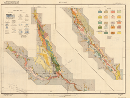
Soil map, Nevada, Moapa Valley sheet, 1923
Date
1923
Archival Collection
Description
'U.S. Department of Agriculture, Bureau of Chemistry and Soils; C.A. Browne, Acting Chief; Curtis F. Marbut, in charge, Soil Survey.' 'Macy H. Lapham, Inspector, District 5. Soils surveyed by F.O. Youngs, in charge, and E.J. Carpenter.' 'Field Operations, Bureau of Soils, 1923.' 'A, Hoen & Co. Lith. Baltimore, Md.' Shows township and range lines. Scale [1:63,360]. 1 in. = 1 mile (W 114°45´--W 114°18´/N 36°51´--N 36°24´). Library's copy has hand-written notes and has hand-drawn maps and notes on verso.
Image
Two white women and three Native American women, one of whom could be Maude Yount, seated on wicker chairs, possibly at Manse Ranch, Pahrump, Nevada, approximately 1900-1920
Level of Description
File
Archival Collection
O. J. Fisk Photographs
To request this item in person:
Collection Number: PH-00096
Collection Name: O. J. Fisk Photographs
Box/Folder: Folder 01
Collection Name: O. J. Fisk Photographs
Box/Folder: Folder 01
Archival Component
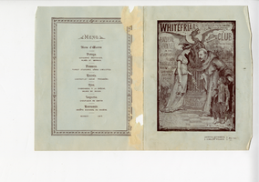
Whitefriars Club annual dinner, menu, Wednesday, January 24, 1900, Trocadero Restaurant, Empire Room
Date
1900-01-24
Archival Collection
Description
Note: Chair to be taken by Friar W. P. Treloar, Sheriff of London. "Friar Montagu, fecit [artist]" at bottom of cover illustration Menu insert: Music programs; Toasts Restaurant: Trocadero Restaurant Location: Piccadilly Circus, W., London, England
Text

Map of well locations, Las Vegas Valley, Nevada, 1975
Date
1976
Description
'Cartography by Marj Thielke.' 'Prepared in cooperation with the State of Nevada, Department of Conservation and Natural Resources, Division of Water Resources.' Relief shown by contours. Shows township and range lines. Originally published as Plate 1 in Water-level changes associated with ground-water development in Las Vegas Valley, Nevada, 1971-75 : fourth progress report--summary of data / by James R. Harrill, published in 1976 by the Department of Conservation and Natural Resources, Division of Water Resources, as volume 22 of Water resources-information series report. Scale [ca. 1:69,696. 1 in.=approx. 1.1 miles] (W 115°20´--W 115°00´/N 36°20´--N 36°00´).
Image