Search Results
Boyce's Uptown Des Moines Smartest Neighborhood Restaurant, menu, approximately 1900 to 1930
Level of Description
File
Archival Collection
UNLV University Libraries Menu Collection
To request this item in person:
Collection Number: MS-00436
Collection Name: UNLV University Libraries Menu Collection
Box/Folder: Box 109
Collection Name: UNLV University Libraries Menu Collection
Box/Folder: Box 109
Archival Component
Postcard showing Scotty's Castle in Death Valley, California, circa mid 1900s
Date
1920 to 1959
Archival Collection
Description
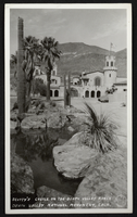
An image of Scotty's Castle in the desert terrain of Death Valley. Located within the far northern region of Death Valley in Grapevine Canyon, the Death Valley Ranch, more commonly known as Scotty's Castle, is a prime example of Spanish-Mediterranean styling during the Roaring 1920s and Depression of the 1930s. Scotty's Castle was constructed by Albert Johnson with the help of Death Valley Scotty during the Great Depression, but because the men began to build onto federal land, construction was forced to a halt. To this day, Scotty's Castle remains incomplete. Transcribed across the bottom of the image: "Scotty's Castle on the Death Valley Ranch; Death Valley National Monument, Calif."
Image
Schoolhouse at Bingham, Utah; asphaltene mine, Fort Duchesne, Utah; Utah valley, 1900
Level of Description
File
Archival Collection
Ferron and Bracken Photograph Collection
To request this item in person:
Collection Number: PH-00001
Collection Name: Ferron and Bracken Photograph Collection
Box/Folder: Oversized Box 11
Collection Name: Ferron and Bracken Photograph Collection
Box/Folder: Oversized Box 11
Archival Component
Belgian Royal Family residence, dinner for Their Belgian Majesties, menu, 1900 October 08
Level of Description
Item
Archival Collection
Bohn-Bettoni Menu Collection
To request this item in person:
Collection Number: MS-00793
Collection Name: Bohn-Bettoni Menu Collection
Box/Folder: Box 03
Collection Name: Bohn-Bettoni Menu Collection
Box/Folder: Box 03
Archival Component
Gold mine east of Las Vegas, Nevada, unidentified man and woman, William Beckley, Leva Beckley, unidentified man, and Jake Beckley (identified left to right on verso): photographic print, approximately 1915 to 1925
Level of Description
Item
Archival Collection
Beckley Family Photograph Collection
To request this item in person:
Collection Number: PH-00148
Collection Name: Beckley Family Photograph Collection
Box/Folder: Folder 02
Collection Name: Beckley Family Photograph Collection
Box/Folder: Folder 02
Archival Component

Photograph of Maurine Wilson, her grandmother, and another woman in a cornfield, circa early 1900s
Date
1900 to 1920
Archival Collection
Description
Maurine Wilson (center), Grandmother Conklin (at right) and an unidentified woman in cornfield.
Image
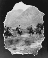
Film transparency of men on horses at Wilson's Ranch, Las Vegas, circa early 1900s
Date
1900 to 1910
Archival Collection
Description
Black and white image of four men on horses at Wilson's Ranch. Note: The image itself is ripped around its borders.
Image
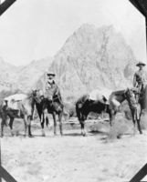
Film transparency of men with horses at Wilson's Ranch, Las Vegas, circa early 1900
Date
1900 to 1910
Archival Collection
Description
Black and white image of two men and four horses at Wilson's Ranch.
Image
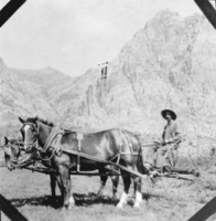
Film transparency of man with horses at Wilson's Ranch, Las Vegas, circa early 1900s
Date
1900 to 1910
Archival Collection
Description
Black and white image of a man sitting in a horse-drawn cart at Wilson's Ranch.
Image
Las Vegas High School girls during a physical education class: photographic print and photographic negative, approximately 1925 to 1929
Level of Description
Item
Archival Collection
K. O. Knudson Photograph Collection
To request this item in person:
Collection Number: PH-00108
Collection Name: K. O. Knudson Photograph Collection
Box/Folder: Folder 01, Box SH-021
Collection Name: K. O. Knudson Photograph Collection
Box/Folder: Folder 01, Box SH-021
Archival Component