Search the Special Collections and Archives Portal
Search Results
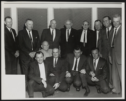
Photograph of Butch Leypoldt and other officers, (Nev.), approximately 1900-1950
Date
1900 to 1950
Archival Collection
Description
So. Nevada lawmen dressed in suits take a photo together at an unknown gathering. Butch Leypoldt is on the far left.
Image
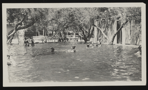
Photograph of people in swimming hole at Ladd's Resort, Las Vegas (Nev.), early 1900s
Date
Unknown year in the century of the 1900s
Archival Collection
Description
Unidentified people play in the swimming hole of Ladd's Resort in Las Vegas, NV. A rope is tied along the water between two trees that swimmers are holding on to. [Taken in the early 1900s]
Image
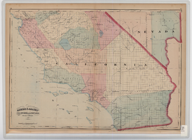
Map of southern California and southern Nevada, 1872
Date
1872
Description
'Entered according to Act of Congress in the year 1872 by Asher & Adams in the office of the Librarian of Congress at Washington.' Scale [ca. 1:1,267,300]. 1 in. to 20 miles (W 124°--W 114°/N 42°--N 32°). Shows natural features, populated places, county boundaries and railroads Prime meridians: Greenwich and Washington. In top margins: 95-96 (south portion). Shows range and township grid. Hand colored. Asher & Adams.
Image
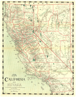
Map of California and Nevada, 1907
Date
1907
Description
Col. ; 57 x 43 cm., folded to 15 x 6 cm. Relief shown by hachures and spot heights. Published and copyrighted bu H.A. Candrian, 1907. "Mrs. H.A. Candrian, Dr'ng"--lower left corner.
Image
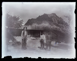
Photograph of the Wilsons at Standstone Ranch, Blue Diamond (Nev.), 1900
Date
1900
Archival Collection
Description
The Wilson's Sandstone Ranch (now within the boundaries of Spring Mountain Ranch State Park and Red Rock Canyon National Conservation Area). James B. Wilson Sr., the owner at left. His adopted sons Tweed (Anderson) Wilson, center and James Beck (Anderson) Wilson at right. Cabin in background with grapevine at left. Buster or Boone, son of Tweed, seated at left. 0105 0097 is a duplicate copy of this photo. Site Name: Spring Mountain Ranch (Blue Diamond, Nev.)
Image
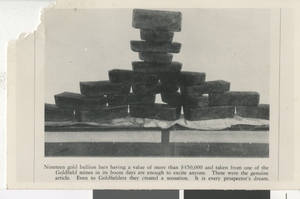
Photograph of gold bullion bars, Goldfield (Nev.), 1900-1920
Date
1900 to 1920
Archival Collection
Description
Nineteen gold bullion bars are stacked atop one another for a photo. Inscription below reads: "Nineteen gold bullion bars having a value of more than $450,000 and taken from one of the Goldfield mines in its boom days are enough to excite anyone. These were the genuine article. Even to Goldfielders they created a sensation. It is every prospector's dream."
Image
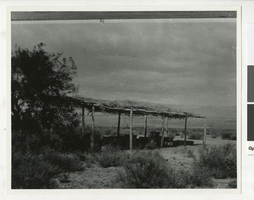
Photograph of Emery Homestead, Cottonwood Island (Nev.), 1900-1920
Date
1900 to 1920
Archival Collection
Description
Emery Homestead, located at Cottonwood Island. This photograph came with the description: "Emery Homestead. At Cottonwood Island Pop Emery raised bees and alfalfa while running the Arivada Ferry. These products were taken to Chloride, Arizona for sale. The farm was located at the upper end of Cottonwood Island on the Arizona side and was abandoned in 1920 when the ferry was moved to Tristate, a few miles above Bullshead Rock. Emery Collection."
Image
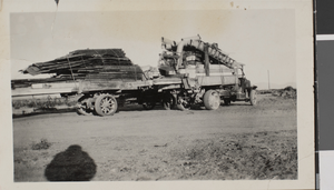
Postcard of a truck and trailer hauling equiptment, circa early to mid 1900s
Date
1910 to 1950
Archival Collection
Description
A truck and trailer hauling equipment, likely in Las Vegas or Searchlight, Nevada.
Image
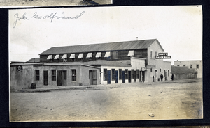
Photograph of a street scene near dance halls, Goldfield (Nev.), 1900-1920
Date
1900 to 1920
Archival Collection
Description
Caption: Jake Goodfriend
Site Name: Jake's Dance Hall (Goldfield, Nev.)
Pioneer Dance Hall (Goldfield, Nev.)
Site Name: Jake's Dance Hall (Goldfield, Nev.)
Pioneer Dance Hall (Goldfield, Nev.)
Image
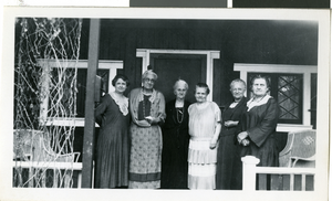
Photograph of a group of women, Las Vegas, circa early to mid 1900s
Date
1900 to 1959
Archival Collection
Description
A group of women, including Mrs. Mereness and Mrs. Brockman, at Alta Mereness Ham's home, located at 2nd & Carson, in Las Vegas, Nevada.
Image
Pagination
Refine my results
Content Type
Creator or Contributor
Subject
Archival Collection
Digital Project
Resource Type
Year
Material Type
Place
Language
Records Classification
