Search Results
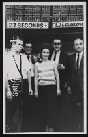
Diamond Jim's Nevada Club located in Las Vegas, Nevada: postcards
Date
1900 (year approximate) to 1999 (year approximate)
Archival Collection
Description
From the UNLV Libraries Single Item Accession Photograph Collection (PH-00171)
Image
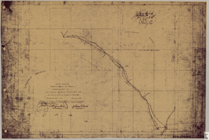
Map showing right of way of toll road constructed by Nevada Rapid Transit Co. in Lincoln County, State of Nevada
Date
1905-08-10
Description
Shows right of way of what now is Interstate 95 through what is now Clark County, Nevada. 'Aug. 10, 1905.' 'Adopted as toll road of Nevada Rapid Transit Company at meeting of Board of Directors of said company Aug. 25th, 1905. Attest W.H. Comstock, secretary, J. Ross Clark, president.' 'Book I, page 3'--Lower right corner. '... No. ... Recorded at ... [signed] J. Ross Clark ... September 1st A.D. 1905 at 40 ... past 8 A.M. to Book of Platts, Pages ... Lincoln Co. Nev. Record ... [signed] Henry Lee ...'--upper right portion of map. Seal of the Nevada Rapid Transit Company in lower left portion of map. Scale [ca. 126,720]. 1 in.=2 miles 1 map. Blueline print.
Image
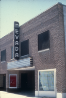
Slide of the Nevada Theater, Wells, Nevada, 1986
Date
1986
Archival Collection
Description
An image of the Nevada Theater located in Wells. The black and white neon sign located above the entrance doors to the building reads: "Nevada." Site Name: Nevada Theater (Wells, Nev.)
Image
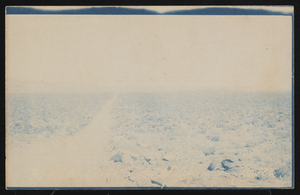
Road through the Nevada desert: postcard
Date
1900 (year approximate) to 1915 (year approximate)
Archival Collection
Description
Postcard of a dirt road through the Nevada desert.
Image
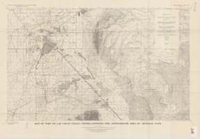
Map of part of Las Vegas Valley, Nevada, showing the approximate area of artesian flow, 1965
Date
1965
Description
At top of map: 'United States Department of the Interior, Geological Survey. Water supply paper 1780, plate 2.' At bottom of map: 'Base from U.S. Geological Survey Las Vegas (1952) and Henderson (1952) quadrangles.' 'Interior--Geological Survey, Washigton, D.C.--1965--W63358.' Relief shown by contours. Includes township and range lines. Thematic map. Scale 1:62,500 (W 115°15´--W 114°45´/N 36°15´--N 36°00´). Series: Water-supply paper (Washington, D.C.)
1780. Originally published as plate 2 of Available water supply of the Las Vegas ground-water basin, Nevada, by Glenn T. Malmberg, published by the Geological Survey in 1965 as its Water-supply paper 1780.
1780. Originally published as plate 2 of Available water supply of the Las Vegas ground-water basin, Nevada, by Glenn T. Malmberg, published by the Geological Survey in 1965 as its Water-supply paper 1780.
Image
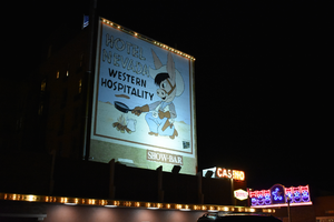
Hotel Nevada billboard, Ely, Nevada
Date
2016 (year approximate) to 2020 (year approximate)
Archival Collection
Description
View of the Hotel Nevada billboard reading "Hotel Nevada Western Hospitality."
501 E Aultman St, Ely, NV 89301
Image

Slide of Nevada Club, Ely, Nevada, 1986
Date
1986
Archival Collection
Description
An image of the exterior of the Nevada Club and Hotel Nevada in Ely. Mounted onto the brick building and hanging over the club's entrance is a large sign of a miner with a pickaxe. Various neon signs read: "Welcome, 21 Slots & Food, Dancing;" "Hotel Nevada;" "Free Parking;" and "Nevada Club."
Image
Lincoln Davis, Chicago; R. J. Shoemaker, Rochester, New York; and J. R. Hubbard a mining engineer, Nevada (identified from left to right). Mohawk Ledge Mining Company, Goldfield, Nevada. Inscription reads "I worked for Davis & Shoemaker in office and later at mine after panic hit. This was last work in Goldfield. Shoemaker formerly owned and operated a correspondence school at Rochester, New York": photographic print, approximately 1900-1915
Level of Description
Item
Archival Collection
C. A. Earle Rinker Photograph Collection of Goldfield, Nevada
To request this item in person:
Collection Number: PH-00350
Collection Name: C. A. Earle Rinker Photograph Collection of Goldfield, Nevada
Box/Folder: Oversized Box SH-066 (Restrictions apply)
Collection Name: C. A. Earle Rinker Photograph Collection of Goldfield, Nevada
Box/Folder: Oversized Box SH-066 (Restrictions apply)
Archival Component
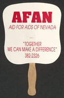
Aid for AIDS of Nevada fan
Date
1990 (year approximate) to 1999 (year approximate)
Archival Collection
Description
From the Dennis McBride Collection on LGBTQ Las Vegas, Nevada (MS-00802) -- Alphabetical research files -- AIDS: Organizations: Aid for AIDS of Nevada (AFAN) file.
Text
People in a Yosemite park area, "Selig moving picture outfit making 'The Rescue of Daniel Boone's Daughter'," (written on verso) Yosemite National Park, California: photographic print, approximately 1900 to 1909
Level of Description
Item
Archival Collection
Leon Rockwell Photograph Collection
To request this item in person:
Collection Number: PH-00008
Collection Name: Leon Rockwell Photograph Collection
Box/Folder: Folder 08
Collection Name: Leon Rockwell Photograph Collection
Box/Folder: Folder 08
Archival Component