Search Results
Borsanyi, Marta. The City: It's Future is Promising, It's Quality of Life in on the Rise, America West 1(11), approximately 1900 to 1999
Level of Description
Archival Collection
Collection Name: UNLV Libraries Collection of Articles on Gaming and Las Vegas, Nevada Topics
Box/Folder: Box 15
Archival Component
International Food Service Executives Association past presidents Frank Knapp, William R. Richter, Fred Klooz, and other unidentified men: photographic print, approximately 1925 to 1939
Level of Description
Archival Collection
Collection Name: International Food Service Executives Association Photograph Collection
Box/Folder: Oversized Box SH-068
Archival Component

Map of general plan for the Wells Siding Project in Logandale, Nevada, May 15, 1935
Date
Archival Collection
Description
Image

The Italian Benevolent Society and the Home for Aged Poor Fund, ball and supper, menu, Wednesday, March 7, 1900, The Monico, International Hall
Date
Archival Collection
Description
Text

Architectural drawings of a residential home in Las Vegas, Nevada, November 2, 1962
Date
Description
Exterior elevations and details for a residential home on Fifth Place in Las Vegas, Nevada. Sheet no. 4. "Drw. D.H."
Architecture Period: Mid-Century ModernistImage
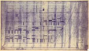
Plat of original townsite of Las Vegas, Clark County, Nevada, November 25, 1927
Date
Description
Subtitle: 'On N 1/2 of SW 1/4 section 27, T 20 S, R 61 E, M.D. Mer. showing cast iron water mains. Including location and distances of valves, fire hydrants, house connections, etc. Constructed by Las Vegas Land &Water Company. Construction completed Nov. 25-1927. Cast iron pipe system throughout made at Provo, Utah by Pacific States Cast Iron Pipe Company. R.N. Clark, Construction Engineer. Map and survey made by J.T. McWilliams, C.E., Las Vegas, Nev.' Map shows ownership of some parcels of land. Scale [ca. 1:960]. 1 inch to 80 feet. Blueline print. Plat map.
Image
The History of the Convict Hulk "Success" and "Success" Prisoners by Harvie, Joseph C. . Leeds: Petty & Sons, Ltd., 1900
Level of Description
Archival Collection
Collection Name: Mavis Eggle "Books as They Were Bought" Collection
Box/Folder: No Container 00
Archival Component
Electric Service Supplies Co.: Philadelphia-Chicago-New York Franklin Sales Co. catalog no. 5, 1900 to 1909
Level of Description
Archival Collection
Collection Name: Raymond Brooks Papers on Mining
Box/Folder: Box 05
Archival Component
Betty Trevor by de Horne Vaizey, Mrs. George. London: The Religious Tract Society, approximately 1900 to 1909
Level of Description
Archival Collection
Collection Name: Mavis Eggle "Books as They Were Bought" Collection
Box/Folder: No Container 00
Archival Component
Rubaiyat of Omar Khayyam: the astronomer poet of Persia by Edward Fitz Gerald. London: T. N. Foulis, approximately 1900 to 1909
Level of Description
Archival Collection
Collection Name: Mavis Eggle "Books as They Were Bought" Collection
Box/Folder: Box 30
Archival Component