Search Results
Butterfield, Roger. Harold's Club: Country's biggest gambling joint run by Smith family of Reno, Life 19(16), approximately 1900 to 1999
Level of Description
Archival Collection
Collection Name: UNLV Libraries Collection of Articles on Gaming and Las Vegas, Nevada Topics
Box/Folder: Box 10
Archival Component
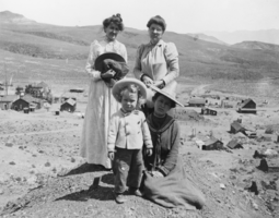
Irving Crowell as a child in Candelaria, Nevada: photographic print
Date
Archival Collection
Description
From the Nye County, Nevada Photograph Collection (PH-00221) -- Series III. Beatty, Nevada -- Subseries III.D. Crowell Family. The women in the photo are unidentified.
Image
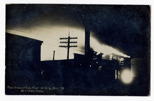
Fire in Goldfield, Nevada: postcard
Date
Archival Collection
Description
Image
University of Nevada, Las Vegas Photograph Collection
Identifier
Abstract
The University of Nevada, Las Vegas Photograph Collection (approximately 1900-2004) depicts the development of the university and the city of Las Vegas. The collection includes images of campus buildings, student activities, sports teams, past university presidents, and Las Vegas in the early twentieth century. Early images depicting the surrounding area are included in this collection as well.
Archival Collection
Southern Nevada Photo Album, image 007
Description
"Fishing trip near Moapa. Early Las Vegans: Ray Mosbach family, Jim Adams family, Leon Rockwell, Sr. family" (written on verso): photographic print, approximately 1915 to 1925
Level of Description
Archival Collection
Collection Name: Leon Rockwell Photograph Collection
Box/Folder: Folder 20
Archival Component

Topographic map of Cane Spring, Nevada quadrangle, 1961
Date
Description
Image

Map of California, Utah, Nevada, Colorado, New Mexico and Arizona, 1864
Date
Description
Text

Map of Las Vegas and vicinity, Nevada, circa 1957-1961
Date
Description
Image

Map of the Livingston Ranches near Overton, Clark County, Nevada, March 27, 1920
Date
Description
Image