Search Results

Film transparency of Olive Lake, Clyde McGriff, and Della McGriff, Las Vegas, circa early 1900s
Date
1900 to 1939
Archival Collection
Description
Black and white image of Olive Lake, Clyde McGriff, and Della McGriff at what appears to be a picnic, most likely located in Las Vegas. Handwritten on the bottom border of the image: "Olive, Clyde & Della McGriff." Note: Image is from a family photo album that was loaned to UNLV Libraries Special Collections and returned to the family on July 17, 1984.
Image

Map showing detailed topography of the country traversed by the reconnaissance expedition through southern & southeastern Nevada, 1869 (reproduction)
Date
1869
Description
At top of map: 'Reconnaissance Maps, Department of California.' 'In charge of, Lieut. Geo. M. Wheeler, U.S. Engineers; assisted by Lieut. D.W. Lockwood, Corps of Engineers,U.S.A., 1969.' 'P.W. Hamel, chief topographer and draugthsman.' 'Traced 11-13-67.' 'BGS'; the G is enclosed in an arrowhead shape. 'Officially compiled and published at the Engineer Office, Head Quarters Department of California in 1869 and 70 by order of Brigadier General E.O.C. Ord. Comm'dg. [signed] Geo. M. Wheeler, Lieutenant of Engineers In Charge, Head Quarters Dept. of Cal. Oct. 26th, 1870.' Includes information from railroad maps, the United States Geological Survey of the 40th parallel and from Lieutenant Ives' explorations along the Colorado. Map includes camps, astronomical stations, good and bad wagon roads, trails, springs, settlements, mining districts, state and county boundaries and the watershed between the Humboldt and Colorado Basin. Shows most of eastern half of Nevada. Relief shown by hachures and spot heights. Scale indeterminable. (W 117°00´--W 113°00´/N 41°45´--N 35°45´). Series: Reconnaissance maps. Military map / Department of California
no. 1. Reproduction. Map is printed in purple. Scale of original map: [1:760,320]. 1 in. to approx. 12 miles. Includes dots hand-colored with red pencil marking Indian rancherias.
no. 1. Reproduction. Map is printed in purple. Scale of original map: [1:760,320]. 1 in. to approx. 12 miles. Includes dots hand-colored with red pencil marking Indian rancherias.
Image
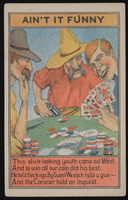
Postcard of gambling scene with two older men and a younger man winning the game, approximately 1900s-1980s
Date
1900 to 1989
Archival Collection
Description
A postcard illustrating a poker scene. The caption reads, "This slick-looking youth came out West, And to win all our coin did his best; He held five kings, by Gum! We each held a gun-And the Coroner held an inquest"
Image
Wind Mill Service Station, Las Vegas, Nevada, handwritten description included with the photograph, "first service station, Wind Mill Service Station": photographic print and negative, approximately 1900 to 1915
Level of Description
Item
Archival Collection
Leon Rockwell Photograph Collection
To request this item in person:
Collection Number: PH-00008
Collection Name: Leon Rockwell Photograph Collection
Box/Folder: Folder 01, Box SH-015
Collection Name: Leon Rockwell Photograph Collection
Box/Folder: Folder 01, Box SH-015
Archival Component
Album 5: photographs of community events and activities in Las Vegas, Nevada, including a WWI Liberty Bond parade, desert automobile rally, foot race, shooting competition, and horse race, 1900-1930s
Level of Description
File
Archival Collection
Maurine and Fred Wilson and Dr. William S. Park Photograph Albums
To request this item in person:
Collection Number: PH-00222
Collection Name: Maurine and Fred Wilson and Dr. William S. Park Photograph Albums
Box/Folder: Oversized Box 01
Collection Name: Maurine and Fred Wilson and Dr. William S. Park Photograph Albums
Box/Folder: Oversized Box 01
Archival Component
Standing outside car is Mary Maris Garside and her father Robert Maris, inside car are Sherwin Garside, Frank Garside and Virginia Garside, 1925
Level of Description
File
Archival Collection
Sherwin "Scoop" Garside Photographs
To request this item in person:
Collection Number: PH-00067
Collection Name: Sherwin "Scoop" Garside Photographs
Box/Folder: Folder 01
Collection Name: Sherwin "Scoop" Garside Photographs
Box/Folder: Folder 01
Archival Component

Film transparency of the Clark County High School basketball team, Las Vegas, circa early 1900s
Date
1910 to 1935
Archival Collection
Description
Black and white image of the basketball team for Clark County High School in Las Vegas.
Image
Young girl posed next to baby doll in stroller in front of a fence with desert landscape in the background on Christmas morning: photographic print, 1925 December 25
Level of Description
Item
Archival Collection
Hazel Baker Denton Photograph Collection
To request this item in person:
Collection Number: PH-00312
Collection Name: Hazel Baker Denton Photograph Collection
Box/Folder: Folder 02
Collection Name: Hazel Baker Denton Photograph Collection
Box/Folder: Folder 02
Archival Component
Virginia Beckley Richardson, Barbara (Ferron) Doyle, and Shirley (Ferron) Swanson at the Ferron home on the corner of 4th Street and Fremont Street, Las Vegas, Nevada (identified left to right on verso): photographic print and negative, approximately 1921 to 1925
Level of Description
Item
Archival Collection
Beckley Family Photograph Collection
To request this item in person:
Collection Number: PH-00148
Collection Name: Beckley Family Photograph Collection
Box/Folder: Folder 02, Box SH-023
Collection Name: Beckley Family Photograph Collection
Box/Folder: Folder 02, Box SH-023
Archival Component
Union Pacific Railroad: contains maps showing the physical city condition of Moapa, Nevada and locations in California such as Long Beach, Ontario, Los Angeles, Riverside, Fullerton, Clayton, Pomona, Wineville, and Hollydale, 1925 July 14-1929 February 21
Level of Description
File
Archival Collection
Union Pacific Railroad Collection
To request this item in person:
Collection Number: MS-00397
Collection Name: Union Pacific Railroad Collection
Box/Folder: Flat File 205
Collection Name: Union Pacific Railroad Collection
Box/Folder: Flat File 205
Archival Component