Search Results

Map of the Livingston Ranches near Overton, Clark County, Nevada, March 27, 1920
Date
Description
Image

Map of Las Vegas and vicinity, Nevada, circa 1957-1961
Date
Description
70 x 68 cm. on sheet 106 x 71 cm. Includes indexes. Includes Nellis Air Force Base, Henderson, and inset maps of Boulder City, Nevada, and Las Vegas's geographical location in the Southwest. "H-654-32" on the lower right-hand corner. Page 2 contains a photograph of the Fremont Street in Downtown Las Vegas, featuring the Golden Nugget Gambling Hall and the Horseshoe Casino. Page 3 outlines local and regional attractions, as well as population information. Original publisher: R. L. Polk.
Image
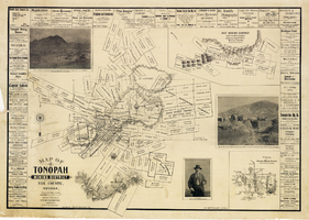
Map of Tonopah Mining District, Nye County, Nevada, 1902
Date
Description
Text

Map of California, Utah, Nevada, Colorado, New Mexico and Arizona, 1864
Date
Description
Text

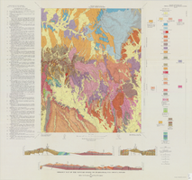
Geologic map of the Dead Horse Flat quadrangle, Nye County, Nevada, 1967
Date
Description
Image
Geologic map of the Topopah Spring NW quadrangle, Nye County, Nevada, 1965
Date
Description
Image

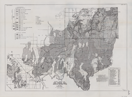
Geologic map of the Paiute Ridge quadrangle, Nye and Lincoln Counties, Nevada, 1967
Date
Description
58 x 46 cm., on sheet 85 x 83 cm., fold. in envelope 30 x 24 cm. Relief shown by contours and spot heights. "Contour interval 20 feet." "Prepared in cooperation with the U.S. Atomic Energy Commission." "Geology mapped in 1961. Contours on pre-Tertiary rocks by D. L. Healey and C. H. Miller, 1963." Includes text, 4 col. cross sections, and quadrangle location map. Original publisher: U. S. Geological Survey, Series: Geologic quadrangle map GQ, Scale: 1:24 000.
Image

Geologic map of the Jangle Ridge quadrangle, Nye and Lincoln Counties, Nevada, 1965
Date
Description
58 x 46 cm., on sheet 84 x 87 cm., folded in envelope 30 x 24 cm. Relief shown by contours and spot heights. "Contour interval 20 feet." "Prepared in cooperation with the U.S. Atomic Energy Commission." "Geology mapped in 1961. Limit of pluvial Groom Lake and faults from photographs mapped by R. B. Colton, 1962." Includes text, bibliography, location map, and 5 col. cross sections. Original publisher: Interior, U.S. Geological Survey, Series: Geologic quadrangle map GQ, Scale: 1:24 000.
Image

Plat showing original townsite and subdivisions, Las Vegas, Lincoln County, Nevada, May 1905
Date
Description
Land owned by the San Pedro, Los Angeles & Salt Lake Railroad is outlined. Scale: [ca. 1:12,000]. 1 inch = 1,000 feet. Cadastral map. Blueline print. Additional copy available in the J.T. McWilliams manuscript collection
Image
General geologic map of the Corners area, Arizona-Nevada-Utah, April 15, 1952
Date
Archival Collection
Description
Image