Search Results
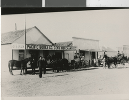
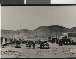
Photograph of Pacific Borax Company in Columbus (Nev.), 1880
Date
1880
Archival Collection
Description
Columbus, Esmeralda County, Nevada, about 1880. There is an inscription on the back of the image: "The Pacific Borax Company was one of four companies mining borax from nearby Columbus Salt Marsh at the time. The borax was discovered in 1872 by Francis M. "Borax" Smith. Columbus, which was settled in 1865, also supported four stamp mills which process the silver ore from the Columbus Mining District (Candelaria). The town's boom years were between 1873-1878 when the population was over 600. Nevada Historical Society Coll." There is a date stamp: Christmas 1984.
Image
Photograph of Berlin (Nev.), 1905
Date
1905
Archival Collection
Description
Berlin, Nevada 1905. There is an inscription on the back of the image: "Silver ore was discovered at the site in 1895. In 1898 the Nevada Company purchased the claims, developed the mine and installed a 30 stamp mill. Soon Berlin boasted a population of 250. There was a store, post office and a number of saloons in the area. Mining ceased by 1909 and the mill's machinery was removed in 1947. Today Berlin is a ghost town in a state of "arrested decay" and is part of the Berlin-Ichthyosaur Nevada Satate Park. Berlin's mines produced over $800,000. Don E. Lewis Collection." There is a date stamp: Christmas 1985.
Image
Photograph of Main Street in Palmetto (Nev.), 1906
Date
1906
Archival Collection
Description
Main Street, Palmetto, Esmeralda County, Nevada, 1906. There is an inscription on the back of the image: "Located 12 miles west of Lida, Nevada, Paletto was founded in 1866 after the discovery of silver in the area. The camp died and was reborn several times, the last of which was in 1906. Palmetto was named after the local joshua which its founders mistakenly thought was a relative of the palm tree. The district's mine eventually produced over $6,000,000. Nevada Historical Society Collection." There is a date stamp: mid-year 1986. Street Address: Main Street
Image
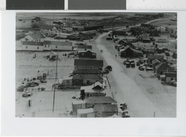
Photograph of Main Street in Silver Peak (Nev.), 1938
Date
1938
Archival Collection
Description
Main Street, Silver Peak, Nevada, 1938. There is an inscription on the back of the image: "In 1938, Silver Peak was Esmeralda County's largest and most prosperous town, boasting a population of over 1,000. The economy was supported chiefly by the nearby mines of the Nivloc and Mary Mine areas. The town's prosperity ended when the mines closed with the beginning of WWII." The section of town in the upper left corner of the photo, which included the post office, several stores and a theater was destroyed by fire in 1948. There is a date stamp: Christmas, 1986.
Image
Photograph of Gilbert (Nev.), 1925
Date
1925-02-25
Archival Collection
Description
Gilbert, Nevada, February 25, 1925. Gilbert was located in the Monte Cristo Range, 26 miles west of Tonopah. There is an inscription on the back of the image: "The town was founded as the result of a rich gold strike in the area by the Gilbert brothers in 1924. At its height (1925-1927), the town's population exceeded 400. After the boom, the mines maintained a small, steady production until World War II eventually forced them to close. In addition to gold, the district produced lead, silver and high grade turquoise. Nevada Historical Society Collection." There is a date stamp: 1987.
Image
Photograph of 1200 foot level, Belmont Mine in Tonopah (Nev.), 1911
Date
1911
Archival Collection
Description
1200 ft. level, Belmont Mine, Tonopah, NV, 1911. There is an inscription on the back of the image: "The Tonopah Belmont Development Company was Tonopah's second most prosperous mining company, recording a production of $38,000,000. The Belmont mine was the company's principal working shaft and reached a depth of 1700 feet. The Belmont shaft was in use from 1909 until it was burned out by a fire of undetermined origin October 31, 1939." There is a date stamp: mid-year 1987.
Image
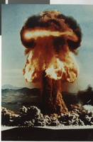
Photograph of atomic test Priscilla detonation, Nevada Test Site (Nev.), June 24, 1957
Date
1957-06-24
Archival Collection
Description
Atomic test "Priscilla" detonated at the Nevada Test Site in southern Nye County June 24, 1957. Priscilla was one of nearly one hundred atmospheric nuclear tests conducted at the site during the 1950s. Atmospheric testing was banned by treaty between the United States and the Soviet Union in 1963, although it had been moved underground in Nevada in 1959. Since 1951, more than 600 nuclear devices have been detonated at the Nevada Test Site.
Image
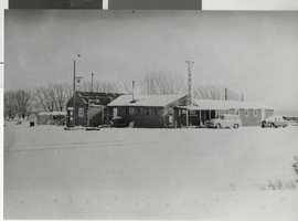
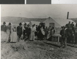
Photograph of Carver's Station, Smoky Valley, (Nev.), 1952
Date
1952
Archival Collection
Description
Carver's Station, Smoky Valley, Nevada, Main Street. (1906) There was an inscription on the image. "#51. Carver's Station, Smoky Valley, Nevada, 1952. The cafe and bar were opened in April, 1948 by Jean and Gerald Carver on Nevada route 8-A which had just been competed between Round Mountain and US 50 to the north. For many years, Carver's was an isolated stop on a lonely highway. Today, thanks to the nearby Round Mountain Gold mine, it has become a small community with a motel, bars, service stations, a small shopping center, trailer parks, church and other services."
Image
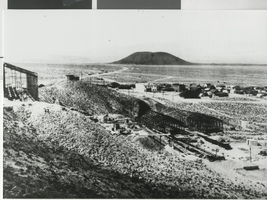
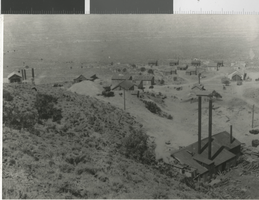
Panoramic photograph of Blair (Nev.), circa 1907
Date
1906 to 1908
Archival Collection
Description
There was an inscription on the image. "Blair was located three miles north of Silver Peak and was founded in 1906 by the Pittsburgh Silver Peak Gold Mining Company whose 120 stamp mill (under construction in the foreground) overlooked the town. Ore from the Mary Tunnel reached the mill via a 14,000 foot aerial tramway. The town's population was 700 and Blair was served by the mining company's Silver Peak Railroad. Blair prospered until 1917 when the mine and mill were closed. The mill processed over $6,000,000 worth of gold ore.
Image
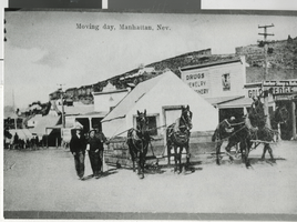
Photograph of a house moving, Manhattan (Nev.), circa 1906
Date
1905 to 1907
Archival Collection
Description
This was a tent house being moved from one location to another. There was an inscription on the image. "At the time the camp was in the process of establishing itself as a permanent town and as substantial frame buildings began replacing the tent houses, many were moved to new locations. Moving the structures was as simple as hooking up a few horses or recruiting a group of men to carry the smaller tents. Numerous tent houses, such as the one pictured here, became permanent homes when covered with boards and sheet metal. An example is the house in the Central Nevada Museum's 'town.'''
Image