
Search the Special Collections and Archives Portal

Search Results

Display    Results Per Page
Displaying results 101801 - 101810 of 103364

UNLV UndocuNetwork Student Group Records

Identifier

UA-00078

Abstract

The UNLV UndocuNetwork Student Group Records (2017) are comprised of postcards and fliers advertising events and workshops hosted by UNLV UndocuNetwork at the University of Nevada, Las Vegas in Las Vegas, Nevada. The records also include news stories and feature photography from the campus newspaper, UNLV Scarlet & Gray Free Press, about the student organization and their activities at UNLV.

Archival Collection

Thomas T. Beam Engineering Complex Photograph Collection

Identifier

UA-00113

Abstract

The Thomas T. Beam Engineering Complex Photographs (1988, 2006) mainly contains photographs and negatives of Building B of the Thomas T. Beam Engineering Complex construction in 2006. Photographs were taken by David Emerson who served positions within the University of Nevada, Las Vegas as Dean of the College of Science, Math, and Engineering; Dean of the College of Sciences; and as emeritus professor. Other materials in this collection include photographs of Lied Library and a photograph of Building A of the Thomas T. Beam Engineering Complex from 1988. The photograph includes a personal note to Emerson by Tate Snyder/Kittrell Garlock Architects, the architectural firm responsible for designing and building the Thomas T. Beam Engineering Complex.

Archival Collection

Map of California and Territories of New Mexico and Utah, 1862

Date

1862

Description

Scale [ca. 1:3,231,360. 1 in. to approx. 51 miles] (W 125°00--W 103°30/N 42°00--N 31°45) ; 1 map : hand col. ; 40 x 60 cm., on sheet 46 x 68 cm ; Relief indicated by hachures and spot heights ; Prime meridians: Greenwich and Washington, D.C ; Decorative border ; Hand colored ; Atlas p. numbers in upper margin: 58-59 ; Date est. from territorial borders and county configuration ; Shows natural features, locations of Indian tribes, proposed railroad routes, routes of explorers, trails, county boundaries and populated places ; Johnson and Ward

Image

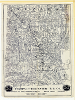
Map showing Tonopah & Tidewater Railroad Company line from Ludlow, California to Goldfield, Nevada, circa 1907

Date

1905 to 1909

Description

Scale not given. Relief shown by hachures and spot heights. Shows township and range grid. Shows mines, camps and ranches. Tonopah & Tidewater Railroad Company. Library's copy mounted on linen.

Image

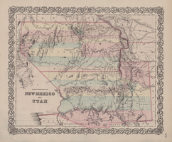
Map of territories of New Mexico and Utah, 1855

Date

1855

Description

29 x 36 cm. Shows natural features, and populated places, wagon route, proposed railroad routes and explorers' routes. Relief shown by hachures. Prime meridians: Greenwich and Washington. "Entered according to act of Congress in the year 1855 by J.H. Colton & Co in the Clerk's Office of the District Court of the U.S. for the Southern District of New York." Hand colored. Atlas p. number in lower-right margin: 51. Decorative border. The geographic region of Southwest is referred to as the New Southwest. Original publisher: J.H. Colton .

Image

Map of California, with territories of Utah, Nevada, Colorado, New Mexico, and Arizona, 1864

Date

1864

Description

40 x 62 cm. Relief shown by hachures. Prime meridians: Greenwich and Washington. Page numbers at top: 58-59. "Entered according to act of Congress in the year 1864 by A. J. Johnson in the Clerk's Office of the District Court of the United States for the Southern District of New York." Original publisher: Johnson and Ward.

Image

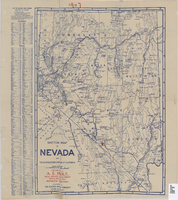
Sketch map of Nevada and the southeastern portion of California, 1906

Date

1906

Description

1907 written in red pencil at top of map. 41 x 29 cm. Relief shown by hachures. Copyright held by George S. Clason. Includes index. "Compliments of A.E. Holt, real estate and mines, Bullfrog Mining Dist., Rhyolite, Nevada." Red star indicates location of A.E. Holt company. Shows railroad routes. Library's copy has "1907" printed with brown crayon in upper margin and has four sets of two holes punched in a vertical line along the right third of the map. Original publisher: Clason Map Co..

Image