Search Results
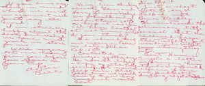
Scanned image of a handwritten note to Rex Bell (George Francis Beldam) by someone named Bill discussing business: personal papers
Date
Archival Collection
Description
Dorothy Bell Scans UNLV-Public Lands Institute
Text

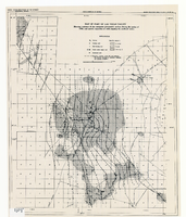
Topographic map of the northeast quadrangle of the metropolitan Las Vegas, Nevada area, 1967
Date
Description
Image

Plat of H.F.M & M addition to city of Las Vegas, Clark County, Nevada, comprising the west 1/2 of N.W. 1/4 Sec. 27, Twp. 20 S., R. 61 E., M.D.B & M, March 8, 1924
Date
Description
Image
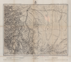
Map of part of central Colorado, May 7, 1877
Date
Description
38 x 48 cm. Relief shown by hachures and spot heights. "Atlas sheet no. 53(C)." "Issued May 7th 1877." "1st. Lieut. Geo. M. Wheeler, Corps of Engineers, U.S. Army." Prime meridians: Greenwich and Washington, D.C. Includes sectional diagram that shows how atlas sheets fit together. "Weyss, Herman & Lang, del." "Louis Nell, J. J. Young, topographical assistants." "Under the direction of Brig. General A. A. Hunphreys, Chief of Engineers, U. S. Army." "Expeditions of 1873 and 1876 under the command of 1st. Lieutenant William L. Marshall, Corps of Engineers, U. S. Army, 1st Lieutenant Eric Bergland, Corps of Engineers, U. S. Army, Executive Officers and field astronomers." "By order of the honorable the Secretary of War." Original publisher: Graphic Co. photo., Scale: 1 inch to 4 miles or 1:253440.
Image
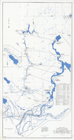
Map and operational diagram, lower Colorado River, Lees Ferry to Gulf of California, June 1973
Date
Description
Image
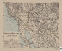
Map of Southwestern United States of America, 1888
Date
Description
Image
Map of part of Las Vegas Valley showing contours of the composite piezometric surface during the spring of 1944, and specific capacities of wells tapping the confined water
Date
Description
Relief shown by contours. Includes range and township grid. Shows springs and wells. Scale [ca. 1:67,162. 1 in. to approx. 1.06 miles]. Series: Water resources bulletin (Carson City, Nev.)
no. 5. Originally published as plate 8 in Geology and water resources of Las Vegas, Pahrump, and Indian Spring Valleys, Clark and Nye Counties, Nevada by George B. Maxey and C.H. Jameson, which is number 5 of the Water resources bulletin published by the Nevada Office of the State Engineer.
Image
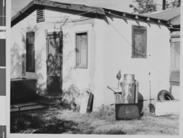
Photograph of a house in West Las Vegas, located adjacent to the North Project Boundary, Las Vegas, Nevada, October, 1957
Date
Archival Collection
Description
Image
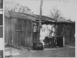
Photograph of a shack house in West Las Vegas, located at 711 Van Buren Avenue, Las Vegas, Nevada, October, 1957
Date
Archival Collection
Description
Image
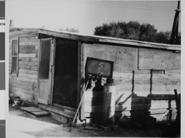
Photograph of a shack house in West Las Vegas, located at 1511 H Street, Las Vegas, Nevada, October, 1957
Date
Archival Collection
Description
Image