Search Results
#68269: UNLV Libraries holds a special 9/11 commemorative event unveiling of artist Troy Gillett's artwork made tee shirts left at the New York-New York Hotel Casino after the events of September 11, 2001 during a ceremony September 9, 2011 at the University of Nevada, Las Vegas Also in attendance was New York-New York President Cynthia Kiser Murphey., 2011 September 09
Level of Description
File
Archival Collection
University of Nevada, Las Vegas Creative Services Records (2010s)
To request this item in person:
Collection Number: PH-00388-05
Collection Name: University of Nevada, Las Vegas Creative Services Records (2010s)
Box/Folder: Digital File 00
Collection Name: University of Nevada, Las Vegas Creative Services Records (2010s)
Box/Folder: Digital File 00
Archival Component
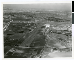
Aerial photograph of Hughes Airport, Culver City, California, circa 1940s-1950s
Date
1940 to 1959
Archival Collection
Description
Aerial view of Hughes Airport in Culver City, now Playa Vista, California. This private airport was owned by Howard Hughes and used for projects of the Hughes Aircraft Company and Hughes Tool Company. Lincoln Boulevard can be seen in the foreground, and on the left are Jefferson Boulevard and Ballona Creek.
Image

Map of California and territories of New Mexico and Utah, circa 1861
Date
1856 to 1866
Description
40 x 60 cm. Relief shown by hachures and spot heights. Prime meridians: Greenwich and Washington. Atlas plate numbers 54 and 55 in the upper corners. Shows forts, trails, exploration routes, drainage, mail steamship routes, physical features, Indian tribes, and historic sites. The geographic region of Southwest is referred to as the New Southwest. Original publisher: Johnson .
Image
Lockheed 14 aircraft, Floyd Bennett Field, New York, 1938 July 10
Level of Description
File
Archival Collection
Howard Hughes Public Relations Photograph Collection
To request this item in person:
Collection Number: PH-00373
Collection Name: Howard Hughes Public Relations Photograph Collection
Box/Folder: Folder 06
Collection Name: Howard Hughes Public Relations Photograph Collection
Box/Folder: Folder 06
Archival Component
DirecTV "Hughes Interview B-Roll" with New Logo, 2001 May 07
Level of Description
File
Archival Collection
Hughes Electronics Corporation Records
To request this item in person:
Collection Number: MS-00485
Collection Name: Hughes Electronics Corporation Records
Box/Folder: Box 14
Collection Name: Hughes Electronics Corporation Records
Box/Folder: Box 14
Archival Component
T-Shirt Color: Black; Front: Hell's Gate City Of New York Police 114th Pct. Astoria NY, Dept. Badge, approximately 2001-2012
Level of Description
File
Archival Collection
New York-New York Hotel and Casino 9-11 Heroes Tribute Collection
To request this item in person:
Collection Number: MS-00459
Collection Name: New York-New York Hotel and Casino 9-11 Heroes Tribute Collection
Box/Folder: Box 259
Collection Name: New York-New York Hotel and Casino 9-11 Heroes Tribute Collection
Box/Folder: Box 259
Archival Component
T-Shirt Color: Gray; Front: FDNY Fire Department City Of New York, Dept. Emblem; Handwritten Text: We Will Not Forget - The Campbells, approximately 2001-2012
Level of Description
File
Archival Collection
New York-New York Hotel and Casino 9-11 Heroes Tribute Collection
To request this item in person:
Collection Number: MS-00459
Collection Name: New York-New York Hotel and Casino 9-11 Heroes Tribute Collection
Box/Folder: Box 116
Collection Name: New York-New York Hotel and Casino 9-11 Heroes Tribute Collection
Box/Folder: Box 116
Archival Component