Search Results

Map of California, Utah, Nevada, Colorado, New Mexico and Arizona, 1864
Date
1864
Description
'Johnson's California, also Utah, Nevada, Colorado, New Mexico, and Arizona, published by A.J. Johnson, New York.' 'Entered according to Act of Congress in the Year 1864, by A.J. Johnson in the Clerks Office of the District Court of the United States for the Southern District of New York.' Atlas page numbers in upper margin: 66-67. Relief shown by hachures. Prime meridians: Greenwich and Washington, D.C. Shows proposed railroads, locations of Indian tribes, natural features, counties, mines, mail routes, trails and routes of exploring expeditions. On verso: History and statistics of Mexico and Central America and statistics of national finances and the Post Office of the United States, 1860. Scale [ca. 1:3,484,800. 1 in. to ca. 55 miles] (W 123°--W 103°/N 42°--N 32°)
Text
"Howard Hughes the Aviator" Sub-Master with Code, 1986 April 15
Level of Description
File
Archival Collection
Hughes Electronics Corporation Records
To request this item in person:
Collection Number: MS-00485
Collection Name: Hughes Electronics Corporation Records
Box/Folder: Box 12
Collection Name: Hughes Electronics Corporation Records
Box/Folder: Box 12
Archival Component
Henderson City Hall. Contains memos, list and appeals, 1975 March
Level of Description
File
Archival Collection
Howard Cannon Papers
To request this item in person:
Collection Number: MS-00002
Collection Name: Howard Cannon Papers
Box/Folder: Box 05 (Las Vegas files)
Collection Name: Howard Cannon Papers
Box/Folder: Box 05 (Las Vegas files)
Archival Component
Ribbon cutting ceremony for North Las Vegas City Hall, 1966
Level of Description
File
Archival Collection
North Las Vegas Library Photograph Collection on North Las Vegas, Nevada
To request this item in person:
Collection Number: PH-00277
Collection Name: North Las Vegas Library Photograph Collection on North Las Vegas, Nevada
Box/Folder: Folder 05
Collection Name: North Las Vegas Library Photograph Collection on North Las Vegas, Nevada
Box/Folder: Folder 05
Archival Component
North Las Vegas City Hall dedication ceremony, 1966 December
Level of Description
File
Archival Collection
North Las Vegas Library Photograph Collection on North Las Vegas, Nevada
To request this item in person:
Collection Number: PH-00277
Collection Name: North Las Vegas Library Photograph Collection on North Las Vegas, Nevada
Box/Folder: Folder 05
Collection Name: North Las Vegas Library Photograph Collection on North Las Vegas, Nevada
Box/Folder: Folder 05
Archival Component
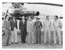
Photograph of Howard Hughes with XH-17 helicopter, Culver City, California, October 23, 1952
Date
1952-10-23
Archival Collection
Description
L-R: Rea Hopper, Director of the Aeronautical Division, Hughes Aircraft Company; Howard Hughes; Clyde Jones, Director of Engineering, Hughes Tool Company Aeronautical Division; Warren Reed, Assistant; Col. Carl E. Jackson, Air Research and Development Headquarters, Baltimore; Gale J. Moore, pilot; and unidentified pilot in front of the experimental helicopter XH-17 Flying Crane on October 23, 1952. This was one of Hughes' last public appearances.
Image
Howard Hughes boarding airliner for Washington, D.C., 1938 July 15
Level of Description
File
Archival Collection
Howard Hughes Public Relations Photograph Collection
To request this item in person:
Collection Number: PH-00373
Collection Name: Howard Hughes Public Relations Photograph Collection
Box/Folder: Folder 13
Collection Name: Howard Hughes Public Relations Photograph Collection
Box/Folder: Folder 13
Archival Component
Exterior of North Las Vegas City Hall, approximately 1966-1969
Level of Description
File
Archival Collection
North Las Vegas Library Photograph Collection on North Las Vegas, Nevada
To request this item in person:
Collection Number: PH-00277
Collection Name: North Las Vegas Library Photograph Collection on North Las Vegas, Nevada
Box/Folder: Folder 05
Collection Name: North Las Vegas Library Photograph Collection on North Las Vegas, Nevada
Box/Folder: Folder 05
Archival Component
North Las Vegas City Hall and Library, 1968 March 25
Level of Description
File
Archival Collection
Frank Mitrani Photographs
To request this item in person:
Collection Number: PH-00332
Collection Name: Frank Mitrani Photographs
Box/Folder: Box 44
Collection Name: Frank Mitrani Photographs
Box/Folder: Box 44
Archival Component
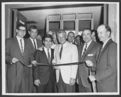
Photograph of the ribbon cutting ceremony for North Las Vegas City Hall, circa 1966
Date
1905-05-19
Archival Collection
Description
From left to right: a picture of John Walsh, Joe Cunningham, Dante Vespignani, Milt Wiers, John Fadgen, Mayor William Taylor (light jacket), Councilman Jack Petitti (second from right), Pete Green, Joe Mindyas, and James Johnson at a ribbon cutting ceremony in North Las Vegas City Hall.
Image