Search the Special Collections and Archives Portal
Search Results
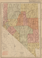
Rand-McNally new commercial atlas map of Nevada, 1912
Date
1912
Description
Original publisher: Rand, McNally & Co. Scale [ca. 1:1,203,840). 1 inch to 19 miles. Originally published as p. 316-317 of Rand McNally's commercial atlas of America. Title in right margin: Nevada : commercial atlas of America. Includes township and range grid. Includes index to Nevada railroads and index to principal cities with their populations. Index on verso to counties, towns and natural features in Oregon and Nevada.
Image
City Swiss Club, annual banquet, menu, at The Monico International Hall, 1902 December 12
Level of Description
Item
Archival Collection
Bohn-Bettoni Menu Collection
To request this item in person:
Collection Number: MS-00793
Collection Name: Bohn-Bettoni Menu Collection
Box/Folder: Box 07
Collection Name: Bohn-Bettoni Menu Collection
Box/Folder: Box 07
Archival Component
Resorts International Hotel: Atlantic City, New Jersey, 1982-07-22
Level of Description
Series
Archival Collection
Martin Stern Architectural Records
To request this item in person:
Collection Number: MS-00382
Collection Name: Martin Stern Architectural Records
Box/Folder: N/A
Collection Name: Martin Stern Architectural Records
Box/Folder: N/A
Archival Component
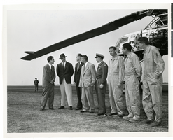
Photograph of Howard Hughes with a group of men in front of the XH-17 helicopter, Culver City, California, October 23, 1952
Date
1952
Archival Collection
Description
Howard Hughes (second from left) standing in front of the experimental helicopter XH-17, Flying Crane, with others (from left to right): Rea Hopper, Director of the Aeronautical Division, Hughes Aircraft Company; Hughes; Clyde Jones, Director of Engineering, Hughes Tool Company Aeronautical Division; Warren Reed, Assistant; Colonel Carl E. Jackson, Air Research and Development Headquarters, Baltimore; Gale J. Moore, Pilot; possibly Chal Bowen, Flight Engineer/Co-pilot, and an unidentified man, October 23, 1952.
Image
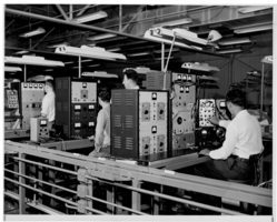
Photograph of electronic equipment testing at Hughes Aircraft Company, Culver City, California, 1959
Date
1959
Archival Collection
Description
Technicians working with large pieces of electronic equipment.
Image
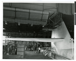
Photograph of the interior of an airplane hangar at the Hughes Helicopters Division of Summa Corporation, Culver City, California, circa late 1950s
Date
1957 to 1959
Archival Collection
Description
A view of the inside of an airplane hangar at the Hughes Helicopters Division of Summa Corporation in Culver City, California in the late 1950s.
Image
North Las Vegas Libriary under construction and City Hall, Civic Center Drive, 1965
Level of Description
File
Archival Collection
North Las Vegas Library Photograph Collection on North Las Vegas, Nevada
To request this item in person:
Collection Number: PH-00277
Collection Name: North Las Vegas Library Photograph Collection on North Las Vegas, Nevada
Box/Folder: Folder 04
Collection Name: North Las Vegas Library Photograph Collection on North Las Vegas, Nevada
Box/Folder: Folder 04
Archival Component
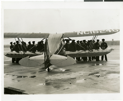
Photograph of police in readiness for arrival of Howard Hughes' plane at Floyd Bennett Airport, New York, July 14, 1938
Date
1938-07-14
Archival Collection
Description
The black and white view of police men awaiting the arrival of the Lockheed 14 aircraft at Floyd Bennett Airport in New York. Typed onto a piece of paper attached onto the image: "Police in readiness for arrival of Hughes' plane, Floyd Bennett Airport, N.Y. -- Police lined up in front of a plane at Floyd Bennett Airport, as last-minute preparations were made for the arrival of Howard Hughes and his companions, who were winging over North Central America on the last leg of their epochal Round-The-World flight. By noon a crowd of 6,000 persons had assembled and countless others choked all roads leading to the field as the fliers drew nearer to their goal. Credit Line (ACME) 7/14/38."
Image
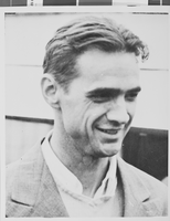
Photograph of Howard Hughes, July 7, 1939
Date
1939-07-07
Archival Collection
Description
Description given with photograph: "Howard Hughes pleased with new Stratoliner."
Image
Judith Blackburn and Lou McGraw regarding files Howard Hall transferred to the Hughes Productions Hollywood office, 1957 April 15
Level of Description
File
Archival Collection
Howard Hughes Film Production Records
To request this item in person:
Collection Number: MS-01036
Collection Name: Howard Hughes Film Production Records
Box/Folder: Box 155 (Restrictions apply)
Collection Name: Howard Hughes Film Production Records
Box/Folder: Box 155 (Restrictions apply)
Archival Component
Pagination
Refine my results
Content Type
Creator or Contributor
Subject
Archival Collection
Digital Project
Resource Type
Year
Material Type
Place
Language
Records Classification
