Search the Special Collections and Archives Portal
Search Results
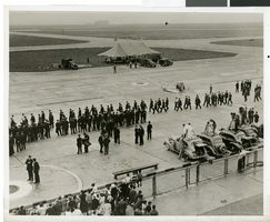
Photograph Howard Hughes arrival at Floyd Bennett Airport, New York, July 14, 2013
Date
1938-07-14
Archival Collection
Description
The black and white view of a crowd of people awaiting the arrival of Howard Hughes at Floyd Bennett Airport in New York. Typed onto a piece of paper attached to the image: "Just before world fliers landed, Floyd Bennett Airport, N.Y. -- A small army of policemen pictured on the runway here shortly before Howard Hughes and his four companions landed, ending their Round-The-World flight. Note newsreel photographers on the right. In the background is the tent from which Hughes and his fellow fliers spoke to a vast radio audience. Credit line (ACME) 7(3/4)/14/38."
Image
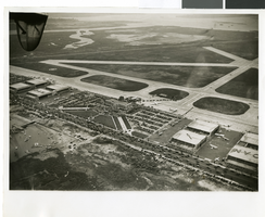
Photograph of the landing of Howard Hughes' Lockheed 14 aircraft, New York, July 14, 1938
Date
1938-07-14
Archival Collection
Description
The black and white, aerial view of Howard Hughes' Lockheed 14 aircraft performing its final landing on the Round the World flight at Floyd Bennett Airport, New York. Typed onto a piece of paper attached to the image: "Journey's End: This airplane view records the end of Howard Hughes' history-making dash around the world in three days, nineteen hours. To the right of the Administration Building at Floyd Bennett Field, Long Island, New York, can be seen the globe-girdling monoplane surrounded by a ring of policemen. The foreground provides an accurate idea of the size of the crowd which stormed the field to welcome home the fliers. Credit Line (ACME)."
Image
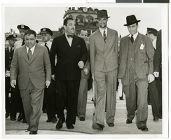
Photograph of Howard Hughes and Grover Whalen at Floyd Bennett Airfield, New York, July 14, 1938
Date
1938-07-14
Archival Collection
Description
A view of Howard Hughes and Grover Whalen leaving Floyd Bennett Airfield.
Image
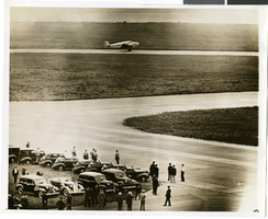
Photograph of the landing of Howard Hughes' Lockheed 14 aircraft, New York, July 14, 1938
Date
1938-07-14
Archival Collection
Description
The black and white, aerial view of Howard Hughes' Lockheed 14 aircraft performing its final landing on the Round the World flight at Floyd Bennett Airport, New York. Typed onto a piece of paper attached to the image: "Howard Hughes big silver monoplane landing at Floyd Bennett Field his afternoon completing a record flight around the world in 3 days, 13 hours, and 17 minutes. 7/14/38 (Press Association)."
Image
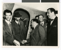
Photograph of Howard Hughes with Fiorello La Guardia and Grover Whalen, New York, July 12, 1938
Date
1938-07-12
Archival Collection
Description
Howard Hughes (wearing hat) receives congratulations from Mayor Fiorello La Guardia at Floyd Bennett Airport in Brooklyn. The gentleman wearing a polka dot bow tie, standing behind the mayor is Grover Whalen. Mr. Whalen was president of the 1939 New York World's Fair.
Image
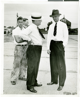
Photograph of Howard Hughes and W.D. "Jim" Guthrive at Roosevent Field, New York, July 18, 1938
Date
1938-07-18
Archival Collection
Description
Handwritten on the back of the image: "Talking to W.D. "Jim" Guthrive at Roosevelt Field. 7/18/38."
Image
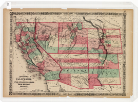
Map of California, Utah, Nevada, Colorado, New Mexico and Arizona, 1864
Date
1864
Description
'Johnson's California, with Utah, Nevada, Colorado, New Mexico, and Arizona, published by Johnson and Ward.' 'Entered according to Act of Congress in the Year 1864 by A.J. Johnson in the Clerks Office of the District Court of the United States for the southern district of New York.' Atlas page numbers in upper margin: 66-67. This is probably plate 67 from Johnson's New Illustrated Family Atlas, published in New York by Johnson & Ward in 1864. Shows natural features, locations of Indian tribes, proposed railroad routes, routes of explorers, trails, county boundaries and populated places ; "." ; Relief shown by hachures ; Prime meridians: Greenwich and Washington ; In top margin: 66-67 ; Hand colored ; On verso: Historical and statistical view of Mexico and central America (p. 79) and Historical and statistical view of the United States, 1860 (p. 78) Scale [ca. 1:3,484,800]. 1 in. to ca. 55 miles (W 124°--W 102°/N 42°--N 32°)
Text

Photograph of Howard Hughes' plane at Floyd Bennet Airfield, New York, August 20, 1938
Date
1938-08-20
Archival Collection
Description
Description given with photograph: "Hughes sets new transcontinental transport mark. Floyd Bennet Field, NY--- Howard Hughes, millionaire flier, setting his famous round-the-world transport plane down here, early August 20th, after a record-smashing flight from Los Angeles. Hughes and three companions completed the trip in 10 hours 32 minutes and 20 seconds, shattering the record of 11 hours and five minutes set four years ago by Tommy Tomlinson. The flight was made most of the way in the substratosphere at an average altitude of 17, 000 feet. Credit Line ACME."
Image
Ashley Hall oral history interview
Identifier
OH-02488
Abstract
Oral history interview with Ashley Hall conducted by Claytee D. White on September 2, 2015 and September 22, 2015 for the Building Las Vegas Oral History Project. Hall discusses being the city manager of Las Vegas, Nevada during the early portion of the development of Summerlin, Nevada by the Hughes Corporation. He also discusses his earlier life before politics, pertaining to Nevada Trench Safety.
Archival Collection
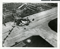
Photograph of the landing of Howard Hughes' Lockheed 14 aircraft, New York, July 14, 1938
Date
1938-07-14
Archival Collection
Description
The black and white, aerial view of Howard Hughes' Lockheed 14 aircraft after performing its final landing on the Round the World flight at Floyd Bennett Airport, New York. Typed onto a piece of paper attached to the image: "Crowds welcome round the world flyers at Floyd Bennett Field 7/14/38. (Press Association)"
Image
Pagination
Refine my results
Content Type
Creator or Contributor
Subject
Archival Collection
Digital Project
Resource Type
Year
Material Type
Place
Language
Records Classification
