Search Results
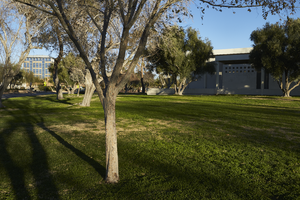
Landscaping in front of the former North Las Vegas City Hall building with new City Hall building in background in North Las Vegas, Nevada: digital photograph
Date
2019-02-06
Archival Collection
Description
From the UNLV University Libraries Photographs of the Development of the Las Vegas Valley, Nevada (PH-00394). Part of the collection documents the entire 19 mile length of the north/south Eastern Avenue / Civic Center Drive alignment. This photograph was captured in the section of Civic Center Drive between Las Vegas Boulevard and Lake Mead Boulevard.
Image
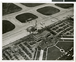
Photograph of the landing of Howard Hughes' Lockheed 14 aircraft, New York, July 14, 1938
Date
1938-07-14
Archival Collection
Description
The black and white, aerial view of Howard Hughes' Lockheed 14 aircraft performing its final landing on the Round the World flight at Floyd Bennett Airport, New York. Typed onto a piece of paper attached to the image: "Journey's End for World Fliers! Floyd Bennett Airport, N. Y. ---- The "World's Fair 1939.," Howard Hughes' silver monoplane, shown on the ground just after it landed here, concluding an amazing globe-girdling flight in total elapsed time of 3 days, 19 hours, 10 seconds. A crowd of officials surround the plane. Credit Line (ACME) 7/14/38."
Image
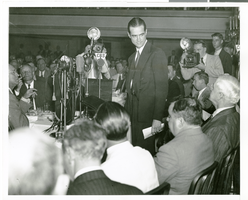
Photograph of Howard Hughes speaking at the National Press Club, New York City, July 15, 1938
Date
1938-07-15
Archival Collection
Description
Typed onto a piece of paper attached to the image: "Howard Hughes and his four companions honored at the National Press Club. Howard Hughes is speaking, with Mayor La Guardia and Secretary of State Cordell Hull at lower right. July 1938."
Image
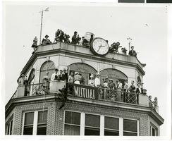
Photograph of people atop a tower awaiting the arrival of Howard Hughes, New York, July 14, 1938
Date
1938-07-14
Archival Collection
Description
The black and white view of a crowd of people, possibly including reporters and members of the press, standing atop a tower as they wait for the arrival of Howard Hughes in his Lockheed 14 aircraft at Floyd Bennett Airport, New York. This final landing for Hughes marked the end of his Round The World flight.
Image
Photograph of a crowd of people awaiting the arrival of Howard Hughes, New York, July 14, 1938
Date
1938-07-14
Archival Collection
Description
The black and white view of members of the Aeronautical Association awaiting the arrival of Howard Hughes and his Lockheed 12 aircraft at the Floyd Bennett Airport in New York. Typed onto a piece of paper attached to the image: "Official timers of Aeronautical Association compare their precision chronometers as Lockheed-14 roars overhead, marking end of Round-the-World flight at Floyd Bennett Airport." Typed onto a second piece of paper also attached to the image: "Official timers of the Aeronautical Association shown at Floyd Bennett Field comparing their precision chronometers as Howard Hughes' plane roared overhead marking the end of his Flight Around The World. July 1938."
Image
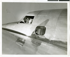
Photograph of Howard Hughes in his Lockheed 14 aircraft, Floyd Bennett Field, New York, July 10, 1938
Date
1938-07-10
Archival Collection
Description
The black and white view of Howard Hughes in his Lockheed 14 aircraft at Floyd Bennett Field in New York. Text printed on accompanying paper strip: "Hughes takes off on flight to Paris. Floyd Bennett Field, New York City-- Howard Hughes, multi-millionaire speed flyer, pictured in the nose of his Hughes Lockheed "Flying Laboratory" as Hughes and his picked crew of four prepared for the take-off to Paris and probably around the world on July 10th. A few minutes after this picture was taken, the giant ship lifted from the field to follow the trail blazed by Chrales A. Lindbergh. Credit Line (ACME) 7/10/38."
Image
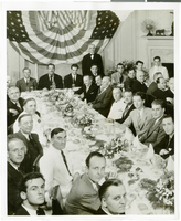
Photograph of a luncheon for the completion of Howard Hughes' Round the World flight, New York City, July 15, 1938
Date
1938-07-15
Archival Collection
Description
Typed onto a piece of paper attached to the image: "Fete, Hughes, and crew at Luncheon. Left to right at the head of the table are Harry P. Connor, navigator of the Hughes plane, Grover Whalen, Howard hughes, Mayor Fiorello Laguardia of New York City, Thomas Thurlow, Navigator, Richard Stoddart, radio engineer, and Edward Lund, flight engineer. At the bottom center of the photo is William Randolph Hearst, Jr., son of the publisher. 7/15/38"
Image

Map of California, with territories of Utah, Nevada, Colorado, New Mexico, and Arizona, 1864
Date
1864
Description
40 x 62 cm. Relief shown by hachures. Prime meridians: Greenwich and Washington. Page numbers at top: 58-59. "Entered according to act of Congress in the year 1864 by A. J. Johnson in the Clerk's Office of the District Court of the United States for the Southern District of New York." Original publisher: Johnson and Ward.
Image
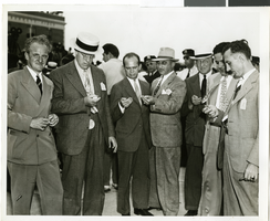
Howard Hughes and party being welcomed at City Hall, greeted by Jesse Jones, 1938 July 15
Level of Description
File
Archival Collection
Howard Hughes Public Relations Photograph Collection
To request this item in person:
Collection Number: PH-00373
Collection Name: Howard Hughes Public Relations Photograph Collection
Box/Folder: Folder 12
Collection Name: Howard Hughes Public Relations Photograph Collection
Box/Folder: Folder 12
Archival Component

Map of California, Utah, Nevada, Colorado, New Mexico and Arizona, 1864
Date
1864
Description
'Johnson's California, with Utah, Nevada, Colorado, New Mexico, and Arizona, published by Johnson and Ward.' 'Entered according to Act of Congress in the Year 1864 by A.J. Johnson in the Clerks Office of the District Court of the United States for the southern district of New York.' Atlas page numbers in upper margin: 66-67. This is probably plate 67 from Johnson's New Illustrated Family Atlas, published in New York by Johnson & Ward in 1864. Shows natural features, locations of Indian tribes, proposed railroad routes, routes of explorers, trails, county boundaries and populated places ; "." ; Relief shown by hachures ; Prime meridians: Greenwich and Washington ; In top margin: 66-67 ; Hand colored ; On verso: Historical and statistical view of Mexico and central America (p. 79) and Historical and statistical view of the United States, 1860 (p. 78) Scale [ca. 1:3,484,800]. 1 in. to ca. 55 miles (W 124°--W 102°/N 42°--N 32°)
Text