Search Results
Harrah's Grand, Atlantic City, New Jersey, 2001
Level of Description
File
Archival Collection
Robert Beckmann Photographs
To request this item in person:
Collection Number: PH-00381
Collection Name: Robert Beckmann Photographs
Box/Folder: Box 02
Collection Name: Robert Beckmann Photographs
Box/Folder: Box 02
Archival Component
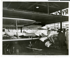
Photograph of the Hughes Racer, circa 1937
Date
1936 to 1938
Archival Collection
Description
The black and white view of the Hughes Racer in a hangar.
Image

City map of Las Vegas, 1973
Date
1905-05-26
Description
Color; 55 x 45 cm., on sheet 95 x 47 cm., folded to 24 x 10 cm. Panel title: Las Vegas city map. Copyright held by Cardinal Publishing Company. Relief shown by hachures. Includes illustrations and advertisements. Index, text, illustrations, advertisements, and map of "Lake Mead National Recreation Area, lower basin section" on verso. Original publisher: Cardinal Publishing Company.
Image
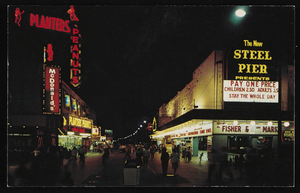
Nighttime view of Atlantic City, New Jersey: postcard
Date
1940 (year approximate) to 1990 (year approximate)
Archival Collection
Description
From Harvey's Hotel and Casino Postcard Collection (PH-00367)
Image

Map of California and Territories of New Mexico and Utah, 1862
Date
1862
Description
Scale [ca. 1:3,231,360. 1 in. to approx. 51 miles] (W 125°00--W 103°30/N 42°00--N 31°45) ; 1 map : hand col. ; 40 x 60 cm., on sheet 46 x 68 cm ; Relief indicated by hachures and spot heights ; Prime meridians: Greenwich and Washington, D.C ; Decorative border ; Hand colored ; Atlas p. numbers in upper margin: 58-59 ; Date est. from territorial borders and county configuration ; Shows natural features, locations of Indian tribes, proposed railroad routes, routes of explorers, trails, county boundaries and populated places ; Johnson and Ward
Image
Latin Quarter (New York): contract (typescript) between Donn Arden and E.M. Loew
Date
1957-07
Archival Collection
Description
Series 2: Nightclubs
Text
The German Society of New York, 150th Anniversary Banquet, menu, 1934 November 22
Level of Description
File
Archival Collection
UNLV University Libraries Menu Collection
To request this item in person:
Collection Number: MS-00436
Collection Name: UNLV University Libraries Menu Collection
Box/Folder: Box 118
Collection Name: UNLV University Libraries Menu Collection
Box/Folder: Box 118
Archival Component
Willig, John. Off-track betting, from the horse's mouth: voting by New Yorkers, New York Times, 1963 November 03
Level of Description
File
Archival Collection
UNLV Libraries Collection of Articles on Gaming and Las Vegas, Nevada Topics
To request this item in person:
Collection Number: MS-00626
Collection Name: UNLV Libraries Collection of Articles on Gaming and Las Vegas, Nevada Topics
Box/Folder: Box 10
Collection Name: UNLV Libraries Collection of Articles on Gaming and Las Vegas, Nevada Topics
Box/Folder: Box 10
Archival Component
Las Vegas Shooting Victims: The Full List - The New York Times: archived website, 2017
Level of Description
Other Level
Archival Collection
Web Archive on the October 1, 2017 Shooting in Las Vegas, Nevada
To request this item in person:
Collection Number: MS-00866
Collection Name: Web Archive on the October 1, 2017 Shooting in Las Vegas, Nevada
Box/Folder: N/A
Collection Name: Web Archive on the October 1, 2017 Shooting in Las Vegas, Nevada
Box/Folder: N/A
Archival Component
In Las Vegas, We Take Care of People - The New York Times: archived website, 2017
Level of Description
Other Level
Archival Collection
Web Archive on the October 1, 2017 Shooting in Las Vegas, Nevada
To request this item in person:
Collection Number: MS-00866
Collection Name: Web Archive on the October 1, 2017 Shooting in Las Vegas, Nevada
Box/Folder: N/A
Collection Name: Web Archive on the October 1, 2017 Shooting in Las Vegas, Nevada
Box/Folder: N/A
Archival Component