Search Results
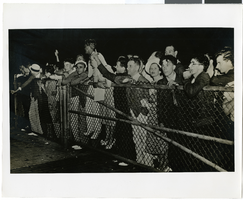
Photograph of a crowd greeting Howard Hughes at Floyd Bennett Field Airport, July 14, 1938
Date
Archival Collection
Description
Image
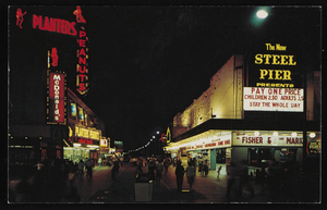
Nighttime view of Atlantic City, New Jersey: postcard
Date
Archival Collection
Description
Image
Hughes Electronics Corporation Records
Identifier
Abstract
The Hughes Electronics Corporation Records (1935-2021) contain the files and publications of the corporate communications department and records donated by Robert K. Roney, a leading engineer at Hughes. These records document the growth of the company in Southern California, from building experimental aircraft for Howard Hughes, to developing and manufacturing radar and guided missile systems for the United States military and NATO forces, to developing and manufacturing communication satellites and space probes for NASA, and becoming the largest manufacturer of communication satellites and provider of satellite TV. The collection contains press releases, executive biographies, executive speeches, annual reports, corporate directories, organizational charts, correspondence files, technical reports and notes, promotional materials, as well as articles and publications detailing the history of the company. The collection also includes audiovisual materials and photographs. The audiovisual series details the history of the company through news footage and documentaries about Howard Hughes, aviation, corporate mergers, interviews with executives and promotional videos.
Archival Collection
Vassili Sulich and dance partner, New York City, New York, approximately 1960-1969
Level of Description
Archival Collection
Collection Name: Vassili Sulich Photographs
Box/Folder: Folder 13
Archival Component

Trinity Church and lower Manhattan from Financial District, New York City, New York: panoramic photograph
Date
Archival Collection
Description
Image
Hughes Space and Communications: Satellite Manufacturing B-Roll 2000, 2000 July 31
Level of Description
Archival Collection
Collection Name: Hughes Electronics Corporation Records
Box/Folder: Box 11
Archival Component
Howard Hughes waving to crowds in a parade in Houston, Texas, 1938 July 30
Level of Description
Archival Collection
Collection Name: Howard Hughes Professional and Aeronautical Photographs
Box/Folder: Folder 04
Archival Component
Howard Hughes and the Lockheed 14 aircraft, Fairbanks, Alaska, 1938 July 15
Level of Description
Archival Collection
Collection Name: Howard Hughes Public Relations Photograph Collection
Box/Folder: Folder 07
Archival Component
Howard Hughes and the Lockheed 14 aircraft, Fairbanks, Alaska, 1938 July 15
Level of Description
Archival Collection
Collection Name: Howard Hughes Public Relations Photograph Collection
Box/Folder: Folder 07
Archival Component
Howard Hughes and the Lockheed 14 aircraft, Fairbanks, Alaska, 1938 July 15
Level of Description
Archival Collection
Collection Name: Howard Hughes Public Relations Photograph Collection
Box/Folder: Folder 07
Archival Component