Search Results

Map of the territories of New Mexico, Arizona, Colorado, Nevada, and Utah, 1855
Date
1855
Description
29 x 36 cm. Relief shown by hachures. Prime meridians: Greenwich and Washington. "Entered according to act of Congress in the year 1855 by J.H. Colton & Co. in the Clerk's Office of the Dist. Office of the U.S. for the Southern. Dist. of New York." Hand colored. Decorative border. Atlas p. number in lower-right margin: 67. Shows routes of explorers, proposed railroad routes, wagon route, mail route, Indian reserves and mines. On verso: History and statistical view of Mexico. Original publisher: J.H. Colton.
Image
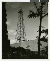
Photograph of the exterior of Hughes Research Laboratories, Culver City, California, circa 1940s
Date
1940 to 1949
Archival Collection
Description
The exterior of Hughes Research Laboratories where rock bits were test-drilled in Culver City, California in the 1940s. Transcribed from note taped to back of photo: "Rock bits are test-drilled in the laboratory under conditions that duplicate, as far as is possible in the laboratory, those encountered in actual drilling. As a result, rotational speeds, loads, and fluid volume are closely controlled. The rig operator occupies a splash-proof booth above the 'cellar floor.' The instruments on his control panel provide for application and measurement of variable axial loading on the drilling bit up to 100,000 lbs., variable rotational speeds up to 400 rpm, measurement of bit penetration over a total vertical travel of 5 feet at rates up to 180 ft. per hour, and torque. On the panel, also, are several controls for the operation of mud pump and other accessory equipment."
Image
Worker fits a new Hughes Jet bit into the drill collar, approximately 1940-1959
Level of Description
File
Archival Collection
Howard Hughes Professional and Aeronautical Photographs
To request this item in person:
Collection Number: PH-00321
Collection Name: Howard Hughes Professional and Aeronautical Photographs
Box/Folder: Folder 16
Collection Name: Howard Hughes Professional and Aeronautical Photographs
Box/Folder: Folder 16
Archival Component
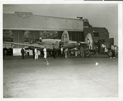
Photograph of people surrounding the Lockheed 14 aircraft, New York, July 9, 1938
Date
1938-07-09
Archival Collection
Description
The black and white view of unidentified people surrounding the Lockheed 14 aircraft. Typed on a piece of paper attached to the image: "Rolling Howard Hughes' plane out of hangar at Floyd Bennett Field, with Lt. Thomas Thurlow, one of the navigators, calibrating the compass. 7/9/38."
Image
Central Park, New York City, New York: panoramic photograph, 1981 May 31
Level of Description
Item
Archival Collection
Bob Paluzzi Panoramic Photographs
To request this item in person:
Collection Number: PH-00414
Collection Name: Bob Paluzzi Panoramic Photographs
Box/Folder: Box 07, Digital File 00
Collection Name: Bob Paluzzi Panoramic Photographs
Box/Folder: Box 07, Digital File 00
Archival Component
Howard Hughes and Edward Lund at the Newark, New Jersey airport, 1937 January 19
Level of Description
File
Archival Collection
Howard Hughes Public Relations Photograph Collection
To request this item in person:
Collection Number: PH-00373
Collection Name: Howard Hughes Public Relations Photograph Collection
Box/Folder: Folder 02
Collection Name: Howard Hughes Public Relations Photograph Collection
Box/Folder: Folder 02
Archival Component
Planning Two New Community Centers, 2000 July 14
Level of Description
File
Archival Collection
Jewish Nevada Records
To request this item in person:
Collection Number: MS-00602
Collection Name: Jewish Nevada Records
Box/Folder: Box 12
Collection Name: Jewish Nevada Records
Box/Folder: Box 12
Archival Component

Photograph of the Lockheed 14 aircraft at Floyd Bennett Field, New York, July 10, 1938
Date
1938-07-10
Archival Collection
Description
The black and white view of the Lockheed 14 aircraft being surrounded by people at Floyd Bennett Field in New York.
Image
Weaver, Randy, New York Life, 1986 July 08
Level of Description
File
Archival Collection
Frank Mitrani Photographs
To request this item in person:
Collection Number: PH-00332
Collection Name: Frank Mitrani Photographs
Box/Folder: Box 20
Collection Name: Frank Mitrani Photographs
Box/Folder: Box 20
Archival Component