Search the Special Collections and Archives Portal
Search Results
Risi, Sue, Hughes Airwest, 1977 March 15
Level of Description
File
Archival Collection
Frank Mitrani Photographs
To request this item in person:
Collection Number: PH-00332
Collection Name: Frank Mitrani Photographs
Box/Folder: Box 06
Collection Name: Frank Mitrani Photographs
Box/Folder: Box 06
Archival Component
View of New York City from New Jersey: color slide, 1943
Level of Description
Item
Archival Collection
Larry Fotine Music collection
To request this item in person:
Collection Number: MS-01179
Collection Name: Larry Fotine Music collection
Box/Folder: Digital File 00
Collection Name: Larry Fotine Music collection
Box/Folder: Digital File 00
Archival Component
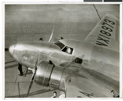
Photograph of Howard Hughes in his Lockheed 14 aircraft, Floyd Bennett Field, New York, 1938
Date
1938
Archival Collection
Description
The black and white view of Howard Hughes in the cockpit of the Lockheed 14 aircraft.
Image
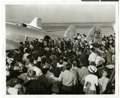
Photograph of Howard Hughes and his crew in Floyd Bennett Field, New York, July 10, 1938
Date
1938-07-10
Archival Collection
Description
The black and white view of Howard Hughes and his crew surrounded by a crowd before they take off from Floyd Bennett Airport in New York.
Image
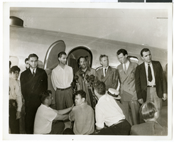
Photograph of Howard Hughes and his crew in Floyd Bennett Field, New York, July 10, 1938
Date
1938-07-10
Archival Collection
Description
The black and white view of Howard Hughes and his crew surrounded by a crowd before they take off from Floyd Bennett Airport in New York.
Image
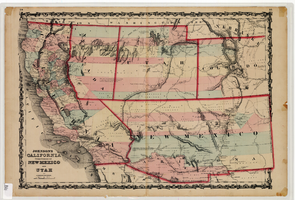
Map of California and territories of New Mexico and Utah, circa 1861
Date
1859 to 1862
Description
'Compiled, drawn, and engraved under the supervision of J.H. Colton and A.J. Johnson.' Relief shown by hachures and spot heights. Scale [ca. 1:3,041,280]. 1 in. to approx. 48 miles (W 124°--W 103°/N 42°--N 31°). Hand colored
Prime meridians: Greenwich and Washington
Plates 54 & 55 removed from Johnson's New illustrated family atlas of the world, with descriptions geographical, statistical and historical ... New York, 1862
Title page of atlas.
Prime meridians: Greenwich and Washington
Plates 54 & 55 removed from Johnson's New illustrated family atlas of the world, with descriptions geographical, statistical and historical ... New York, 1862
Title page of atlas.
Image
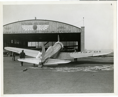
Photograph of Howard Hughes' Northrop Gamma Racer, Newark, New Jersey, January 1936
Date
1936-01
Archival Collection
Description
Black and white photograph of unidentified men positioning aircraft.
Image
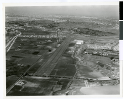
Aerial photograph of Hughes Airport, Culver City, California, circa 1940s-1950s
Date
1940 to 1959
Archival Collection
Description
Aerial view of Hughes Airport in Culver City, now Playa Vista, California. This private airport was owned by Howard Hughes and used for projects of the Hughes Aircraft Company and Hughes Tool Company. Lincoln Boulevard can be seen in the foreground, and on the left are Jefferson Boulevard and Ballona Creek.
Image
New York Mine, Silver City, Nevada
Level of Description
File
Archival Collection
Mary Griffith Toleno Photograph Collection
To request this item in person:
Collection Number: PH-00021
Collection Name: Mary Griffith Toleno Photograph Collection
Box/Folder: N/A
Collection Name: Mary Griffith Toleno Photograph Collection
Box/Folder: N/A
Archival Component
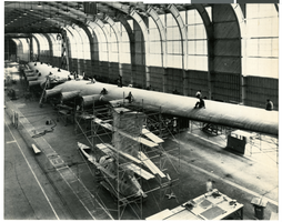
Photograph of the Hughes Flying Boat wing assembly, Culver City, California, circa 1942-46
Date
1942 to 1946
Archival Collection
Description
The Hughes Aircraft HK-1 or "Flying Boat" wing assembly being completed in a hangar in Hughes' factory in Culver City.
Image
Pagination
Refine my results
Content Type
Creator or Contributor
Subject
Archival Collection
Digital Project
Resource Type
Year
Material Type
Place
Language
Records Classification
