Search Results
Lincoln County Archaeological Initiative Collection
Identifier
Abstract
The Lincoln County Archaeological Initiative Collection (2016-2019) contains digital files of oral histories collected as part of A Ranching and Farming Context for Lincoln County, Nevada, ca. 1857 to 1934 (Oliver et al. 2018). The collection consists of thirteen digital oral history recordings and corresponding transcripts, as well as a final report of phase one of the project. The entire collection is digital files.
Archival Collection
Marcus Mason oral history interview
Identifier
Abstract
Oral history interview with Marcus Mason conducted by Leon Green on February 04, 2013 for the African Americans in Las Vegas: a Collaborative Oral History Project. Mason talks about his childhood in Las Vegas, Nevada, his parents’ past occupations, and how his religious upbringing influenced his career choices as an adult.
Archival Collection
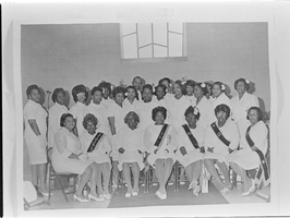
Set of photographs including E. Lyles, and copies for Mrs. James Elliott: image 001
Date
Archival Collection
Image
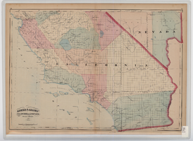
Map of southern California and southern Nevada, 1872
Date
Description
Image

Map of Las Vegas and vicinity, Clark County, Nevada, November 1952
Date
Description
Image
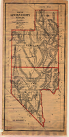
Map of Lincoln County, Nevada, 1908
Date
Description
'Map of Lincoln County, Nevada. Compiled by H.E. Freudenthal from official surveys. Copyright, 1908, by H.E. Freudenthal.' Relief shown by hachures and spot heights. Shows range and township grid. Shows towns, railroads, proposed railroads, wagon roads and springs. Scale [ca. 1:380,160]. 1 in. to approx. 6 miles (W 116°--W 114°/N 39°--N 35°).
Image

Map of the 328 foot level of the Combination Mine, Goldfield, Nevada, circa 1902-1908
Date
Description
Image

Map of underground workings in Potosi and Central Lodes, May 1906
Date
Description
Image