Search Results

Map of California and territories of New Mexico and Utah, circa 1861
Date
1856 to 1866
Description
40 x 60 cm. Relief shown by hachures and spot heights. Prime meridians: Greenwich and Washington. Atlas plate numbers 54 and 55 in the upper corners. Shows forts, trails, exploration routes, drainage, mail steamship routes, physical features, Indian tribes, and historic sites. The geographic region of Southwest is referred to as the New Southwest. Original publisher: Johnson .
Image
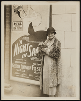
Grace Hayes in front of a playbill posted on the 44th Street Theatre in New York: photographic print
Date
1927
Archival Collection
Description
Grace Hayes in front of a playbill posted on the 44th Street Theatre in New York. She is wearing a patterned coat and small black hat and is holding a small dog.
Image
DirecTV "Hughes Interview B-Roll" with New Logo, 2001 May 07
Level of Description
File
Archival Collection
Hughes Electronics Corporation Records
To request this item in person:
Collection Number: MS-00485
Collection Name: Hughes Electronics Corporation Records
Box/Folder: Box 14
Collection Name: Hughes Electronics Corporation Records
Box/Folder: Box 14
Archival Component
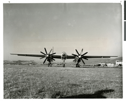
Photograph of the first XF-11 plane at the Hughes Airport, Culver City, California, July 3, 1947
Date
1946-07-03
Archival Collection
Description
The XF-11 plane before its first flight at the Hughes Airport in Culver City, California.
Image

Map of California, Utah, Nevada, Colorado, New Mexico and Arizona, 1864
Date
1864
Description
'Johnson's California, with Utah, Nevada, Colorado, New Mexico, and Arizona, published by Johnson and Ward.' 'Entered according to Act of Congress in the Year 1864 by A.J. Johnson in the Clerks Office of the District Court of the United States for the southern district of New York.' Atlas page numbers in upper margin: 66-67. This is probably plate 67 from Johnson's New Illustrated Family Atlas, published in New York by Johnson & Ward in 1864. Shows natural features, locations of Indian tribes, proposed railroad routes, routes of explorers, trails, county boundaries and populated places ; "." ; Relief shown by hachures ; Prime meridians: Greenwich and Washington ; In top margin: 66-67 ; Hand colored ; On verso: Historical and statistical view of Mexico and central America (p. 79) and Historical and statistical view of the United States, 1860 (p. 78) Scale [ca. 1:3,484,800]. 1 in. to ca. 55 miles (W 124°--W 102°/N 42°--N 32°)
Text
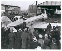
Photograph of Howard Hughes leaving the Northrop Gamma Racer, Newark, New Jersey, January 13, 1936
Date
1936-01-13
Archival Collection
Description
Howard Hughes leaving the cockpit of a Northrop Gamma, surrounded by a crowd at Newark New Jersey Airport. Hughes set a coast-to-coast speed record. A bank of microphones and a movie camera are seen beside the plane.
Image
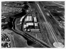
Aerial photograph of Hughes Airport, Culver City, California, circa early 1960s
Date
1960 to 1965
Archival Collection
Description
Aerial view of the airport at Hughes' aircraft plant in Culver City, California. The airport's runway was in operation from 1941 to 1985.
Image
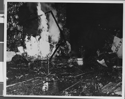
Photograph of crash of Howard Hughes' XF-11, Culver City, California, July 07, 1946
Date
1946-07-07
Archival Collection
Description
A view of the near-fatal crash of Howard Hughes' XF-11 in Culver City, California.
Image
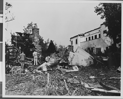
Photograph of crash of Howard Hughes' XF-11, Culver City, California, July 07, 1946
Date
1946-07-07
Archival Collection
Description
A view of the near-fatal crash of Howard Hughes' XF-11 in Culver City, California.
Image
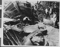
Photograph of crash of Howard Hughes' XF-11, Culver City, California, July 07, 1946
Date
1946-07-07
Archival Collection
Description
A view of the near-fatal crash of Howard Hughes' XF-11 in Culver City, California.
Image