Search Results
Hughes Productions and Hughes Tool Company regarding The Outlaw film rights, 1955 July 25 to 1962 April 17
Level of Description
File
Archival Collection
Howard Hughes Film Production Records
To request this item in person:
Collection Number: MS-01036
Collection Name: Howard Hughes Film Production Records
Box/Folder: Box 156 (Restrictions apply)
Collection Name: Howard Hughes Film Production Records
Box/Folder: Box 156 (Restrictions apply)
Archival Component
Frederick Hugh Thatcher oral history interview summary, 2006 July 04
Level of Description
File
Archival Collection
Jarbidge, Nevada Community Archives Collection
To request this item in person:
Collection Number: MS-01122
Collection Name: Jarbidge, Nevada Community Archives Collection
Box/Folder: Box 01
Collection Name: Jarbidge, Nevada Community Archives Collection
Box/Folder: Box 01
Archival Component

Map of California, Utah, Nevada, Colorado, New Mexico and Arizona, circa 1867
Date
1865 to 1869
Description
39 x 56 cm. Relief shown by hachures. "Entered according to act of Congress in the year 1864, by A.J. Johnson in the Clerks Office of the United States for the Southern District of New York." Atlas page numbers in upper margin: 67-68. Primer meridians: Greenwich and Washington, D.C. On verso: History and statistical view of the West India islands or Columbian Archipelago and Historical and statistical view of Mexico and Central America. Shows proposed railroads, locations of Indian tribes, natural features, counties, mines, mail routes, trails and routes of exploring expeditions. Has decorative border. Southern part of Nevada was added to the state in 1867 and is part of Nevada on this map, but Lincoln County was established in 1867 and is not on this map. This map was still probably published in 1867 in spite of someone's having written "1864" in pencil in the lower right corner of the Library's copy. Original publisher: A.J. Johnson.
Image
Inventory of equipment, 1931 July 27 to 1931 August 15
Level of Description
File
Archival Collection
Howard Hughes Film Production Records
To request this item in person:
Collection Number: MS-01036
Collection Name: Howard Hughes Film Production Records
Box/Folder: Box 577 (Restrictions apply)
Collection Name: Howard Hughes Film Production Records
Box/Folder: Box 577 (Restrictions apply)
Archival Component
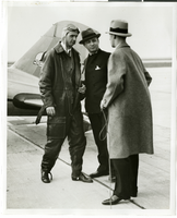
Photograph of Howard Hughes, Albert Lodwick, and unidentified man at Floyd Bennett Field, New York, April 21, 1936
Date
1936-04-21
Archival Collection
Description
Howard Hughes, Albert Lodwick, and an unidentified man at Floyd Bennett Field after record flight from Miami to New York.
Image
Structural drawings, as existing sheets S2.2-S15.65, 1980 July 15
Level of Description
File
Scope and Contents
This set includes drawings by Independent, Sykes, Kiker, and Thomas (manufacturer).
Archival Collection
Martin Stern Architectural Records
To request this item in person:
Collection Number: MS-00382
Collection Name: Martin Stern Architectural Records
Box/Folder: Roll 444
Collection Name: Martin Stern Architectural Records
Box/Folder: Roll 444
Archival Component

Photograph of Hughes Flying Boat section being moved to the Los Angeles Harbor, June 15, 1946
Date
1946-06-15
Archival Collection
Description
A section of Howard Hughes' Flying Boat being moved (with a police escort) from the Hughes Aircraft plant in Culver City, California to Terminal Island in the Los Angeles Harbor where the plane was assembled in June of 1946.
Image

Photograph of Howard Hughes' Flying Boat being moved to the Los Angeles Harbor, June 15, 1946
Date
1946-06-15
Archival Collection
Description
A section of Howard Hughes' Flying Boat being moved (with a police escort) from the Hughes Aircraft plant in Culver City, California to Terminal Island in the Los Angeles Harbor where the plane was assembled in June of 1946. Date stamped on back of photo.
Image
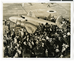
Photograph of the Lockheed 14 aircraft at Floyd Bennett Field, New York, July 10, 1938
Date
1938-07-10
Archival Collection
Description
The black and white view of the Lockheed 14 aircraft being surrounded by people at Floyd Bennett Field in New York.
Image
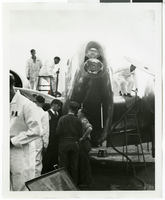
Photograph of the Lockheed 14 aircraft, Fairbanks, Alaska, July 15, 1938
Date
1938-07-15
Archival Collection
Description
The black and white view of the nose of the Lockheed 14 aircraft while it is being refueled for Howard Hughes' Around the World trip. Mechanics can be seen standing on top of and beside the plane.
Image