Search Results
Hughes H-1 Racer, Newark, New Jersey, 1937 January 19
Level of Description
File
Archival Collection
Howard Hughes Public Relations Photograph Collection
To request this item in person:
Collection Number: PH-00373
Collection Name: Howard Hughes Public Relations Photograph Collection
Box/Folder: Folder 02
Collection Name: Howard Hughes Public Relations Photograph Collection
Box/Folder: Folder 02
Archival Component
Howard Hughes, wearing pilot's overalls and gear with parachute, at the tail of the Hughes H-1 Racer, in Newark, New Jersey, 1937
Level of Description
File
Archival Collection
Howard Hughes Professional and Aeronautical Photographs
To request this item in person:
Collection Number: PH-00321
Collection Name: Howard Hughes Professional and Aeronautical Photographs
Box/Folder: Folder 04
Collection Name: Howard Hughes Professional and Aeronautical Photographs
Box/Folder: Folder 04
Archival Component
Lockheed 14 in New York, 1938 July 09
Level of Description
File
Archival Collection
Howard Hughes Public Relations Photograph Collection
To request this item in person:
Collection Number: PH-00373
Collection Name: Howard Hughes Public Relations Photograph Collection
Box/Folder: Folder 05
Collection Name: Howard Hughes Public Relations Photograph Collection
Box/Folder: Folder 05
Archival Component
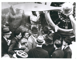
Photograph of Howard Hughes with Lockheed-14 plane, Le Bourget, France, July 11, 1938
Date
1938-07-11
Archival Collection
Description
Howard Hughes surrounded by a crowd at Le Bourget Field in France, in front of a Lockheed-14, July 11, 1938. Le Bourget (Airport : Le Bourget, France)
Image

Map of California and territories of New Mexico and Utah, circa 1861
Date
1859 to 1862
Description
'Compiled, drawn, and engraved under the supervision of J.H. Colton and A.J. Johnson.' Relief shown by hachures and spot heights. Scale [ca. 1:3,041,280]. 1 in. to approx. 48 miles (W 124°--W 103°/N 42°--N 31°). Hand coloredPrime meridians: Greenwich and WashingtonPlates 54 & 55 removed from Johnson's New illustrated family atlas of the world, with descriptions geographical, statistical and historical ... New York, 1862Title page of atlas.
Image
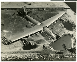
Aerial photograph of Hughes' Hercules flying boat aircraft, Los Angeles (Calif.), July 16, 1947
Date
1947-07-16
Archival Collection
Description
Howard Hughes' flying boat docked near the waters of Los Angeles Harbor, taken on July 16, 1947.
Image
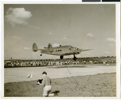
Photograph of Howard Hughes's plane taking off, Minneapolis, Minnesota, July 14, 1938
Date
1938-07-14
Archival Collection
Description
The black and white view of the Lockheed 14 aircraft taking off on a part of Howard Hughes' Around the World flight. Typed onto a piece of paper attached to the image: "The Howard Hughes plane taking off from Minneapolis on their way to New York to complete a round the world flight."
Image
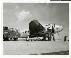
Photograph of mechanics with the Lockheed 14 aircraft, New York, July 10, 1938
Date
1938-07-10
Archival Collection
Description
The black and white view of a plane used by Howard Hughes being fueled up at Floyd Bennett Field in New York.
Image
Howard Hughes in a parade in Houston, Texas, 1938 July 30
Level of Description
File
Archival Collection
Howard Hughes Professional and Aeronautical Photographs
To request this item in person:
Collection Number: PH-00321
Collection Name: Howard Hughes Professional and Aeronautical Photographs
Box/Folder: Folder 04
Collection Name: Howard Hughes Professional and Aeronautical Photographs
Box/Folder: Folder 04
Archival Component