Search the Special Collections and Archives Portal
Search Results
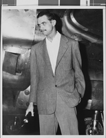
Howard Hughes and his crew in Floyd Bennett Field, New York, 1938 July 10
Level of Description
Archival Collection
Collection Name: Howard Hughes Public Relations Photograph Collection
Box/Folder: Folder 06
Archival Component
Howard Hughes and his crew in Floyd Bennett Field, New York, 1938 July 10
Level of Description
Archival Collection
Collection Name: Howard Hughes Public Relations Photograph Collection
Box/Folder: Folder 06
Archival Component
Howard Hughes and his crew in Floyd Bennett Field, New York, 1938 July 10
Level of Description
Archival Collection
Collection Name: Howard Hughes Public Relations Photograph Collection
Box/Folder: Folder 06
Archival Component
Howard Hughes and Grover Whalen at Floyd Bennett Field, New York, 1938 July 10
Level of Description
Archival Collection
Collection Name: Howard Hughes Public Relations Photograph Collection
Box/Folder: Folder 06
Archival Component
Howard Hughes and Grover Whalen at Floyd Bennett Field, New York, 1938 July 10
Level of Description
Archival Collection
Collection Name: Howard Hughes Public Relations Photograph Collection
Box/Folder: Folder 06
Archival Component
New York-New York Hotel and Casino 9-11 Heroes Tribute Collection
Identifier
Abstract
The New York-New York Hotel and Casino 9-11 Heroes Tribute Collection consists of materials from the "Heroes of 9-11" display that was at the New York-New York Hotel and Casino in Las Vegas, Nevada from 2001 to 2012. The materials primarily consist of more than 5,000 t-shirts left at the memorial by visitors to Las Vegas, mostly from fire departments and law enforcement agencies from around the United States. Visitors left shirts and other items at the memorial as a sign of respect for the men and women who died during the terrorist attacks in New York City and Washington, D.C. on September 11, 2001. The collection also houses memorabilia and other items left at the memorial, including flags, hats, pins, buttons, flowers, and embroidered emblems and insignias. The materials also contain documentation of the memorial, including promotional and press materials, video recordings from the news media, photographs, and newspaper articles.
Archival Collection
Howard Hughes emerging from his airplane after landing in New York, 1947 April
Level of Description
Archival Collection
Collection Name: Howard Hughes Professional and Aeronautical Photographs
Box/Folder: Folder 02, Flat File 01
Archival Component
Proposed Hotel, Atlantic City Convention Center: Atlantic City, New Jersey, 1976 November 22
Level of Description
Archival Collection
Collection Name: Martin Stern Architectural Records
Box/Folder: N/A
Archival Component
#69250: Melissa Rorie, new faculty member on August 15, 2013, 2013 August 15
Level of Description
Archival Collection
Collection Name: University of Nevada, Las Vegas Creative Services Records (2010s)
Box/Folder: Digital File 00
Archival Component

Photograph of Howard Hughes, Los Angeles, September 11, 1946
Date
Archival Collection
Description
Image
