Search the Special Collections and Archives Portal
Search Results

Photograph of the landing of Howard Hughes' Lockheed 14 aircraft, New York, July 14, 1938
Date
1938-07-14
Archival Collection
Description
The black and white, view of Howard Hughes' Lockheed 14 aircraft performing its final landing on the Round the World flight at Floyd Bennett Airport, New York. Typed onto a piece of paper attached to the image: "Scene at Floyd Bennett Field as Howard Hughes and his crew landed after completing a round the world flight..... 7-14-38. (Press Association)"
Image
Report: "Marketing Casino Gambling and a Local Lottery in New York City" by the Council of the City of New York for the Committee on Economic Development, 1991
Level of Description
File
Archival Collection
Eugene Martin Christiansen Papers
To request this item in person:
Collection Number: MS-00561
Collection Name: Eugene Martin Christiansen Papers
Box/Folder: Box 163
Collection Name: Eugene Martin Christiansen Papers
Box/Folder: Box 163
Archival Component
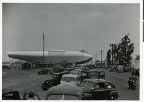
Photograph of Hughes Flying Boat section being moved to the Los Angeles Harbor, June 15, 1946
Date
1946-06-15
Archival Collection
Description
A section of Howard Hughes' Flying Boat being moved (with a police escort) from the Hughes Aircraft plant in Culver City, California to Terminal Island in the Los Angeles Harbor where the plane was assembled in June of 1946.
Image
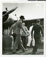
Photograph of Howard Hughes and the Lockheed 14 aircraft, Fairbanks, Alaska, July 15, 1938
Date
1938-07-15
Archival Collection
Description
The black and white view of Howard Hughes walking with other unidentified men toward the Lockheed 14 aircraft that was then being refueled. Hughes was then on his Around the World Flight where he visited Paris, Moscow, Fairbanks, and Alaska.
Image
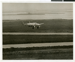
Photograph of the landing of Howard Hughes' Lockheed 14 aircraft, New York, July 14, 1938
Date
1938-07-14
Archival Collection
Description
The black and white, aerial view of Howard Hughes' Lockheed 14 aircraft performing its final landing on the Round the World flight in Floyd Bennett Airport, New York. Typed onto a piece of paper attached to the image: "Flight's End: Floyd Bennett Airport - Howard Hughes' silver monoplane, "World's Fair, 1939," as the skimmed the runway just before landing at 2:37 1/2 p.m., to end a dramatic dash around the world. A minutes later, Hughes and his companions were mobbed by officials. Credit (ACME). 7/14/38."
Image
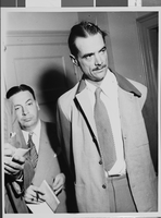
Photograph of Howard Hughes with Senator Harry P. Cain, Culver City, California, August 16, 1947
Date
1947-08-16
Archival Collection
Description
A view of Howard Hughes (right) after being asked about his controversial XF-11 photo reconnaissance plane by Senator Harry Cain (left), Republican of Washington, in Culver City, California.
Image
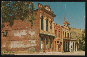
Knights of Pythias and the Miners' Union Hall, Virginia City, Nevada: postcard
Date
1975 (year approximate)
Description
From the Nan Doughty Photograph Collection (PH-00240)
Image
Photograph of the fuselage of the Hughes Flying Boat leaving its Culver City hangar, California, 1946
Date
1946
Archival Collection
Description
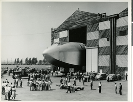
A section of Howard Hughes' "Spruce Goose" or "Flying Boat" being moved (with a police escort) from the Hughes Aircraft plant in Culver City, California to Terminal Island in the Los Angeles Harbor where the plane was assembled in June of 1946.
Image

Photograph of Howard Hughes' Flying Boat being moved to the Los Angeles Harbor, June 15, 1946
Date
1946-06-15
Archival Collection
Description
A section of Howard Hughes' Flying Boat being moved (with a police escort) from the Hughes Aircraft plant in Culver City, California to Terminal Island in the Los Angeles Harbor where the plane was assembled in June of 1946. Date stamped on back of photo.
Image
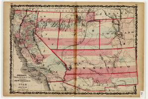
Map of California and Territories of New Mexico and Utah, 1862
Date
1862
Description
Scale [ca. 1:3,231,360. 1 in. to approx. 51 miles] (W 125°00--W 103°30/N 42°00--N 31°45) ; 1 map : hand col. ; 40 x 60 cm., on sheet 46 x 68 cm ; Relief indicated by hachures and spot heights ; Prime meridians: Greenwich and Washington, D.C ; Decorative border ; Hand colored ; Atlas p. numbers in upper margin: 58-59 ; Date est. from territorial borders and county configuration ; Shows natural features, locations of Indian tribes, proposed railroad routes, routes of explorers, trails, county boundaries and populated places ; Johnson and Ward
Image
Pagination
Refine my results
Content Type
Creator or Contributor
Subject
Archival Collection
Digital Project
Resource Type
Year
Material Type
Place
Language
Records Classification
