Search Results
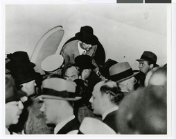
Mayor Fiorello La Guardia on the steps of City Hall receiving Howard Hughes and his crew: Ed Lund, Richard Stoddart, Thomas Thurlow, and Harry Connor, 1938 July 15
Level of Description
File
Archival Collection
Howard Hughes Public Relations Photograph Collection
To request this item in person:
Collection Number: PH-00373
Collection Name: Howard Hughes Public Relations Photograph Collection
Box/Folder: Folder 12
Collection Name: Howard Hughes Public Relations Photograph Collection
Box/Folder: Folder 12
Archival Component
Photograph of Howard Hughes exiting the Lockheed-14 at the Floyd Bennett Airport, New York, July 14, 1938
Date
1938-07-14
Archival Collection
Description
Howard Hughes getting out of cabin door of Lockheed-14 at the Floyd Bennett Airport in New York in 1938.
Image

Map of California and territories of New Mexico and Utah, circa 1861
Date
1859 to 1862
Description
'Compiled, drawn, and engraved under the supervision of J.H. Colton and A.J. Johnson.' Relief shown by hachures and spot heights. Scale [ca. 1:3,041,280]. 1 in. to approx. 48 miles (W 124°--W 103°/N 42°--N 31°). Hand coloredPrime meridians: Greenwich and WashingtonPlates 54 & 55 removed from Johnson's New illustrated family atlas of the world, with descriptions geographical, statistical and historical ... New York, 1862Title page of atlas.
Image
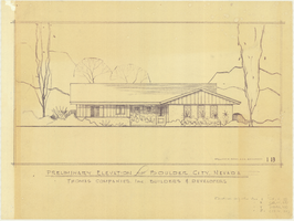
Architectural drawing of residential home in Boulder City, Nevada, preliminary elevation, 1962
Date
1962
Archival Collection
Description
Preliminary drawing of front exterior elevation of ra anch-style residential home in Boulder City, Nevada. Handwritten near lower right: "Elevations only for Plan 1 (1B, 1C, 1D), Plan 2 (2B, 2C, 2D), Plan 4 (4B, 4C, 4D), Plan 5 (5B, 5C, 5D)."
Architecture Period: Mid-Century ModernistImage
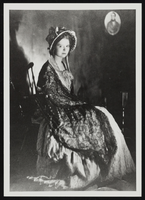
Clara Bow after winning the National Fame and Fortune Contest in New York City, New York: photographic print
Date
1921
Description
From the Nan Doughty Photograph Collection (PH-00240). Clara at age 16.
Image

Photograph of the landing of Howard Hughes' Lockheed 14 aircraft, New York, July 14, 1938
Date
1938-07-14
Archival Collection
Description
The black and white, aerial view of Howard Hughes' Lockheed 14 aircraft preparing for its final landing on its Round the World flight in Floyd Bennett Field, New York.
Image