
Search the Special Collections and Archives Portal

Search Results

Display    Results Per Page
Displaying results 1261 - 1270 of 120900

Shauna Hughes oral history interviews

Identifier

OH-02817

Abstract

Oral history interviews with Shauna Hughes conducted by Stefani Evans and Claytee D. White on August 31, 2016 and October 11, 2016 for the Building Las Vegas Oral History Project. In the first interview, Hughes discusses her early life in New York and later moving to Ohio. She talks about attending John Carroll University, moving to Las Vegas, Nevada in 1982, and being a founding member of the Southern Nevada Association of Women Attorneys. Hughes recalls being appointed Henderson City Attorney, the early development of Green Valley, and the rapid growth of that area. Hughes then describes the Pacific Engineering and Production Company of Nevada (PEPCON) explosion in 1988. In the second interview, Hughes discusses her work as Henderson City Attorney. She describes collaborating with elected city officials, the development of the Galleria Mall, and the establishment of Nevada State College (NSC). Lastly, Hughes talks about community support for new infrastructure in Henderson.

Archival Collection

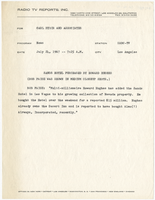
Press release announcing Howard Hughes' purchase of the Sands Hotel

Date

1967-07-24

Description

Press release quoting Bob Paige announcing Howard Hughes' acquistion of the Sands Hotel in Las Vegas.

Text

Map of California, and territories of Utah, Nevada, Colorado, New Mexico and Arizona, 1864

Date

1864

Description

'Johnson's California, also Utah, Nevada, Colorado, New Mexico, and Arizona, published by A.J. Johnson, New York.' 'Entered according to act of Congress in the year 1864, by A.J. Johnson in the Clerks Office of the District Court of the United States for the southern district of New York.' Atlas page numbers in upper margin: 67-68. Relief shown by hachures. Prime meridian: Greenwich and Washington. Shows natural features, locations of Indian tribes, proposed railroad routes, routes of explorers, trails, county boundaries and populated places. Hand colored. On verso: 'Historical and statistical view of the West India Islands or Columbian Archipelago' (p. 80) and 'Historical and statistical view of Mexico and Central America' (p. 79). Scale [ca. 1:3,484,800]. 1 in. to ca. 55 miles (W 124°--W 102°/N 42°--N 32°).

Text

Etna, Lincoln County, Nevada, circa 1938, 1938

Level of Description

File

Archival Collection

Elbert Edwards Photograph Collection
To request this item in person:
Collection Number: PH-00214
Collection Name: Elbert Edwards Photograph Collection
Box/Folder: Folder 02

Archival Component

Hall and Mirrors

Date

1980

Archival Collection

Description

Series II. Folies-Bergere production papers, designs, and photographs -- 15th Edition partial revision -- Set design drawings by Charles Lisanby

Image

#04881: High Tech Meeting at Artemus W. Ham Concert Hall, 1982 December 15

Level of Description

File

Archival Collection

University of Nevada, Las Vegas Creative Services Records (1980s)
To request this item in person:
Collection Number: PH-00388-02
Collection Name: University of Nevada, Las Vegas Creative Services Records (1980s)
Box/Folder: N/A

Archival Component

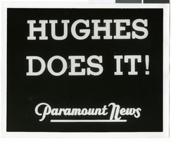
Photograph of a Paramount News headline, 1938

Date

1938-07-14

Description

The words "Hughes does it!" printed against a black background.

Image

#66818: Images for College of Business Banners Inside Beam Hall, 2009 January 15

Level of Description

File

Archival Collection

University of Nevada, Las Vegas Creative Services Records (2000s)
To request this item in person:
Collection Number: PH-00388-04
Collection Name: University of Nevada, Las Vegas Creative Services Records (2000s)
Box/Folder: N/A

Archival Component

Map of California, Utah, Nevada, Colorado, New Mexico and Arizona, circa 1867

Date

1865 to 1869

Description

39 x 56 cm. Relief shown by hachures. "Entered according to act of Congress in the year 1864, by A.J. Johnson in the Clerks Office of the United States for the Southern District of New York." Atlas page numbers in upper margin: 67-68. Primer meridians: Greenwich and Washington, D.C. On verso: History and statistical view of the West India islands or Columbian Archipelago and Historical and statistical view of Mexico and Central America. Shows proposed railroads, locations of Indian tribes, natural features, counties, mines, mail routes, trails and routes of exploring expeditions. Has decorative border. Southern part of Nevada was added to the state in 1867 and is part of Nevada on this map, but Lincoln County was established in 1867 and is not on this map. This map was still probably published in 1867 in spite of someone's having written "1864" in pencil in the lower right corner of the Library's copy. Original publisher: A.J. Johnson.

Image

#58554: Artemus W. Ham Concert Hall Calendar - Music Instrument, 1990 August 15

Level of Description

File

Archival Collection

University of Nevada, Las Vegas Creative Services Records (1990s)
To request this item in person:
Collection Number: PH-00388-03
Collection Name: University of Nevada, Las Vegas Creative Services Records (1990s)
Box/Folder: N/A

Archival Component