Search Results
Howard Hughes and the Lockheed 14 aircraft, Fairbanks, Alaska, 1938 July 15
Level of Description
Archival Collection
Collection Name: Howard Hughes Public Relations Photograph Collection
Box/Folder: Folder 07
Archival Component
Howard Hughes at the celebration of his around-the-world flight, 1938 July 15
Level of Description
Archival Collection
Collection Name: Howard Hughes Public Relations Photograph Collection
Box/Folder: Folder 12
Archival Component
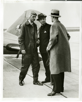
Photograph of Howard Hughes, Albert Lodwick, and unidentified man at Floyd Bennett Field, New York, April 21, 1936
Date
Archival Collection
Description
Image

Plan of proposed new well pipe and fittings for Las Vegas, Nevada, 1936
Date
Archival Collection
Description
Image
Howard Hughes Professional and Aeronautical Photographs
Identifier
Abstract
The Howard Hughes Professional and Aeronautical Photographs contain black-and-white photographs of businessman and entrepreneur Howard Hughes and his companies from 1916 to 1997. The photographs primarily depict Hughes alongside his aircraft, including the XF-11 prototype reconnaissance plane and the HK-1 Hercules, better known as the "Spruce Goose" or "Flying Boat." The photographs also cover the companies owned by Hughes, including Hughes Tool Company, Hughes Aircraft Company, Hughes Electronics Corporation, and RKO Pictures.
Archival Collection
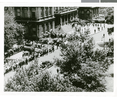
Photographs of crowds at Around-the-World-Flight Parade, New York City (N.Y.), July 15, 1938
Date
Archival Collection
Description
Image
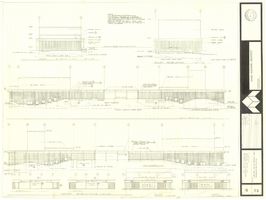
Architectural drawing of concert hall and drama theater, University of Nevada, Las Vegas, exterior elevations, November 5, 1969
Date
Archival Collection
Description
Exterior elevations for the concert hall and drama theater on the University of Nevada, Las Vegas campus, including a connecting courtyard. These buildings would become the Artemus W. Ham Concert Hall and the Judy Bayley Theatre. Sheet 6 of 35. "Drawn by G.T. Checked by K.D. Job number 6828. Scale 1/16" = 1'-0". Date Nov. 5, 1969"
Site Name: University of Nevada, Las Vegas
Address: 4505 S. Maryland Parkway
Image
Adamar of New Jersey License Application, December 15, 1981
Level of Description
Archival Collection
Collection Name: International Association of Gaming Attorneys Collection
Box/Folder: Box 01
Archival Component
Hughes/Echostar Video News Release Corporate Announcement- New Master, 2002 March 07
Level of Description
Archival Collection
Collection Name: Hughes Electronics Corporation Records
Box/Folder: Box 14
Archival Component
Global Works Hughes Electronic Corporation Corporate Runner New AO, 2000 October 23
Level of Description
Archival Collection
Collection Name: Hughes Electronics Corporation Records
Box/Folder: Box 16
Archival Component