Search Results

Map of California, and territories of Utah, Nevada, Colorado, New Mexico and Arizona, 1864
Date
1864
Description
'Johnson's California, also Utah, Nevada, Colorado, New Mexico, and Arizona, published by A.J. Johnson, New York.' 'Entered according to act of Congress in the year 1864, by A.J. Johnson in the Clerks Office of the District Court of the United States for the southern district of New York.' Atlas page numbers in upper margin: 67-68. Relief shown by hachures. Prime meridian: Greenwich and Washington. Shows natural features, locations of Indian tribes, proposed railroad routes, routes of explorers, trails, county boundaries and populated places. Hand colored. On verso: 'Historical and statistical view of the West India Islands or Columbian Archipelago' (p. 80) and 'Historical and statistical view of Mexico and Central America' (p. 79). Scale [ca. 1:3,484,800]. 1 in. to ca. 55 miles (W 124°--W 102°/N 42°--N 32°).
Text
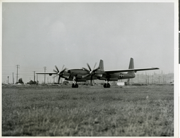
Photograph of the XF-11 as it is about to take off for its first test flight in Culver City, California July 7, 1947
Date
1947
Archival Collection
Description
Transcribed from attachment to photo: "NEW LONG-RANGE PLANE ANNOUNCED CULVER CITY, CALIF., The FX-11 took off today on its first test flight. One of the world's fastest long-range photographic planes, it was designed and built by Howard Hughes in conjunction with Air Materiel Command engineers. It has a wing spread of 101 feet, 4 inches, and is powered by two 3000-horsepower radial engines with eight-bladed contra-rotating propellers. Army officials said it can attain a speed of more than 400 miles per hour and has a ceiling of more than 40,000 feet." Transcribed from photo sleeve: "Howard Hughes sits in the cockpit of the XF-11, a reconnaissance plane that Hughes built and designed in conjunction with Air Materiel Command engineers. Hughes is preparing for his first test flight in Culver City, California July 7, 1947."
Image
Raymond A. Cook, Mortimer Caplin, R. J. Cordiner, and Howard Hughes letters arguing against a claim deeming HHMI's assets as excessive, 1954 July 15 to 1956 March 26
Level of Description
File
Archival Collection
Howard Hughes Film Production Records
To request this item in person:
Collection Number: MS-01036
Collection Name: Howard Hughes Film Production Records
Box/Folder: Box 551 (Restrictions apply)
Collection Name: Howard Hughes Film Production Records
Box/Folder: Box 551 (Restrictions apply)
Archival Component
Letter from A. S. Halsted to W. H. Comstock, July 15, 1922
Date
1922-07-15
Archival Collection
Description
Halsted advises on legal interpretations of use of force in guarding railroad property.
Text
Letter from Hugh A. Shamberger (Carson City) to Las Vegas Land and Water Company (Las Vegas), June 21, 1950
Date
1950-06-21
Archival Collection
Description
List of wells owned by the Las Vegas Land and Water Company and the amount of water granted to each.
Text
Hughes Productions and Hughes Tool Company regarding The Outlaw film rights, 1955 July 25 to 1962 April 17
Level of Description
File
Archival Collection
Howard Hughes Film Production Records
To request this item in person:
Collection Number: MS-01036
Collection Name: Howard Hughes Film Production Records
Box/Folder: Box 156 (Restrictions apply)
Collection Name: Howard Hughes Film Production Records
Box/Folder: Box 156 (Restrictions apply)
Archival Component
Frederick Hugh Thatcher oral history interview summary, 2006 July 04
Level of Description
File
Archival Collection
Jarbidge, Nevada Community Archives Collection
To request this item in person:
Collection Number: MS-01122
Collection Name: Jarbidge, Nevada Community Archives Collection
Box/Folder: Box 01
Collection Name: Jarbidge, Nevada Community Archives Collection
Box/Folder: Box 01
Archival Component

Map of California, Utah, Nevada, Colorado, New Mexico and Arizona, circa 1867
Date
1865 to 1869
Description
39 x 56 cm. Relief shown by hachures. "Entered according to act of Congress in the year 1864, by A.J. Johnson in the Clerks Office of the United States for the Southern District of New York." Atlas page numbers in upper margin: 67-68. Primer meridians: Greenwich and Washington, D.C. On verso: History and statistical view of the West India islands or Columbian Archipelago and Historical and statistical view of Mexico and Central America. Shows proposed railroads, locations of Indian tribes, natural features, counties, mines, mail routes, trails and routes of exploring expeditions. Has decorative border. Southern part of Nevada was added to the state in 1867 and is part of Nevada on this map, but Lincoln County was established in 1867 and is not on this map. This map was still probably published in 1867 in spite of someone's having written "1864" in pencil in the lower right corner of the Library's copy. Original publisher: A.J. Johnson.
Image
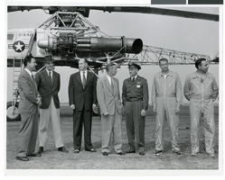
Photograph of Howard Hughes and others with a XH-17 helicopter, Culver City, California, October 23, 1952
Date
1952-10-23
Archival Collection
Description
Howard Hughes (second from left) standing in front of the experimental helicopter XH-17, Flying Crane in October 1952. From left to right: Rea Hopper, Director of the Aeronautical Division, Hughes Aircraft Company; Howard Hughes; Clyde Jones, Director of Engineering, Hughes Tool Company Aeronautical Division; Warren Reed, Assistant; Colonel Carl E. Jackson, Air Research and Development Headquarters, Baltimore; Gale J. Moore, Pilot; and Chal Bowen, Flight Engineer/Co-pilot.
Image
Inventory of equipment, 1931 July 27 to 1931 August 15
Level of Description
File
Archival Collection
Howard Hughes Film Production Records
To request this item in person:
Collection Number: MS-01036
Collection Name: Howard Hughes Film Production Records
Box/Folder: Box 577 (Restrictions apply)
Collection Name: Howard Hughes Film Production Records
Box/Folder: Box 577 (Restrictions apply)
Archival Component