Search Results
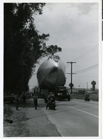
Photograph of a section of Hughes Flying Boat en route to the Los Angeles Harbor, June 15, 1946
Date
Archival Collection
Description
Image
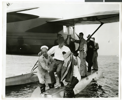
Photograph of Howard Hughes at a U.S. Coast Guard Station, January 15, 1938
Date
Archival Collection
Description
Image
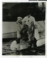
Photograph of Howard Hughes at a U.S. Coast Guard Station, January 15, 1938
Date
Archival Collection
Description
Image
Harrah's Grand, Atlantic City, New Jersey, 2001
Level of Description
Archival Collection
Collection Name: Robert Beckmann Photographs
Box/Folder: Box 02
Archival Component
Integrated Systems Engineering, 1988 July 15
Level of Description
Archival Collection
Collection Name: Frank Mitrani Photographs
Box/Folder: Box 09
Archival Component
#64226: New Leadership Nevada, 2004 June 15
Level of Description
Archival Collection
Collection Name: University of Nevada, Las Vegas Creative Services Records (2000s)
Box/Folder: N/A
Archival Component

City map of Las Vegas, 1973
Date
Description
Image
Hughes Electronics Corporation Records
Identifier
Abstract
The Hughes Electronics Corporation Records (1935-2021) contain the files and publications of the corporate communications department and records donated by Robert K. Roney, a leading engineer at Hughes. These records document the growth of the company in Southern California, from building experimental aircraft for Howard Hughes, to developing and manufacturing radar and guided missile systems for the United States military and NATO forces, to developing and manufacturing communication satellites and space probes for NASA, and becoming the largest manufacturer of communication satellites and provider of satellite TV. The collection contains press releases, executive biographies, executive speeches, annual reports, corporate directories, organizational charts, correspondence files, technical reports and notes, promotional materials, as well as articles and publications detailing the history of the company. The collection also includes audiovisual materials and photographs. The audiovisual series details the history of the company through news footage and documentaries about Howard Hughes, aviation, corporate mergers, interviews with executives and promotional videos.
Archival Collection
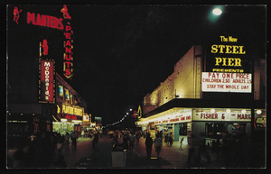
Nighttime view of Atlantic City, New Jersey: postcard
Date
Archival Collection
Description
Image

Map of California and Territories of New Mexico and Utah, 1862
Date
Description
Image