Search Results
Howard Hughes, co-pilot Joseph Bartles, and navigator Robert Stevens at the controls of their Lockheed Constellation after landing at LaGuardia Field in New York City, 1946 February 15
Level of Description
File
Archival Collection
Howard Hughes Public Relations Photograph Collection
To request this item in person:
Collection Number: PH-00373
Collection Name: Howard Hughes Public Relations Photograph Collection
Box/Folder: Folder 20
Collection Name: Howard Hughes Public Relations Photograph Collection
Box/Folder: Folder 20
Archival Component
Script edits from Douglass Biggs and Howard Hughes, 1931 July 16
Level of Description
File
Archival Collection
Howard Hughes Film Production Records
To request this item in person:
Collection Number: MS-01036
Collection Name: Howard Hughes Film Production Records
Box/Folder: Box 043 (Restrictions apply)
Collection Name: Howard Hughes Film Production Records
Box/Folder: Box 043 (Restrictions apply)
Archival Component
Script edits from Howard Hughes and Robert E. Sherwood, 1931 July 31
Level of Description
File
Archival Collection
Howard Hughes Film Production Records
To request this item in person:
Collection Number: MS-01036
Collection Name: Howard Hughes Film Production Records
Box/Folder: Box 043 (Restrictions apply)
Collection Name: Howard Hughes Film Production Records
Box/Folder: Box 043 (Restrictions apply)
Archival Component
Roy Pomeroy option agreement with Hughes Development Company for Multicolor equipment, 1931 July 16 to 1931 July 21
Level of Description
File
Archival Collection
Howard Hughes Film Production Records
To request this item in person:
Collection Number: MS-01036
Collection Name: Howard Hughes Film Production Records
Box/Folder: Box 516 (Restrictions apply)
Collection Name: Howard Hughes Film Production Records
Box/Folder: Box 516 (Restrictions apply)
Archival Component

Map of California, Nevada, Utah, Colorado, Arizona & New Mexico, circa 1867
Date
1865 to 1869
Description
39 x 62 cm. Relief shown by hachures and spot heights. Prime meridian: Greenwich and Washington. Hand colored. Shows natural features, populated places, routes of mail steamships, routes of explorers, locations of Indian tribes, railroad routes, and proposed railroad routes. In top margin: No. 80-81. On verso: New Mexico, Arizona, Colorado, Idaho, Dakota (statistics and other information) and The state of California (statistics and other information). Original publisher: G.W. and C.B. Colton.
Image

Map of California, and territories of Utah, Nevada, Colorado, New Mexico and Arizona, 1864
Date
1864
Description
'Johnson's California, also Utah, Nevada, Colorado, New Mexico, and Arizona, published by A.J. Johnson, New York.' 'Entered according to act of Congress in the year 1864, by A.J. Johnson in the Clerks Office of the District Court of the United States for the southern district of New York.' Atlas page numbers in upper margin: 67-68. Relief shown by hachures. Prime meridian: Greenwich and Washington. Shows natural features, locations of Indian tribes, proposed railroad routes, routes of explorers, trails, county boundaries and populated places. Hand colored. On verso: 'Historical and statistical view of the West India Islands or Columbian Archipelago' (p. 80) and 'Historical and statistical view of Mexico and Central America' (p. 79). Scale [ca. 1:3,484,800]. 1 in. to ca. 55 miles (W 124°--W 102°/N 42°--N 32°).
Text
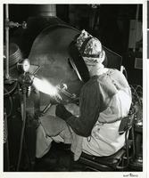
Photograph of new atomic-hydrogen welding process, Hughes Tool Company, Houston, Texas, circa 1929
Date
1929
Archival Collection
Description
Transcribed from press release attached to back of photo: "PENETRATES EARTH 16,000 FEET A surface approaching the hardness of the diamond is applied by a new atomic-hydrogen welding process to the teeth of a rock bit drill at the Hughes Tool Company plant in Houston, Texas, owned by Howard Hughes, noted aircraft designer-flyer. The first Hughes rock bit revolutionized oil drilling practices in this nation several decades ago, making possible recovery of oil beneath hard rock formations at great depths. Most recent models have penetrated the earth below 16,000 feet. Hughes drills are used in 50 foreign countries. NOTE: The atomic-hydrogen process differs from other arc-welding processes in that the arc is formed between two electrodes, rather than one electrode and the work." The patent on the atomic-hydrogen process was awarded October 29, 1929.
Image
Lockheed 14, Floyd Bennett Field, New York, 1938 July 10
Level of Description
File
Archival Collection
Howard Hughes Public Relations Photograph Collection
To request this item in person:
Collection Number: PH-00373
Collection Name: Howard Hughes Public Relations Photograph Collection
Box/Folder: Folder 06
Collection Name: Howard Hughes Public Relations Photograph Collection
Box/Folder: Folder 06
Archival Component
Hiram "Tommy" Thurlow on the Lockheed 14, New York, 1938 July 09
Level of Description
File
Archival Collection
Howard Hughes Public Relations Photograph Collection
To request this item in person:
Collection Number: PH-00373
Collection Name: Howard Hughes Public Relations Photograph Collection
Box/Folder: Folder 05
Collection Name: Howard Hughes Public Relations Photograph Collection
Box/Folder: Folder 05
Archival Component