Search Results
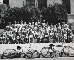
Photograph of children at the Boulder City Library, Nevada, circa 1950s
Date
1950 to 1959
Archival Collection
Description
Black and white image of a group of children participating in a summer reading program at the Boulder City Library. The children are all holding certificates possibly applauding them for their reading achievements.
Image
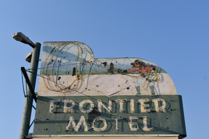
Frontier Motel double mounted sign, Carson City, Nevada
Date
2016 (year approximate) to 2020 (year approximate)
Archival Collection
Description
View of the sign for the Frontier Motel during the day with unlit neon.
1718 N Carson St, Carson City, NV 89701
Image
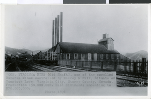
Postcard of Consolidated Virginia mine, Virginia City, Nevada, 1891
Date
1891
Archival Collection
Description
An exterior view of a Consolidated Virginia mine in Virginia City, Nevada. Description provided with image: "Con. Virginia Mine (Old Shaft), one of the so-called Bonanza Mines controlled by Mackey & Fair, Situate on Comstock Lode, Virginia City, Storey County, Nevada. Production 150,000,000. Paid dividends amounting to $78,000,000. Photo 1891."
Image
Hoover Dam Service Bureau and Boulder City Theatre on Arizona Street in Boulder City, Nevada, approximately 1936-1938
Level of Description
File
Archival Collection
L. F. Manis Photograph Collection
To request this item in person:
Collection Number: PH-00100
Collection Name: L. F. Manis Photograph Collection
Box/Folder: Folder 15
Collection Name: L. F. Manis Photograph Collection
Box/Folder: Folder 15
Archival Component
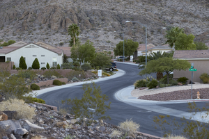
Sun City MacDonald Ranch, Henderson, Nevada: digital photograph
Date
2016-09-14
Archival Collection
Description
Cypress Mesa Drive meanders towards its end in the canyon in the Sun City MacDonald Ranch neighborhood of Henderson, Nevada.
Image
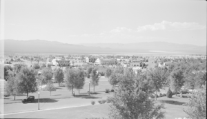
Film transparency showing streets of Boulder City, Nevada, circa 1933-1940s
Date
1933 to 1949
Archival Collection
Description
A view of cars, trees, and buildings in Boulder City; Boulder Dam Hotel and a building sign advertising "free Boulder Dam motion pictures" can be seen in the background.
Image

Photograph of Howard Hughes, Los Angeles, September 11, 1946
Date
1946-09-11
Archival Collection
Description
A view of Howard Hughes in front of a B-23 converted bomber before taking off for New York City in Los Angeles, California.
Image

Map of California, Utah, Nevada, Colorado, New Mexico and Arizona, 1864
Date
1864
Description
'Johnson's California, with Utah, Nevada, Colorado, New Mexico, and Arizona, published by Johnson and Ward.' 'Entered according to Act of Congress in the Year 1864 by A.J. Johnson in the Clerks Office of the District Court of the United States for the southern district of New York.' Atlas page numbers in upper margin: 66-67. This is probably plate 67 from Johnson's New Illustrated Family Atlas, published in New York by Johnson & Ward in 1864. Shows natural features, locations of Indian tribes, proposed railroad routes, routes of explorers, trails, county boundaries and populated places ; "." ; Relief shown by hachures ; Prime meridians: Greenwich and Washington ; In top margin: 66-67 ; Hand colored ; On verso: Historical and statistical view of Mexico and central America (p. 79) and Historical and statistical view of the United States, 1860 (p. 78) Scale [ca. 1:3,484,800]. 1 in. to ca. 55 miles (W 124°--W 102°/N 42°--N 32°)
Text
Sun City MacDonald Ranch as seen from the City View Trail at night, Henderson, Nevada, 2016 September 14
Level of Description
File
Archival Collection
UNLV University Libraries Photographs of the Development of the Las Vegas Valley, Nevada
To request this item in person:
Collection Number: PH-00394
Collection Name: UNLV University Libraries Photographs of the Development of the Las Vegas Valley, Nevada
Box/Folder: N/A
Collection Name: UNLV University Libraries Photographs of the Development of the Las Vegas Valley, Nevada
Box/Folder: N/A
Archival Component