Search Results
Risi, Sue, Hughes Airwest, 1977 March 15
Level of Description
File
Archival Collection
Frank Mitrani Photographs
To request this item in person:
Collection Number: PH-00332
Collection Name: Frank Mitrani Photographs
Box/Folder: Box 06
Collection Name: Frank Mitrani Photographs
Box/Folder: Box 06
Archival Component
Atlantic City Convention Hall: postcards and opening day booklet, 1928
Level of Description
File
Archival Collection
Sonny Schwartz Recordings and Papers
To request this item in person:
Collection Number: MS-00433
Collection Name: Sonny Schwartz Recordings and Papers
Box/Folder: Box 15
Collection Name: Sonny Schwartz Recordings and Papers
Box/Folder: Box 15
Archival Component
#71379: Pictures of and from Hospitality Hall, February 15, 2017, 2017 February 15
Level of Description
Item
Archival Collection
University of Nevada, Las Vegas Creative Services Records (2010s)
To request this item in person:
Collection Number: PH-00388-05
Collection Name: University of Nevada, Las Vegas Creative Services Records (2010s)
Box/Folder: Digital File 01
Collection Name: University of Nevada, Las Vegas Creative Services Records (2010s)
Box/Folder: Digital File 01
Archival Component
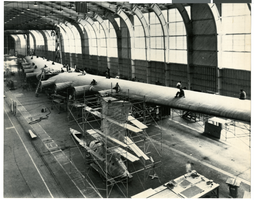
Photograph of the Hughes Flying Boat wing assembly, Culver City, California, circa 1942-46
Date
1942 to 1946
Archival Collection
Description
The Hughes Aircraft HK-1 or "Flying Boat" wing assembly being completed in a hangar in Hughes' factory in Culver City.
Image

Photograph of the landing of Howard Hughes' Lockheed 14 aircraft, New York, July 14, 1938
Date
1938-07-14
Archival Collection
Description
The black and white, aerial view of Howard Hughes' Lockheed 14 aircraft performing its final landing on the Round the World flight in Floyd Bennett Airport, New York. Typed onto a piece of paper attached to the image: "Police get into line before arrival of Howard Hughes at Floyd Bennett Field after Round the World flight. 7/14/38."
Image
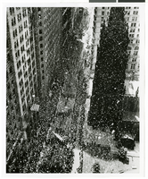
Photograph of a parade procession, New York, July 15, 1938
Date
1938-07-15
Archival Collection
Description
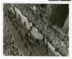
An overhead view of a parade procession celebrating Howard Hughes' completion of his round-the-world flight.
Image
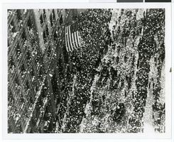
Photograph of a parade procession, New York, July 15, 1938
Date
1938-07-15
Archival Collection
Description
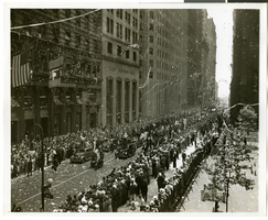
An overhead view of a parade procession celebrating Howard Hughes' completion of his round-the-world flight.
Image
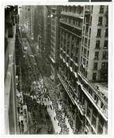
Photograph of a parade procession, New York, July 15, 1938
Date
1938-07-15
Archival Collection
Description
An overhead view of a parade procession celebrating Howard Hughes' completion of his round-the-world flight.
Image
Photograph of a parade procession, New York, July 15, 1938
Date
1938-07-15
Archival Collection
Description
An overhead view of a parade procession celebrating Howard Hughes' completion of his round-the-world flight.
Image
Photograph of a parade procession, New York, July 15, 1938
Date
1938-07-15
Archival Collection
Description
An overhead view of a parade procession celebrating Howard Hughes' completion of his round-the-world flight.
Image